
+38
42
Port Oriel, Clogherhead, Co. Louth, A92V97C
€5,000,000
4180 m²
Commercial Site
Property Overview
- Available From: Immediately
Description
- Overall Floor Area: 4180 m²
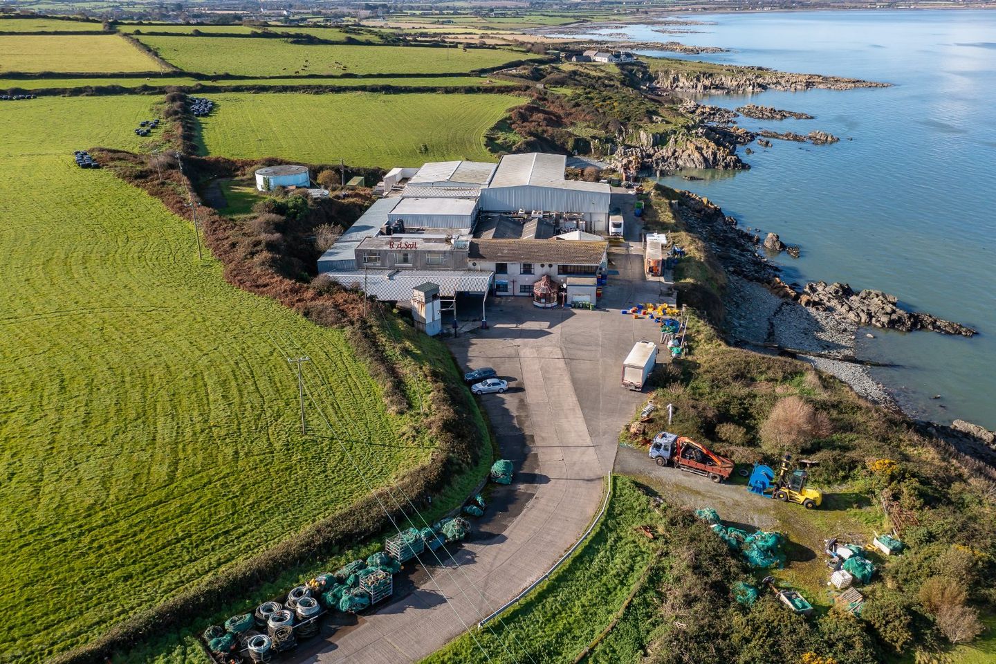
DNG Brady is delighted to bring to the market this substantial Industrial Facility extending to C. 45,000 sq. ft. i.e. 4180 sq.metres, standing on a C. 4.58 acre site overlooking Clogherhead Harbour. The premises is currently used as a fish processing facility together with other associated uses. The property comprises a processing plant, 4 cold store areas, chill store, loading bay, offices, canteen, boardroom and a One-bedroom apartment. This huge facility is ideally suited to its current usage but holding great potential for a variety of purposes. Its size and layout make it suitable for various industrial, commercial, or even redevelopment projects. The proximity to the harbour ensures easy access to maritime activities, making it ideal for businesses related to shipping, logistics, or marine services.
There are 4 tenancies currently in place at the facility (details on request).
The premises extends to 4.58 acres the site is zoned "EM" in the local area plan and falls within control zone 5 as identified in the Louth County Development Plan, thus giving huge potential for a marina based complex/development.
The site is zoned EM "To facilitate opportunities for marine based industry and recreation" so would lend itself to uses in these categories also. Clogherhead Harbour is adjacent to subject property so the site would lend itself to Marine related uses and possible a base for Offshore Renewable Energy Sources.
Clogherhead is a fishing village in Co. Louth. Located in a natural bay on the East Coast it is bordered by the villages of Annagassan to the north and Termonfeckin to the south and is about 12 km northeast of Drogheda. It is a popular location for all types of activities including, fishing, walking, sightseeing and water-based activities when exploring the Boyne Valley. The headland has a walking trail from the village along steep sea cliffs to the nearby harbour of Port Oriel. At low tide, it is also possible to walk the beach as far as the Boyne Estuary. From the headland and at the harbour there are views of Ireland's east coast from the Mourne and Cooley Mountains in the north as far south as Lambay Island.
Port Oriel Harbour is located just outside the village of Clogherhead. It is the largest fishing port in the North East of Ireland.
Development falling within the following categories will be considered within control zone 5:
• Development to be used for leisure
• Recreation and tourism
• Holiday accommodation including cottages and lodges, where these are part of an existing integrated tourism complex
• Hotels/Guesthouses/B&B's
Permitted Uses in Lands Zoned EM
Withing the Clogherhead LAP, the following uses considered permissible on the subject lands:
Harbour Development
Marine Based Industry
Marine Based Recreational Facilities
Offshore Renewable Energy Base
The Three Wells is strategically located for offshore wind farm developers and/or CTV (crew transfer vessel) operators in the form of an OMF (Operations and Maintenance Facility).
With natural water depth sufficient to facilitate 24hr CTV access that the industry strives for, a simple floating jetty construction away from the busy fishery harbour area would facilitate the walk to work mantra of those involved in the industry. Natural protection from south and west winds by way of the headland, and easterly winds owing to the pier at Port Oriel, safe entry for all vessels is maximized.
An existing brown field site with current warehouse and office space, road and water access adjacent make it very attractive to the industry. A bird's eye view of future operations and the arrival and departure of wind farm related vessels.
Crewing the vessels can be facilitated locally with those involved in the fishing industry retraining and upskilling a natural workforce from the hinterland. Experienced and qualified mariners.
Only 15minutes from the M1 motorway, the Northern Cross Port Access Route under construction and rail access via Drogheda and Dundalk train stations, staff would find the commute and possible relocation to the seaside village a pleasure.
All services are installed/nearby, which includes water, sewerage and electricity.
Map
Map
Local AreaNEW

Learn more about what this area has to offer.
School Name | Distance | Pupils | |||
|---|---|---|---|---|---|
| School Name | Callystown National School | Distance | 210m | Pupils | 281 |
| School Name | Walshestown National School | Distance | 3.9km | Pupils | 102 |
| School Name | Scoil Náisíunta Naomh Feichín | Distance | 4.1km | Pupils | 283 |
School Name | Distance | Pupils | |||
|---|---|---|---|---|---|
| School Name | Sandpit National School | Distance | 4.8km | Pupils | 236 |
| School Name | St. Patrick's National School | Distance | 7.3km | Pupils | 193 |
| School Name | Scoil Naomh Cholmcille | Distance | 7.7km | Pupils | 171 |
| School Name | Aston Village Educate Together National School | Distance | 8.7km | Pupils | 385 |
| School Name | Le Cheile Educate Together National School | Distance | 9.1km | Pupils | 403 |
| School Name | Presentation Primary School | Distance | 9.4km | Pupils | 268 |
| School Name | Réalt Na Mara Girls School | Distance | 9.6km | Pupils | 432 |
School Name | Distance | Pupils | |||
|---|---|---|---|---|---|
| School Name | Drogheda Grammar School | Distance | 9.0km | Pupils | 510 |
| School Name | Ballymakenny College | Distance | 9.4km | Pupils | 993 |
| School Name | St. Joseph's C.b.s. | Distance | 9.4km | Pupils | 863 |
School Name | Distance | Pupils | |||
|---|---|---|---|---|---|
| School Name | Our Lady's College | Distance | 9.6km | Pupils | 926 |
| School Name | Scoil Ui Mhuiri | Distance | 9.7km | Pupils | 631 |
| School Name | Colaiste Na Hinse | Distance | 10.5km | Pupils | 1087 |
| School Name | Sacred Heart Secondary School | Distance | 11.0km | Pupils | 690 |
| School Name | Laytown & Drogheda Educate Together Secondary School | Distance | 11.2km | Pupils | 279 |
| School Name | St Mary's Diocesan School | Distance | 11.4km | Pupils | 902 |
| School Name | St. Oliver's Community College | Distance | 12.3km | Pupils | 1514 |
Type | Distance | Stop | Route | Destination | Provider | ||||||
|---|---|---|---|---|---|---|---|---|---|---|---|
| Type | Bus | Distance | 500m | Stop | Clogher | Route | 168 | Destination | Dundalk | Provider | Bus Éireann |
| Type | Bus | Distance | 510m | Stop | Clogher Village | Route | 168 | Destination | Drogheda | Provider | Bus Éireann |
| Type | Bus | Distance | 830m | Stop | Hackets Cross | Route | 168 | Destination | Drogheda | Provider | Bus Éireann |
Type | Distance | Stop | Route | Destination | Provider | ||||||
|---|---|---|---|---|---|---|---|---|---|---|---|
| Type | Bus | Distance | 830m | Stop | Hackets Cross | Route | 168 | Destination | Dundalk | Provider | Bus Éireann |
| Type | Bus | Distance | 3.6km | Stop | Termonfeckin | Route | 168 | Destination | Dundalk | Provider | Bus Éireann |
| Type | Bus | Distance | 3.6km | Stop | Termonfeckin | Route | 168 | Destination | Drogheda | Provider | Bus Éireann |
| Type | Bus | Distance | 6.4km | Stop | Baltray | Route | 168 | Destination | Drogheda | Provider | Bus Éireann |
| Type | Bus | Distance | 6.4km | Stop | Grangebellew | Route | 168 | Destination | Drogheda | Provider | Bus Éireann |
| Type | Bus | Distance | 6.4km | Stop | Grangebellew | Route | 168 | Destination | Dundalk | Provider | Bus Éireann |
| Type | Bus | Distance | 6.4km | Stop | Baltray | Route | 168 | Destination | Dundalk | Provider | Bus Éireann |
Statistics
27/04/2024
Entered/Renewed
1,341
Property Views
Daft ID: 518895301


Donal A. Brady, MSCSI MRICS ACIArb, Managing Director
041 9809999