
+5
9
Bell Height, Kenmare, Co. Kerry, V93X953
Price on Application
5.88 ac
Development Land
Property Overview
- Available From: Immediately
Description
- Sale Type: For Sale by Private Treaty
- Overall Floor Area: 5.88 ac
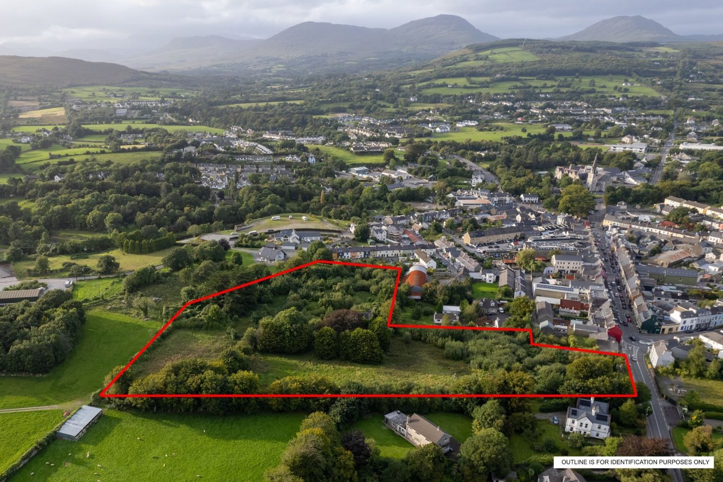
Bell Height & The Shrubberies, Kenmare, Co. Kerry
For Sale by Private Treaty
Prime one-off opportunity to develop a standout commercial/ residential development site situated in a most central location in the heart of the award-winning town of Kenmare. The property is situated in a high-profile position to the town centre, directly fronting onto the Bell Height adjacent to Henry Street and Shelbourne Street, adjacent to the Park Hotel.
The land holding extends to approx. 2.38 ha (5.88 acres) with extensive road frontage of approx. 48 metres onto the Bell Height Road is zoned as mixed use in the Kenmare Local Area Plan 2022-2028.
The property consists of a L shaped site of approx. 2.38 ha (5.88 acres) in total, comprised in two folios, KY72189F & KY79879F. The property is fairly level and is currently under scrub vegetation and overgrown. There are a series of trees/shrubs on the western section of the site and along its southern and northern boundary around the existing derelict building. Access to the property is mainly along the Bell Height and has secondary access via New Road.
Prominent site extending to approximately 2.38 ha (5.88 acres).
Commercial/ Residential development opportunity subject to planning permission
Zoned "town centre" under the new proposed zoning.
High profile site with extensive road frontage on to Bell Height
Road frontage onto Bell Height, secondary access on New Road
Centrally located in Kenmare town directly opposite the Five Star Park Hotel & Spa.
The site includes "The Shurbberies", a derelict two-storey listed building.
Contained in folios KY72189F & KY79879F
The Shrubberies
The original site was on a former Monastery but became home to Irvine and Brennan families in the early 1800's who intended to use the property as a nursery to replant the woodland in the surround area. The property which still goes by the name of the 'Shrubberies', consists of 2-3 storey semi derelict building with surrounding natural stone walls.
Map
Map
Local AreaNEW

Learn more about what this area has to offer.
School Name | Distance | Pupils | |||
|---|---|---|---|---|---|
| School Name | St Johns National School | Distance | 800m | Pupils | 401 |
| School Name | Cahir National School | Distance | 4.3km | Pupils | 39 |
| School Name | Tulloha National School | Distance | 6.9km | Pupils | 26 |
School Name | Distance | Pupils | |||
|---|---|---|---|---|---|
| School Name | Kilgarvan National School | Distance | 10.3km | Pupils | 108 |
| School Name | The Black Valley National School | Distance | 12.8km | Pupils | 2 |
| School Name | Tuosist School | Distance | 13.9km | Pupils | 85 |
| School Name | Scoil Fhiachna Glengarriff | Distance | 14.2km | Pupils | 61 |
| School Name | Derrycreha National School | Distance | 16.4km | Pupils | 28 |
| School Name | Tahilla Community National School | Distance | 17.1km | Pupils | 32 |
| School Name | Coomhola National School | Distance | 17.6km | Pupils | 94 |
School Name | Distance | Pupils | |||
|---|---|---|---|---|---|
| School Name | Pobalscoil Inbhear Scéine | Distance | 590m | Pupils | 570 |
| School Name | St. Brigid's Presentation Secondary School | Distance | 20.7km | Pupils | 746 |
| School Name | St Brendan's College | Distance | 20.9km | Pupils | 863 |
School Name | Distance | Pupils | |||
|---|---|---|---|---|---|
| School Name | Killarney Community College | Distance | 21.0km | Pupils | 446 |
| School Name | Scoil Mhuire | Distance | 24.2km | Pupils | 86 |
| School Name | Colaiste Pobail Bheanntraí | Distance | 24.5km | Pupils | 710 |
| School Name | Killorglin Community College | Distance | 28.3km | Pupils | 287 |
| School Name | The Intermediate School | Distance | 29.3km | Pupils | 596 |
| School Name | Colaiste Ghobnatan | Distance | 30.2km | Pupils | 254 |
| School Name | Presentation Secondary School | Distance | 31.0km | Pupils | 688 |
Type | Distance | Stop | Route | Destination | Provider | ||||||
|---|---|---|---|---|---|---|---|---|---|---|---|
| Type | Bus | Distance | 260m | Stop | Kenmare | Route | 281 | Destination | Kenmare | Provider | Tfi Local Link Kerry |
| Type | Bus | Distance | 260m | Stop | Kenmare | Route | 270 | Destination | Skibbereen | Provider | Bus Éireann |
| Type | Bus | Distance | 260m | Stop | Kenmare | Route | 281 | Destination | Waterville | Provider | Tfi Local Link Kerry |
Type | Distance | Stop | Route | Destination | Provider | ||||||
|---|---|---|---|---|---|---|---|---|---|---|---|
| Type | Bus | Distance | 260m | Stop | Kenmare | Route | 270 | Destination | Kenmare | Provider | Bus Éireann |
| Type | Bus | Distance | 260m | Stop | Kenmare | Route | 270 | Destination | Killarney | Provider | Bus Éireann |
| Type | Bus | Distance | 7.1km | Stop | Templenoe Church | Route | 281 | Destination | Waterville | Provider | Tfi Local Link Kerry |
| Type | Bus | Distance | 7.1km | Stop | Templenoe Church | Route | 281 | Destination | Kenmare | Provider | Tfi Local Link Kerry |
| Type | Bus | Distance | 10.4km | Stop | Kilgarvan | Route | 270 | Destination | Skibbereen | Provider | Bus Éireann |
| Type | Bus | Distance | 10.4km | Stop | Kilgarvan | Route | 270 | Destination | Kenmare | Provider | Bus Éireann |
| Type | Bus | Distance | 10.4km | Stop | Kilgarvan | Route | 270 | Destination | Killarney | Provider | Bus Éireann |
BER Details

Statistics
18/04/2024
Entered/Renewed
0
Property Views
Daft ID: 517770814
Contact Agent

Tadhg O'Sullivan
064 6641566