
Part Ground Floor, The Grange, Stillorgan Road, Stillorgan, Leopardstown, Dublin 18
Rent Negotiable
- Unit Price:€0.00 per sq. m per month
- Available From:Immediately
About Part Ground Floor, The Grange, Stillorgan Road, Stillorgan
Description
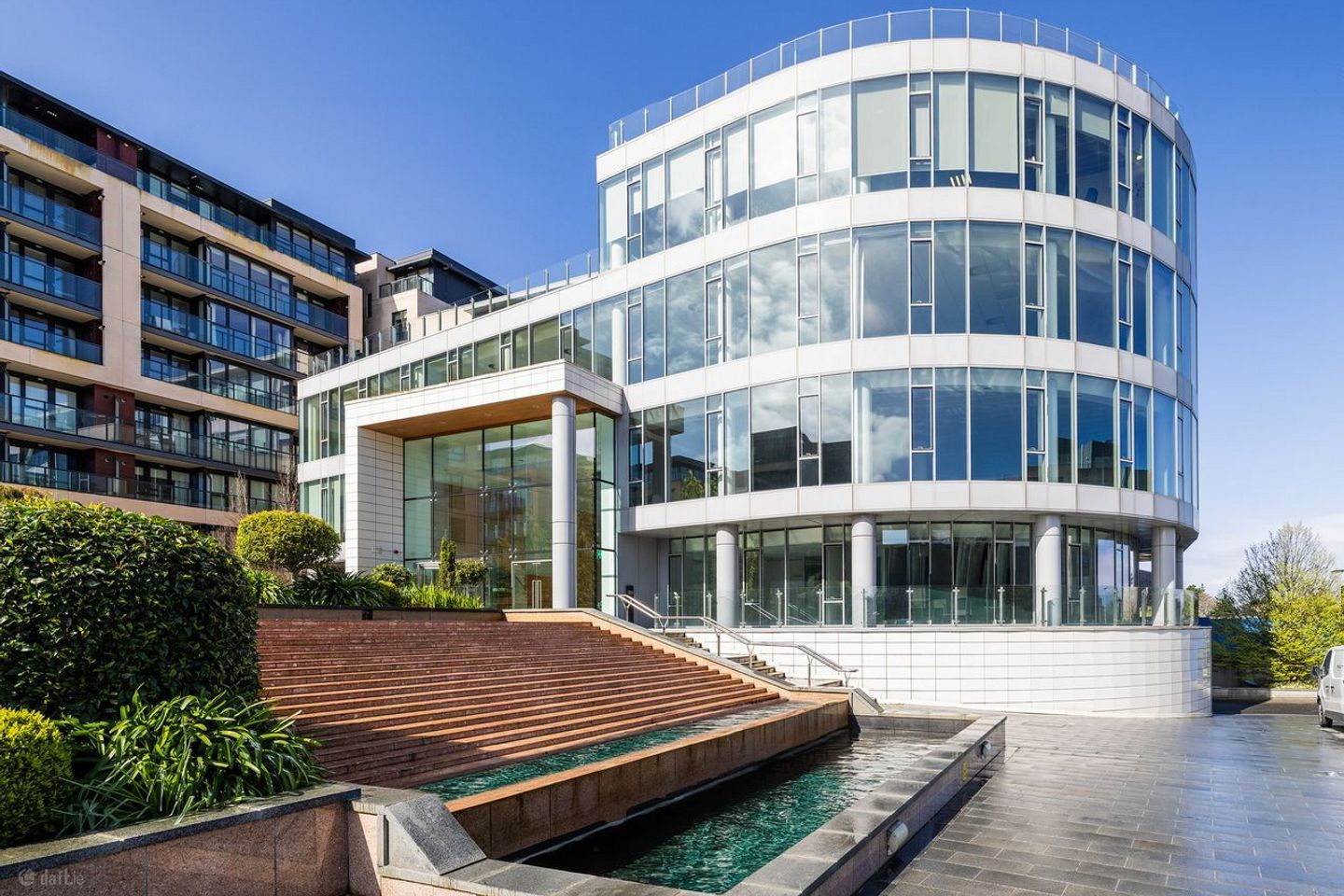
Description: The Grange is a modern five-storey office building which provides high-quality & efficient workspace for occupiers. The available accommodation extends to approximately 25,139 sq. ft. across the Ground, 1st & 2nd Floors, with single suites ranging from 1,896sq. ft. to 11,168 sq. ft. The impressive double-height reception area provides a modern and welcoming first impression to tenants & visitors alike. The floor plates are flexible, efficient and can be adapted to suite a variety of business needs. All floors benefit from floor to ceiling windows, which allows for excellent natural light throughout. The property enjoys ample car parking at basement level as well as secure bicycle parking & shower facilities. Specification: - Raised Access Floors - Floor boxes wired for power & data. - Carpet tiles throughout - Open Plan & Cellular offices - Suspended ceilings - LED lighting - Air conditioning - Kitchenette - Comms Room - Ladies, Gents & Disabled toilet facilities - X2 Passenger lifts - BER: C3 Location: Situated approximately 8km south of Dublin City Centre, The Grange benefits from excellent transport connectivity, making it an ideal location for organisations seeking convenient access to city while also enjoying the advantages of a suburban setting. Strategically positioned adjacent to the N11 dual carriageway, the scheme benefits from immediate access to Dublin City Centre, the M50 motorway and the wider national road network. The area is well served by multiple Dublin bus routes, while the Luas green line is easily accessible at the Sandyford park & ride stop. Dedicated cycle lanes also offer commuters a safe and direct route to the city centre. Amenities in the surrounding area include the Stillorgan Village Centre, Beacon South Quarter, Giraffe Childcare & The Leopardstown Inn.
Standard features
The local area of Part Ground Floor, The Grange, Stillorgan Road, Stillorgan
Local schools and transport

Learn more about what this area has to offer.
School Name | Distance | Pupils | |||
|---|---|---|---|---|---|
| School Name | Setanta Special School | Distance | 330m | Pupils | 65 |
| School Name | St Brigids National School | Distance | 520m | Pupils | 102 |
| School Name | St Raphaela's National School | Distance | 800m | Pupils | 408 |
School Name | Distance | Pupils | |||
|---|---|---|---|---|---|
| School Name | St. Augustine's School | Distance | 1.1km | Pupils | 159 |
| School Name | Hollypark Girls National School | Distance | 1.2km | Pupils | 487 |
| School Name | Hollypark Boys National School | Distance | 1.2km | Pupils | 512 |
| School Name | All Saints National School Blackrock | Distance | 1.2km | Pupils | 50 |
| School Name | St Laurence's Boys National School | Distance | 1.3km | Pupils | 402 |
| School Name | Goatstown Stillorgan Primary School | Distance | 1.3km | Pupils | 141 |
| School Name | Oatlands Primary School | Distance | 1.4km | Pupils | 420 |
School Name | Distance | Pupils | |||
|---|---|---|---|---|---|
| School Name | St Raphaela's Secondary School | Distance | 850m | Pupils | 631 |
| School Name | Oatlands College | Distance | 1.4km | Pupils | 634 |
| School Name | Loreto College Foxrock | Distance | 1.4km | Pupils | 637 |
School Name | Distance | Pupils | |||
|---|---|---|---|---|---|
| School Name | Newpark Comprehensive School | Distance | 1.6km | Pupils | 849 |
| School Name | Nord Anglia International School Dublin | Distance | 1.6km | Pupils | 630 |
| School Name | St Benildus College | Distance | 1.9km | Pupils | 925 |
| School Name | Rockford Manor Secondary School | Distance | 2.1km | Pupils | 285 |
| School Name | Dominican College Sion Hill | Distance | 2.3km | Pupils | 508 |
| School Name | Mount Anville Secondary School | Distance | 2.4km | Pupils | 712 |
| School Name | Coláiste Íosagáin | Distance | 2.5km | Pupils | 488 |
Type | Distance | Stop | Route | Destination | Provider | ||||||
|---|---|---|---|---|---|---|---|---|---|---|---|
| Type | Bus | Distance | 110m | Stop | Brewery Road | Route | 46n | Destination | Dundrum | Provider | Nitelink, Dublin Bus |
| Type | Bus | Distance | 110m | Stop | Brewery Road | Route | E2 | Destination | Dun Laoghaire | Provider | Dublin Bus |
| Type | Bus | Distance | 110m | Stop | Brewery Road | Route | X1 | Destination | Kilcoole | Provider | Dublin Bus |
Type | Distance | Stop | Route | Destination | Provider | ||||||
|---|---|---|---|---|---|---|---|---|---|---|---|
| Type | Bus | Distance | 160m | Stop | Farmleigh Avenue | Route | 118 | Destination | Eden Quay | Provider | Dublin Bus |
| Type | Bus | Distance | 180m | Stop | Brewery Road | Route | E1 | Destination | Parnell Square | Provider | Dublin Bus |
| Type | Bus | Distance | 180m | Stop | Brewery Road | Route | X2 | Destination | Hawkins Street | Provider | Dublin Bus |
| Type | Bus | Distance | 200m | Stop | Galloping Green | Route | 46n | Destination | Dundrum | Provider | Nitelink, Dublin Bus |
| Type | Bus | Distance | 200m | Stop | Galloping Green | Route | E2 | Destination | Dun Laoghaire | Provider | Dublin Bus |
| Type | Bus | Distance | 220m | Stop | Galloping Green | Route | E1 | Destination | Parnell Square | Provider | Dublin Bus |
| Type | Bus | Distance | 420m | Stop | Ellesmere | Route | 118 | Destination | Eden Quay | Provider | Dublin Bus |
BER Details
Ad performance
- Date listed13/04/2026
- Views158
Daft ID: 56543260