
15,17 Synge Street, Dublin 8, Portobello, Dublin 8, D08XV74
€3,750,000
- Available From:Immediately
About 15,17 Synge Street, Dublin 8, Portobello, Dublin 8
Description
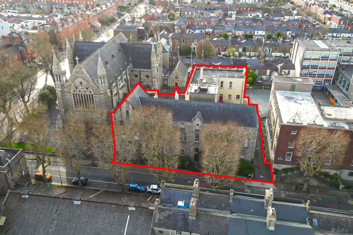
The property extends to a total gross internal area of approximately 2,187.7 sq m (23,548 sq ft), excluding a large cellar. It comprises a main structure of 1,749.1 sq m (18,827 sq ft) and a rear self-contained education centre of 438.5 sq m (4,721 sq ft). The entire occupies a site of 0.16 hectares (0.4 acres). Several on-site car parking spaces are provided in a courtyard which has a barrier access. The property was originally constructed in 1863 as a Gothic Revival styled building designed by acclaimed historical architect John Bourke. Mr. Bourke designed many religious buildings throughout Ireland during the mid to late 19th century including the Mater Misericordiae Hospital (The Mater), St Mary’s Dominican Convent and Belgrave Square. The building comprises the original period structure fronting Synge Street (1860s), with two main extensions added in the 1900s. The front property was originally a monastery and a school. Since 2022, until early 2026, it was used for short-term residential accommodation. The Synge Street section sits over a lower ground floor to one side, and cellar to the other. It has several reception/community rooms throughout the ground and first floors as well as a catering kitchen and large dining area. The second floor has 21 bedrooms, each with a whb. Shared toilet/shower accommodation is provided. There is another bedroom (studio) in the lower ground floor. The buiding retains many of its original architectural features including stained-glass windows, high ceilings with cornicing, and granite framed window openings featuring pointed arches. External features include a stone carved facade fronting Synge Street. *Education Centre* The three-storey section at the rear of the property (c.4,721 sq ft) has been used as an adult education facility for the past decade. It is fully-self contained and presents very well having been reconfigured and upgraded during that time. It is laid out to provide several classrooms on each of the two upper floors. *Location* The former Monastery on Synge Street is located in Dublin’s south city core, just off South Circular Road and close to Camden Street. LUAS Green Line Stop at Harcourt Street is within a several minute walk from the property. Several bus routes serve the locality. City centre tourist attractions nearby include the National Concert Hall, Iveagh Gardens and an abundance of bars and restaurants, all within a short walk. There are several hotels within the immediate area. A new hotel is proposed nearby on Pleasant Street. Synge Street is a short walk to the Dublin 2 business district, the vibrant entertainment hub around Camden Street, St. Stephen’s Green and the prime retail district around Grafton Street. The property is located between Bunscoil (ERST) Sancta Maria Primary School to its north and St. Kevin’s Church to its south. Synge Street Secondary School is located to the rear. *Zoning* The property is located within an area zoned Z15 (Institutional and Community) within the Dublin City Development Plan 2022-2028. “To protect and provide for Institutional and Community uses” ‘Permissible Uses’ identified under Z15 within the Plan include: “Assisted living/retirement home, buildings for the health, safety and welfare of the public, café/tearoom (associated with the primary use), cemetery, childcare facility, club house and associated sports facilities, community facility, cultural/recreational building and uses, education, medical and related consultants, open space, place of public worship, primary health care centre, public service installation, residential institution (and ancillary residential accommodation for staff), sports facility and recreational uses”. Uses ‘Open for Consideration’ under Z15 include: “Allotments, car park ancillary to main use, civic and amenity/recycling centre, conference centre (associated with the primary use), crematorium, craft centre/ craft shop (associated with the primary use), municipal golf course, residential (only in accordance with the highly exceptional circumstances set out above), restaurant, shop (local), student accommodation (associated with the primary institutional use), training centre (associated with the primary use), veterinary surgery”. *Record of Protected Structure* Part of the property is identified under the Record of Protected Structures within the Dublin City Development Plan 2022-2028. The listing for 17 Synge Street (Ref. 7927), is described as: “Former Christian Brothers school and monastery, excluding rear extensions”
The local area of 15,17 Synge Street, Dublin 8, Portobello, Dublin 8
Local schools and transport

Learn more about what this area has to offer.
School Name | Distance | Pupils | |||
|---|---|---|---|---|---|
| School Name | Bunscoil Synge Street | Distance | 40m | Pupils | 101 |
| School Name | Presentation Primary School | Distance | 670m | Pupils | 229 |
| School Name | St Patrick's Cathedral Choir School | Distance | 750m | Pupils | 23 |
School Name | Distance | Pupils | |||
|---|---|---|---|---|---|
| School Name | South City Cns | Distance | 820m | Pupils | 161 |
| School Name | St Brigid's Primary School | Distance | 820m | Pupils | 228 |
| School Name | Scoil Treasa Naofa | Distance | 820m | Pupils | 165 |
| School Name | Harcourt Terrace Educate Together National School | Distance | 870m | Pupils | 206 |
| School Name | Griffith Barracks Multi D School | Distance | 870m | Pupils | 387 |
| School Name | St Clare's Primary School | Distance | 910m | Pupils | 181 |
| School Name | St. Louis National School | Distance | 930m | Pupils | 622 |
School Name | Distance | Pupils | |||
|---|---|---|---|---|---|
| School Name | Synge Street Cbs Secondary School | Distance | 90m | Pupils | 291 |
| School Name | St. Mary's College C.s.sp., Rathmines | Distance | 620m | Pupils | 498 |
| School Name | St Patricks Cathedral Grammar School | Distance | 730m | Pupils | 302 |
School Name | Distance | Pupils | |||
|---|---|---|---|---|---|
| School Name | Presentation College | Distance | 780m | Pupils | 221 |
| School Name | Catholic University School | Distance | 790m | Pupils | 547 |
| School Name | Loreto College | Distance | 840m | Pupils | 584 |
| School Name | Rathmines College | Distance | 1.0km | Pupils | 55 |
| School Name | Harolds Cross Educate Together Secondary School | Distance | 1.2km | Pupils | 350 |
| School Name | St. Louis High School | Distance | 1.3km | Pupils | 684 |
| School Name | C.b.s. Westland Row | Distance | 1.6km | Pupils | 202 |
Type | Distance | Stop | Route | Destination | Provider | ||||||
|---|---|---|---|---|---|---|---|---|---|---|---|
| Type | Bus | Distance | 50m | Stop | Harrington Street | Route | 68a | Destination | Poolbeg St | Provider | Dublin Bus |
| Type | Bus | Distance | 50m | Stop | Harrington Street | Route | 16 | Destination | Dublin Airport | Provider | Dublin Bus |
| Type | Bus | Distance | 50m | Stop | Harrington Street | Route | 122 | Destination | Ashington | Provider | Dublin Bus |
Type | Distance | Stop | Route | Destination | Provider | ||||||
|---|---|---|---|---|---|---|---|---|---|---|---|
| Type | Bus | Distance | 90m | Stop | Harrington Street | Route | 16d | Destination | Ballinteer | Provider | Dublin Bus |
| Type | Bus | Distance | 110m | Stop | Harrington Street | Route | 125 | Destination | Toughers Ind Est | Provider | Go-ahead Ireland |
| Type | Bus | Distance | 110m | Stop | Harrington Street | Route | 68 | Destination | Greenogue | Provider | Dublin Bus |
| Type | Bus | Distance | 160m | Stop | Camden Street Lower | Route | 142 | Destination | Coast Road | Provider | Dublin Bus |
| Type | Bus | Distance | 160m | Stop | Camden Street Lower | Route | 15d | Destination | Merrion Square | Provider | Dublin Bus |
| Type | Bus | Distance | 160m | Stop | Camden Street Lower | Route | 14 | Destination | Eden Quay | Provider | Dublin Bus |
| Type | Bus | Distance | 180m | Stop | Victoria Street | Route | 16d | Destination | Ballinteer | Provider | Dublin Bus |
Ad performance
- Date listed22/05/2026
- Views2,227
Daft ID: 56578139