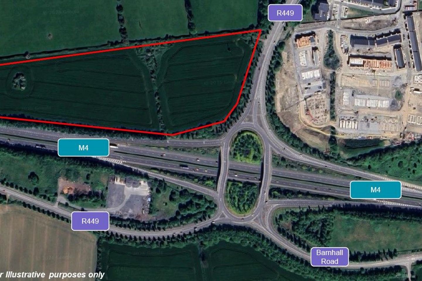

20.36 Acres Of Land , Celbridge, Co. Kildare
Price on Application
20.36 acDevelopment Land
- Available From:Immediately
About this property
Description
LOCATION - located on the north side of the M4 Motorway, and west of the R449. - To the Northeast is Leixlip and to the South is Celbridge. - The M4 offers connectivity to Maynooth to the West (5km) and Lucan to the East (6km). - National routes such as the M3 (8km) and the N7 (15km) are close by. - Leixlip Louisa Bridge train station is situated 2km away. DESCRIPTION - The land is held under the Folio KE3071F (Freehold) and is zoned 'Agriculture'. - It is a greenfield site and is an irregular shape and has the benefit of a flat topography. - Access to the land can be found of a dirt road to the west of the R449.
The local area
The local area
Local schools and transport

Learn more about what this area has to offer.
School Name | Distance | Pupils | |||
|---|---|---|---|---|---|
| School Name | Aghards National School | Distance | 1.6km | Pupils | 665 |
| School Name | Leixlip Etns | Distance | 1.8km | Pupils | 179 |
| School Name | Scoil Eoin Phóil | Distance | 2.3km | Pupils | 272 |
School Name | Distance | Pupils | |||
|---|---|---|---|---|---|
| School Name | Leixlip Boys National School | Distance | 2.3km | Pupils | 306 |
| School Name | Scoil Mhuire Leixlip | Distance | 2.4km | Pupils | 298 |
| School Name | Scoil Naomh Bríd | Distance | 2.4km | Pupils | 258 |
| School Name | Scoil Na Mainistreach | Distance | 2.6km | Pupils | 460 |
| School Name | St Raphaels School Celbridge | Distance | 2.7km | Pupils | 97 |
| School Name | Primrose Hill National School | Distance | 2.7km | Pupils | 113 |
| School Name | Scoil Chearbhaill Uí Dhálaigh | Distance | 2.7km | Pupils | 381 |
School Name | Distance | Pupils | |||
|---|---|---|---|---|---|
| School Name | Celbridge Community School | Distance | 970m | Pupils | 714 |
| School Name | Salesian College | Distance | 1.1km | Pupils | 842 |
| School Name | Coláiste Chiaráin | Distance | 2.4km | Pupils | 638 |
School Name | Distance | Pupils | |||
|---|---|---|---|---|---|
| School Name | Confey Community College | Distance | 2.8km | Pupils | 911 |
| School Name | St Wolstans Community School | Distance | 3.5km | Pupils | 820 |
| School Name | Maynooth Community College | Distance | 4.8km | Pupils | 962 |
| School Name | Maynooth Post Primary School | Distance | 4.8km | Pupils | 1018 |
| School Name | Gaelcholáiste Mhaigh Nuad | Distance | 4.9km | Pupils | 129 |
| School Name | Adamstown Community College | Distance | 5.6km | Pupils | 980 |
| School Name | Lucan Community College | Distance | 5.9km | Pupils | 966 |
Type | Distance | Stop | Route | Destination | Provider | ||||||
|---|---|---|---|---|---|---|---|---|---|---|---|
| Type | Bus | Distance | 790m | Stop | M4 Business Park | Route | L59 | Destination | Hazelhatch Station | Provider | Dublin Bus |
| Type | Bus | Distance | 960m | Stop | Beechpark Estate | Route | L59 | Destination | River Forest | Provider | Dublin Bus |
| Type | Bus | Distance | 960m | Stop | Beechpark Estate | Route | 52 | Destination | Ringsend Road | Provider | Dublin Bus |
Type | Distance | Stop | Route | Destination | Provider | ||||||
|---|---|---|---|---|---|---|---|---|---|---|---|
| Type | Bus | Distance | 960m | Stop | Beechpark Estate | Route | X25 | Destination | Ucd Belfield | Provider | Dublin Bus |
| Type | Bus | Distance | 980m | Stop | Beechpark Estate | Route | C5 | Destination | Maynooth | Provider | Dublin Bus |
| Type | Bus | Distance | 1.0km | Stop | Crodaun Forest Park | Route | X28 | Destination | Ucd Belfield | Provider | Dublin Bus |
| Type | Bus | Distance | 1.0km | Stop | Crodaun Forest Park | Route | L59 | Destination | Hazelhatch Station | Provider | Dublin Bus |
| Type | Bus | Distance | 1.0km | Stop | Crodaun Forest Park | Route | C6 | Destination | Ringsend Road | Provider | Dublin Bus |
| Type | Bus | Distance | 1.1km | Stop | Salesian College | Route | X28 | Destination | Ucd Belfield | Provider | Dublin Bus |
| Type | Bus | Distance | 1.1km | Stop | Salesian College | Route | W6 | Destination | The Square | Provider | Go-ahead Ireland |
Ad performance
- Date listed11/03/2026
- Views792
Daft ID: 56517212