
Approx. 27.7 acres at, Kilquade Hill, Kilquade, Co. Wicklow
Price on Application
- Available From:Immediately
About Approx. 27.7 acres at, Kilquade Hill, Kilquade
Description
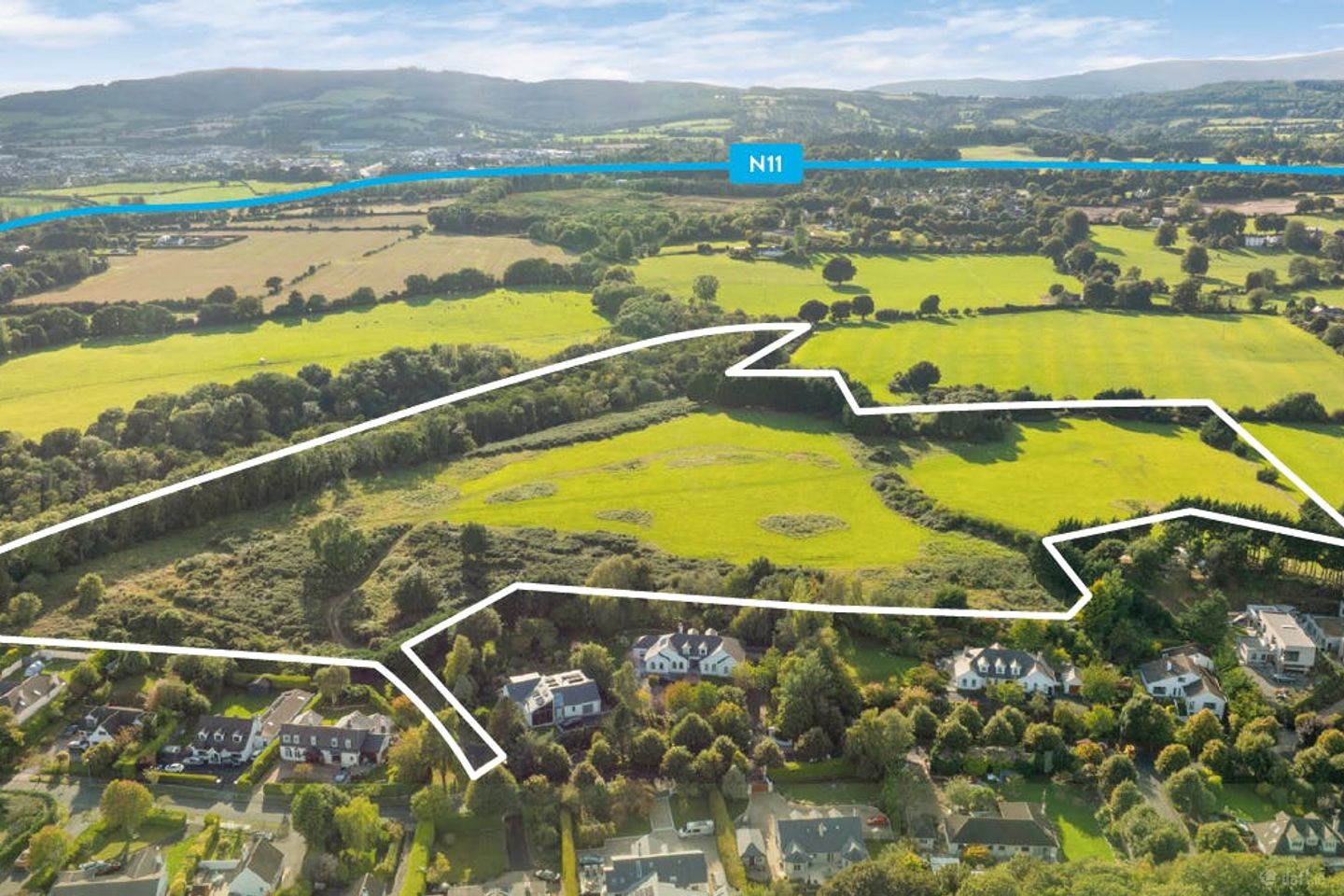
The property comprises a large irregular shaped greenfield site of approx. 11.2 ha (27.7 acres). The site benefits from two separate access points, both off the established Kilquade Hill settlement. To the east, the lands adjoin mature housing within Kilquade Hill, while the wider setting includes a mix of residential and community uses. The surrounding area is predominantly residential in character, comprising a mix of detached family homes set within mature, landscaped plots. The location is well established and enjoys convenient access to local amenities, including schools, neighbourhood shops, and a range of recreational and leisure facilities in nearby Greystones and Delgany. The property is situated adjoining the Kilquade Hill development, in the heart of Kilquade, Co. Wicklow, approximately 5.3 km from Greystones, 4.5 km from Delgany, and just 12km south of Bray. The surrounding area is a highly desirable residential location, noted for its high value homes, coastal setting, and proximity to both the Wicklow countryside and the amenities of North Wicklow’s larger towns. Residents benefit from a wide array of local amenities, including schools, shops, cafs, and community facilities such as the Druids Glen Hotel and Golf Resort located directly to the south of the subject lands and National Garden Exhibition Centre. The property is well connected by transport links, with convenient access to the N11 corridor, providing a direct route to Dublin and the southeast. Greystones DART station, located just a short drive away, offers regular rail services to Dublin City Centre. Key Points: - The property is located adjacent the existing Kilquade Hill development in Kilquade, Co. Wicklow approximately 2.4km from Kilcoole, 4.5km from Delgany and 5.3km from Greystones. - Prime landbank with future development potential extending to approximately 11.2 ha (27.7 acres). - Fully serviced site with direct connections to mains water and wastewater networks - Located adjacent existing residential
The local area of Approx. 27.7 acres at, Kilquade Hill, Kilquade
Local schools and transport

Learn more about what this area has to offer.
School Name | Distance | Pupils | |||
|---|---|---|---|---|---|
| School Name | St Francis National School | Distance | 1.2km | Pupils | 95 |
| School Name | Woodstock Educate Together National School | Distance | 2.1km | Pupils | 117 |
| School Name | Newtownmountkennedy Primary School | Distance | 2.2km | Pupils | 365 |
School Name | Distance | Pupils | |||
|---|---|---|---|---|---|
| School Name | St Catherine's Special School | Distance | 2.3km | Pupils | 89 |
| School Name | Kilcoole Primary School | Distance | 3.4km | Pupils | 575 |
| School Name | Delgany National School | Distance | 5.6km | Pupils | 207 |
| School Name | Greystones Community National School | Distance | 5.9km | Pupils | 411 |
| School Name | St Laurence's National School | Distance | 6.5km | Pupils | 673 |
| School Name | St Brigid's National School | Distance | 7.4km | Pupils | 389 |
| School Name | St Kevin's National School | Distance | 7.4km | Pupils | 458 |
School Name | Distance | Pupils | |||
|---|---|---|---|---|---|
| School Name | Colaiste Chraobh Abhann | Distance | 2.5km | Pupils | 774 |
| School Name | Greystones Community College | Distance | 5.7km | Pupils | 630 |
| School Name | St David's Holy Faith Secondary | Distance | 7.3km | Pupils | 772 |
School Name | Distance | Pupils | |||
|---|---|---|---|---|---|
| School Name | Temple Carrig Secondary School | Distance | 7.9km | Pupils | 946 |
| School Name | East Glendalough School | Distance | 10.8km | Pupils | 366 |
| School Name | Coláiste Chill Mhantáin | Distance | 10.8km | Pupils | 933 |
| School Name | St. Kilian's Community School | Distance | 11.8km | Pupils | 416 |
| School Name | Wicklow Educate Together Secondary School | Distance | 12.0km | Pupils | 375 |
| School Name | Dominican College | Distance | 12.1km | Pupils | 473 |
| School Name | Pres Bray | Distance | 12.2km | Pupils | 649 |
Type | Distance | Stop | Route | Destination | Provider | ||||||
|---|---|---|---|---|---|---|---|---|---|---|---|
| Type | Bus | Distance | 1.0km | Stop | Newcastle Hospital | Route | 131 | Destination | Wicklow | Provider | Bus Éireann |
| Type | Bus | Distance | 1.1km | Stop | Newcastle Hospital | Route | L1 | Destination | Bray Station | Provider | Go-ahead Ireland |
| Type | Bus | Distance | 1.1km | Stop | Newcastle Hospital | Route | 133 | Destination | Dublin | Provider | Bus Éireann |
Type | Distance | Stop | Route | Destination | Provider | ||||||
|---|---|---|---|---|---|---|---|---|---|---|---|
| Type | Bus | Distance | 1.1km | Stop | Drake's Way | Route | L1 | Destination | Newtownmountkennedy | Provider | Go-ahead Ireland |
| Type | Bus | Distance | 1.2km | Stop | Leabeg Lane | Route | L2 | Destination | Newcastle | Provider | Go-ahead Ireland |
| Type | Bus | Distance | 1.3km | Stop | Trudder Farm | Route | L1 | Destination | Bray Station | Provider | Go-ahead Ireland |
| Type | Bus | Distance | 1.3km | Stop | Gorse Hill | Route | L2 | Destination | Bray Station | Provider | Go-ahead Ireland |
| Type | Bus | Distance | 1.3km | Stop | Newcastle Lower | Route | L2 | Destination | Newcastle | Provider | Go-ahead Ireland |
| Type | Bus | Distance | 1.4km | Stop | Newtown Business Ctr | Route | L1 | Destination | Bray Station | Provider | Go-ahead Ireland |
| Type | Bus | Distance | 1.4km | Stop | Newtown Business Ctr | Route | 131 | Destination | Drop Off | Provider | Bus Éireann |
BER Details
Ad performance
- Date listed18/03/2026
- Views1,142
Daft ID: 56522436