
Crockshane, Rathcoole, Co. Dublin
€1,175,000
- Available From:Immediately
About this property
Description
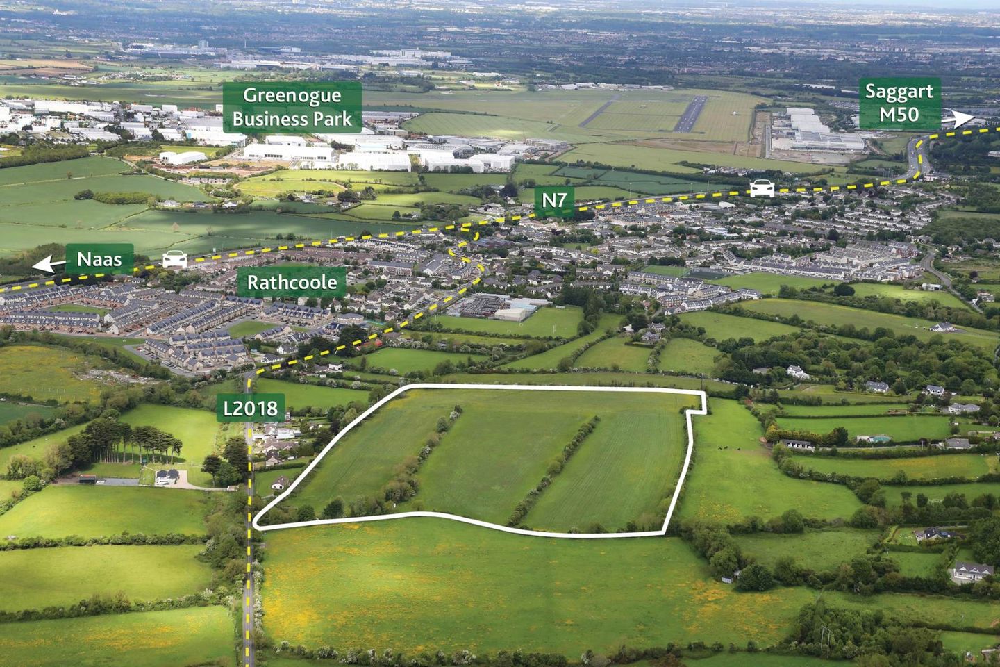
• Potential development land extending to approx. 23.5 acres (9.5 ha) • Located close to the boundary of the South County Dublin Development Plan 2022 2028 • Located in an area of huge potential growth on the edge of the expanding town of Rathcoole • Currently laid out in grass and well-maintained with mature hedgerow boundaries • Of interest to developers, investors and those seeking an investment with growth prospects Rathcoole 1km, M50 5km, Dublin Airport 20km Guide Price €1,175,000 Type of Transaction Private Treaty Location Rathcoole is a fast growing suburb of over 6,000 residents located about 16km southwest of Dublin city. The town is strategically located for growth thanks to its access to the N7, the Luas line at Saggart and the numerous Business Parks in the wider area, Most notable of which are the Greenogue Business Park, Aerodrome Business Park and the Citywest Business Campus. Access to the M50 motorway is less than a 10 minute drive away with Dublin Airport within a 30 minute drive away. Additional Information • Located close to proposed Western Dublin Orbital Route linking N81 to Leixlip Interchange • Close to the Luas stop at Saggart • Prime elevated free draining lands Viewing By appointment at any reasonable hour Directions From Dublin city centre, take the N7 and take Exit 4 marked for Rathcoole/Newcastle. Proceed for approx. 100m and take the left turn onto the Johnstown Road and continue for approx. 1.4km and the property is on the left hand side marked by a for sale sign. Contact Information: Philip Byrne T: 01 628 6128 E: philipb Accommodation Note: Please note we have not tested any apparatus, fixtures, fittings, or services. Interested parties must undertake their own investigation into the working order of these items. All measurements are approximate and photographs provided for guidance only.
The local area
The local area
Local schools and transport
Learn more about what this area has to offer.
School Name | Distance | Pupils | |||
|---|---|---|---|---|---|
| School Name | Holy Family National School | Distance | 1.2km | Pupils | 699 |
| School Name | Scoil Chronain | Distance | 1.7km | Pupils | 381 |
| School Name | St Mary's Saggart | Distance | 2.9km | Pupils | 673 |
School Name | Distance | Pupils | |||
|---|---|---|---|---|---|
| School Name | St Finian's Primary School | Distance | 3.2km | Pupils | 644 |
| School Name | City West Educate Together National School | Distance | 3.5km | Pupils | 378 |
| School Name | Citywest & Saggart Community National School | Distance | 3.5km | Pupils | 419 |
| School Name | Gaelscoil Lir | Distance | 3.5km | Pupils | 48 |
| School Name | Rathcoole Etns | Distance | 3.5km | Pupils | 119 |
| School Name | Brittas National School | Distance | 4.7km | Pupils | 77 |
| School Name | Saplings Special School | Distance | 4.9km | Pupils | 29 |
School Name | Distance | Pupils | |||
|---|---|---|---|---|---|
| School Name | Holy Family Community School | Distance | 700m | Pupils | 986 |
| School Name | Coláiste Pobail Fóla | Distance | 3.9km | Pupils | 658 |
| School Name | Mount Seskin Community College | Distance | 5.1km | Pupils | 327 |
School Name | Distance | Pupils | |||
|---|---|---|---|---|---|
| School Name | St Aidan's Community School | Distance | 5.2km | Pupils | 561 |
| School Name | Killinarden Community School | Distance | 5.9km | Pupils | 508 |
| School Name | St Marks Community School | Distance | 6.8km | Pupils | 924 |
| School Name | Deansrath Community College | Distance | 7.3km | Pupils | 425 |
| School Name | Adamstown Community College | Distance | 7.3km | Pupils | 980 |
| School Name | Old Bawn Community School | Distance | 7.8km | Pupils | 1032 |
| School Name | Moyle Park College | Distance | 8.0km | Pupils | 766 |
Type | Distance | Stop | Route | Destination | Provider | ||||||
|---|---|---|---|---|---|---|---|---|---|---|---|
| Type | Bus | Distance | 750m | Stop | School Road | Route | 69 | Destination | Poolbeg St | Provider | Dublin Bus |
| Type | Bus | Distance | 750m | Stop | School Road | Route | 69 | Destination | Conyngham Rd | Provider | Dublin Bus |
| Type | Bus | Distance | 750m | Stop | School Road | Route | 69n | Destination | Saggart | Provider | Nitelink, Dublin Bus |
Type | Distance | Stop | Route | Destination | Provider | ||||||
|---|---|---|---|---|---|---|---|---|---|---|---|
| Type | Bus | Distance | 750m | Stop | School Road | Route | 69x | Destination | Poolbeg St | Provider | Dublin Bus |
| Type | Bus | Distance | 750m | Stop | Holy Family Community School | Route | 69 | Destination | Rathcoole | Provider | Dublin Bus |
| Type | Bus | Distance | 750m | Stop | Holy Family Community School | Route | 69x | Destination | Rathcoole | Provider | Dublin Bus |
| Type | Bus | Distance | 750m | Stop | Holy Family Community School | Route | 69n | Destination | Saggart | Provider | Nitelink, Dublin Bus |
| Type | Bus | Distance | 1.0km | Stop | School Road | Route | 69 | Destination | Rathcoole | Provider | Dublin Bus |
| Type | Bus | Distance | 1.0km | Stop | School Road | Route | 69n | Destination | Saggart | Provider | Nitelink, Dublin Bus |
| Type | Bus | Distance | 1.0km | Stop | School Road | Route | 69x | Destination | Rathcoole | Provider | Dublin Bus |
Statistics
- 29/09/2025Entered
- 1,199Property Views
Daft ID: 522393887


Coonan Maynooth
+353 1 6286128