
+10
14
Derrineden, Waterville, Co. Kerry
Price on Application
87.11 ac
Agricultural Land
Property Overview
- Available From: Immediately
Description
- Sale Type: For Sale by Private Treaty
- Overall Floor Area: 87.11 ac
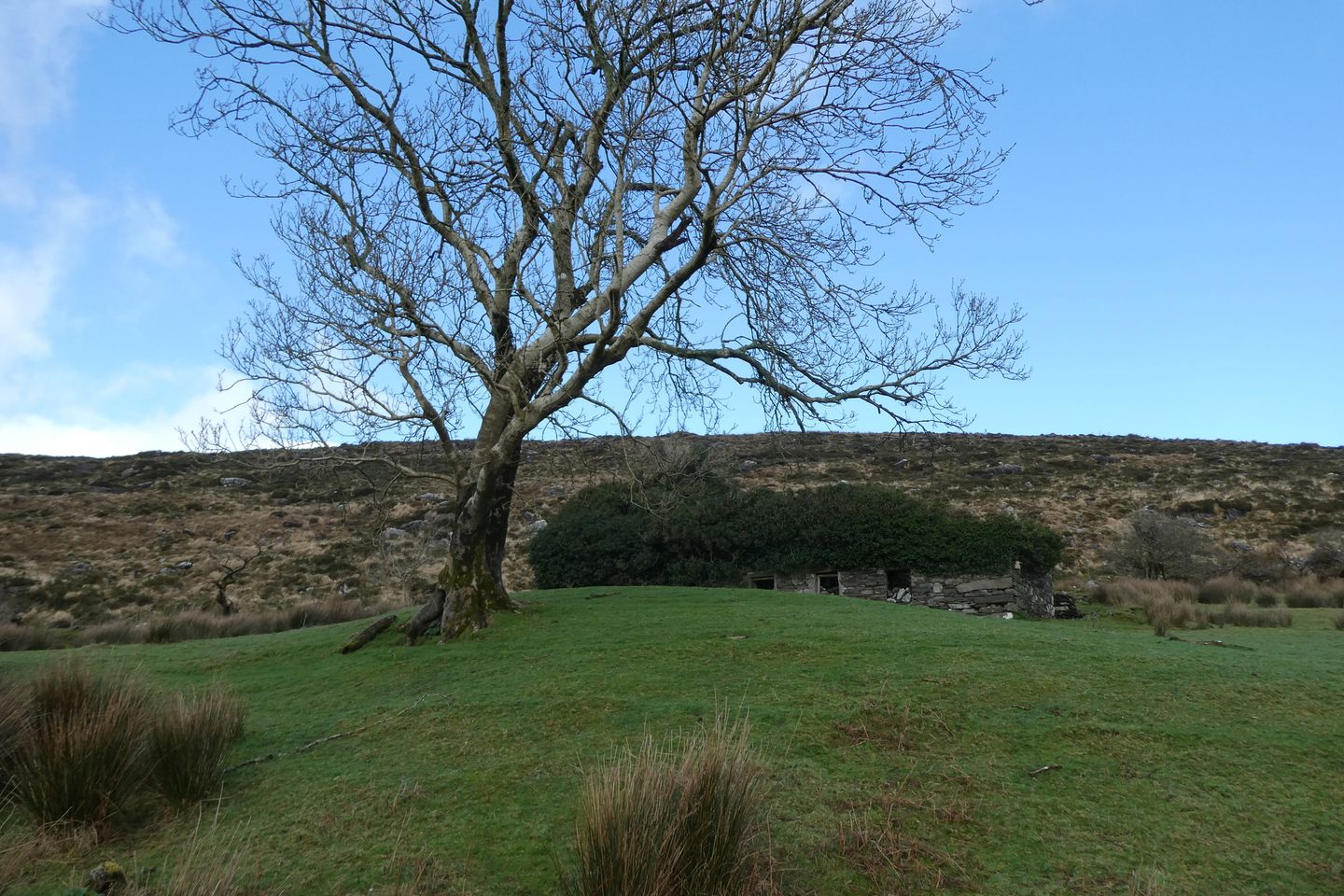
Set in a quiet rural location east of Waterville village is 35.25 Hectares/ 87.11 acres of agricultural land with stone ruin partly roofed at Derrineden., being 10KM to Waterville village. The land bounds both sides of the road, most of the land is around the stone ruin and onto the hill behind which bounds onto a secondary road above Mastergeehy old Post Office. Currently the land is being used for sheep grazing. There is a grassy road leading partly up to the land and stone ruin which could have potential for a dwelling house, from a planning permission point of view for the stone ruin it would be an advantage for the applicant to farm the land and it would need to be the applicant's primary place of residence in order to fulfil Kerry County Councils planning criteria to live in a rural area. There are lovely views across to Waterville Lake from the stone ruin and of the countryside. In addition there are 34.46 BPS entitlements including Greening being sold with the land.
Inviting offers.
Map
Map
Local AreaNEW

Learn more about what this area has to offer.
School Name | Distance | Pupils | |||
|---|---|---|---|---|---|
| School Name | S.n. Cillín Liath | Distance | 3.8km | Pupils | 41 |
| School Name | St Finian's National School Waterville | Distance | 7.4km | Pupils | 103 |
| School Name | Coars National School | Distance | 8.5km | Pupils | 34 |
School Name | Distance | Pupils | |||
|---|---|---|---|---|---|
| School Name | Aghatubrid National School | Distance | 10.2km | Pupils | 50 |
| School Name | Caherdaniel National School | Distance | 11.5km | Pupils | 53 |
| School Name | Filemore National School | Distance | 12.8km | Pupils | 54 |
| School Name | Caherciveen National School | Distance | 12.8km | Pupils | 158 |
| School Name | Sneem National School | Distance | 12.8km | Pupils | 69 |
| School Name | Sn Naomh Mhichil | Distance | 13.3km | Pupils | 48 |
| School Name | Scoil An Ghleanna | Distance | 17.1km | Pupils | 24 |
School Name | Distance | Pupils | |||
|---|---|---|---|---|---|
| School Name | Coláiste Na Sceilge | Distance | 13.1km | Pupils | 594 |
| School Name | Beara Community School | Distance | 27.7km | Pupils | 309 |
| School Name | Coláiste Íde | Distance | 32.0km | Pupils | 123 |
School Name | Distance | Pupils | |||
|---|---|---|---|---|---|
| School Name | Killorglin Community College | Distance | 32.5km | Pupils | 287 |
| School Name | Pobalscoil Chorca Dhuibhne | Distance | 32.5km | Pupils | 399 |
| School Name | The Intermediate School | Distance | 32.6km | Pupils | 596 |
| School Name | Pobalscoil Inbhear Scéine | Distance | 34.4km | Pupils | 570 |
| School Name | Presentation Secondary School | Distance | 39.3km | Pupils | 688 |
| School Name | Meanscoil Nua An Leith Triuigh | Distance | 42.7km | Pupils | 159 |
| School Name | St. Brigid's Presentation Secondary School | Distance | 44.0km | Pupils | 746 |
Type | Distance | Stop | Route | Destination | Provider | ||||||
|---|---|---|---|---|---|---|---|---|---|---|---|
| Type | Bus | Distance | 4.1km | Stop | Killeenleagh | Route | 287b | Destination | Dromid | Provider | Tfi Local Link Kerry |
| Type | Bus | Distance | 4.1km | Stop | Killeenleagh | Route | 287b | Destination | Cahersiveen | Provider | Tfi Local Link Kerry |
| Type | Bus | Distance | 4.1km | Stop | Killeenleagh | Route | 287b | Destination | Ballinskelligs | Provider | Tfi Local Link Kerry |
Type | Distance | Stop | Route | Destination | Provider | ||||||
|---|---|---|---|---|---|---|---|---|---|---|---|
| Type | Bus | Distance | 8.0km | Stop | Waterville | Route | 280 | Destination | Killorglin | Provider | Tfi Local Link Kerry |
| Type | Bus | Distance | 8.0km | Stop | Waterville | Route | 280 | Destination | Cahersiveen | Provider | Tfi Local Link Kerry |
| Type | Bus | Distance | 8.0km | Stop | Waterville | Route | 280 | Destination | Waterville | Provider | Tfi Local Link Kerry |
| Type | Bus | Distance | 8.0km | Stop | Waterville | Route | 280 | Destination | Killarney Bus Stn | Provider | Tfi Local Link Kerry |
| Type | Bus | Distance | 8.0km | Stop | Waterville | Route | 281 | Destination | Kenmare | Provider | Tfi Local Link Kerry |
| Type | Bus | Distance | 8.0km | Stop | Waterville | Route | 281 | Destination | Waterville | Provider | Tfi Local Link Kerry |
| Type | Bus | Distance | 11.0km | Stop | Castlecove | Route | 281 | Destination | Kenmare | Provider | Tfi Local Link Kerry |
BER Details

Statistics
08/03/2024
Entered/Renewed
3,042
Property Views
Daft ID: 515698976
Contact Agent

Pauline Sugrue
066 9474310