
Development Land at Laherdane, White's Cross, Co. Cork
Price on Application
- Selling Type:By Private Treaty
- Available From:Immediately
About this property
Description
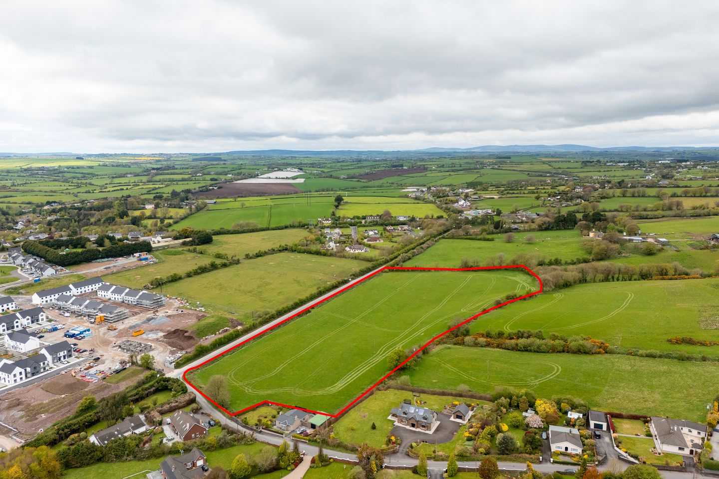
ERA Downey McCarthy are delighted to present to the market this outstanding development opportunity. Location The lands are located approximately 2km from Dunnes Stores shopping centre, Ballyvolane and are accessed via the R614 at the junction with Laherdane lane. Neighbouring occupiers are mainly agricultural but there is an established pattern of one off detached residential dwellings located on Laherdane lane. The new proposed northern distributor road will improve connectivity to the major road networks. There are 3 major residential developments underway nearby. Description The lands extend to c.4.31ha (c.10.65 acres) and are currently laid to pasture. Boundaries are well defined. The lands are currently comprised in a single field sloping gently to the Eastern perimeter. The lands are currently in agricultural use and have substantial road frontage extending to c. 270 meters. Zoning The lands are zoned ZO 9 "Light Industry and Related Uses" in the Cork City Development Plan 2022-2028. Likely permitted uses subject to planning permission include: Light industry, wholesale and non-retail trading uses, Car showrooms, Small/medium scale manufacturing/repairs/warehousing/distribution uses, Logistics and Incubator units. Retail warehousing and office development where not suited to town centre or edge of centre locations. Services Uisce Eireann have advised the existing Water and Waste Water infrastructure is sufficient for a low density development in response to a pre connection enquiry. Title The lands have a freehold title and are comprised in folio CK35348 Co Cork. Features Superb development opportunity subject to planning permission. Excellent road frontage. Attractive zoning suitable for a variety of potential uses. Freehold title. BER Details BER: Exempt Directions The lands are located at the junction of the Ballyhooly Road and Laherdane lane and immediately opposite the current Coppingers Field residential development.
The local area
The local area
Local schools and transport
Learn more about what this area has to offer.
School Name | Distance | Pupils | |||
|---|---|---|---|---|---|
| School Name | Scoil Oilibhéir | Distance | 1.4km | Pupils | 495 |
| School Name | St Killians Spec Sch | Distance | 2.4km | Pupils | 102 |
| School Name | S N Mharcuis B | Distance | 2.5km | Pupils | 88 |
School Name | Distance | Pupils | |||
|---|---|---|---|---|---|
| School Name | Upper Glanmire National School | Distance | 2.5km | Pupils | 291 |
| School Name | Cara Junior School | Distance | 2.5km | Pupils | 72 |
| School Name | Gaelscoil Peig Sayers | Distance | 2.6km | Pupils | 287 |
| School Name | St Brendan's Girls National School | Distance | 2.7km | Pupils | 110 |
| School Name | St Patrick's Girls National School | Distance | 2.8km | Pupils | 134 |
| School Name | Gaelscoil An Ghoirt Álainn | Distance | 2.8km | Pupils | 375 |
| School Name | St Patrick's Boys' School | Distance | 2.8km | Pupils | 166 |
School Name | Distance | Pupils | |||
|---|---|---|---|---|---|
| School Name | St. Aidan's Community College | Distance | 1.5km | Pupils | 329 |
| School Name | Mayfield Community School | Distance | 2.3km | Pupils | 345 |
| School Name | St Patricks College | Distance | 2.8km | Pupils | 201 |
School Name | Distance | Pupils | |||
|---|---|---|---|---|---|
| School Name | Nano Nagle College | Distance | 3.3km | Pupils | 136 |
| School Name | Gaelcholáiste Mhuire | Distance | 3.3km | Pupils | 683 |
| School Name | North Monastery Secondary School | Distance | 3.4km | Pupils | 283 |
| School Name | St Vincent's Secondary School | Distance | 3.5km | Pupils | 256 |
| School Name | Scoil Mhuire | Distance | 3.6km | Pupils | 429 |
| School Name | St. Angela's College | Distance | 3.6km | Pupils | 608 |
| School Name | Coláiste An Phiarsaigh | Distance | 4.0km | Pupils | 576 |
Type | Distance | Stop | Route | Destination | Provider | ||||||
|---|---|---|---|---|---|---|---|---|---|---|---|
| Type | Bus | Distance | 520m | Stop | White's Cross | Route | 248 | Destination | Glenville | Provider | Bus Éireann |
| Type | Bus | Distance | 570m | Stop | White's Cross | Route | 248 | Destination | Cork | Provider | Bus Éireann |
| Type | Bus | Distance | 1.0km | Stop | Brookwood | Route | 207 | Destination | Ballyvolane | Provider | Bus Éireann |
Type | Distance | Stop | Route | Destination | Provider | ||||||
|---|---|---|---|---|---|---|---|---|---|---|---|
| Type | Bus | Distance | 1.1km | Stop | Kinvara Avenue | Route | 207 | Destination | Ballyvolane | Provider | Bus Éireann |
| Type | Bus | Distance | 1.4km | Stop | Kempton Park | Route | 207 | Destination | Ballyvolane | Provider | Bus Éireann |
| Type | Bus | Distance | 1.6km | Stop | Glenheights Park | Route | 207a | Destination | Glenthorn | Provider | Bus Éireann |
| Type | Bus | Distance | 1.6km | Stop | Glenheights Park | Route | 207a | Destination | Merchants Quay | Provider | Bus Éireann |
| Type | Bus | Distance | 1.6km | Stop | Glenheights Park | Route | 207 | Destination | Ballyvolane | Provider | Bus Éireann |
| Type | Bus | Distance | 1.7km | Stop | Thorndale | Route | 207 | Destination | Ballyvolane | Provider | Bus Éireann |
| Type | Bus | Distance | 1.7km | Stop | Thorndale | Route | 248 | Destination | Cork | Provider | Bus Éireann |
BER Details
Statistics
- 25/09/2025Entered
- 1,619Property Views
Daft ID: 521566249