
Development Land c. 23 Acres, Ashbourne, Co. Meath
€5,750,000
- Selling Type:By Private Treaty
- Available From:Immediately
About Development Land c. 23 Acres, Ashbourne, Co. Meath
Description
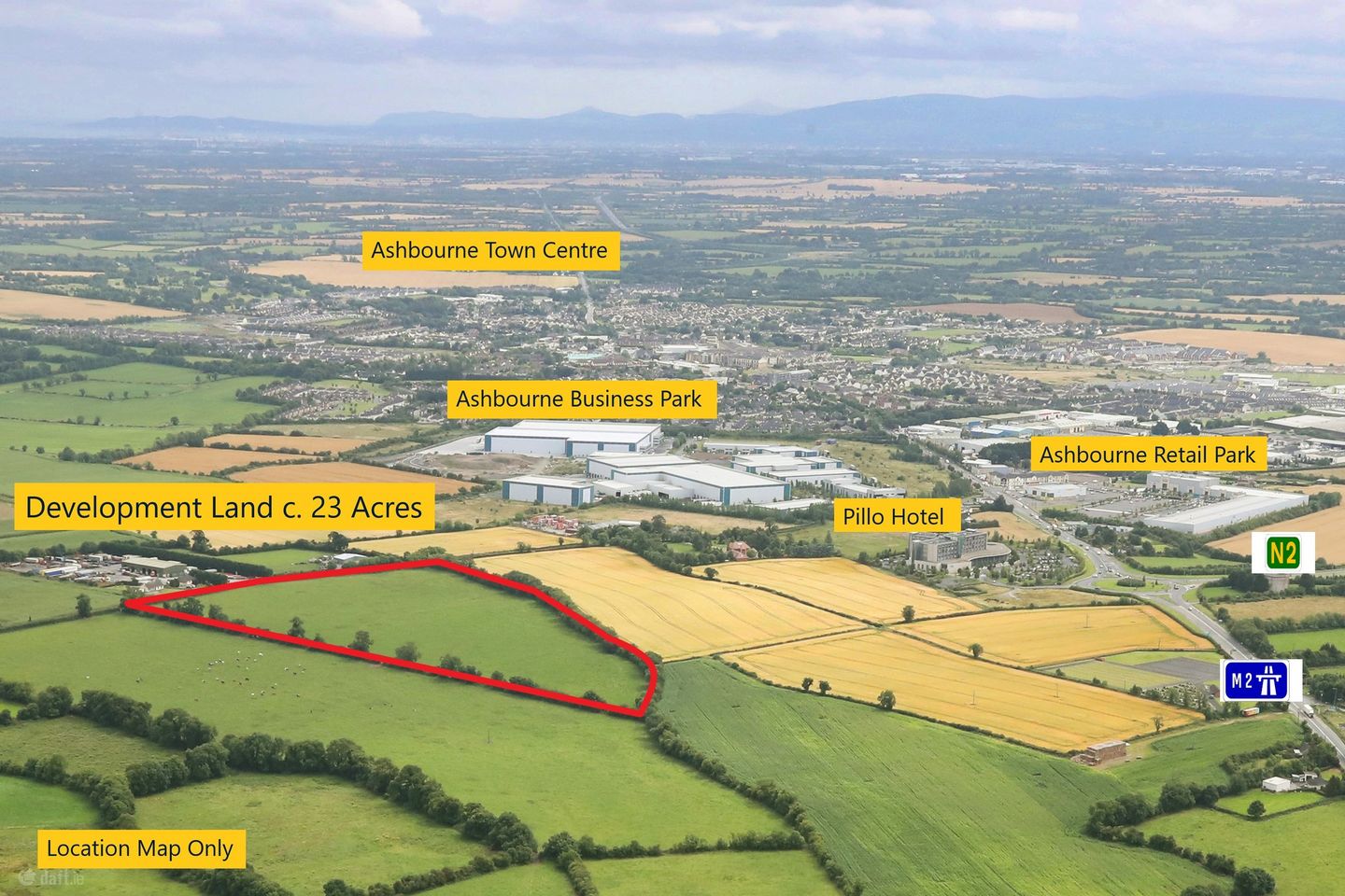
Situated fronting the Ballymaudan Road close to Ashbourne Business Park and the new M2 Interchange and Pillo Hotel, on the northern side of Ashbourne Town within Fingal County Council. Ashbourne town is located on the N2 National Primary route, approx. 23km from Dublin City Centre and approx. 19km from Dublin Airport. The site benefits from an easy link to the M50 via the M2 / Ashbourne bypass Motorway. This strategic zoned land has the benefit of being situated adjacent to the fast growing town of Ashbourne which offers a substantial local labour pool. The lands are within the Fingal County Council boundary. There is currently agricultural type access point, to the rear of the Pillo Hotel opposite the established Ashbourne Business Park on Garristown Road. Zoning Objective "GE" General Employment: Provide opportunities for general enterprise and employment. Vision: Facilitate opportunities for compatible industry and general employment uses, logistics and warehousing activity in a good quality physical environment. General Employment areas should be highly accessible, well designed, permeable and legible. This site represents an exceptional industrial development opportunity along one of Ireland main logistics corridors. - Well located industrial and logistics site of 23 acres (9.3 ha) - Highly accessible location with easy access to M2 and in turn the M50, Dublin Airport and Dublin Port Tunnel. - Zoned to accommodate General Employment which includes light industrial, logistics and warehousing The N2 corridor has a proven development track record with a high calibre of established parks including: Dublin Airport Logistics Park (DALP), North Park, North City Business Park, Northern Cross Business Park and Ashbourne Business Park. Given Fingal Logistics Park scale and accessibility there is a substantial opportunity to develop a world class logistics hub 10 minutes North of the M50 and 15 minutes North of Dublin Airport and Dublin Port Tunnel.
The local area of Development Land c. 23 Acres, Ashbourne, Co. Meath
Local schools and transport

Learn more about what this area has to offer.
School Name | Distance | Pupils | |||
|---|---|---|---|---|---|
| School Name | St Mary's National School | Distance | 1.6km | Pupils | 481 |
| School Name | Ashbourne Educate Together National School | Distance | 2.0km | Pupils | 410 |
| School Name | Ashbourne Community National School | Distance | 2.0km | Pupils | 303 |
School Name | Distance | Pupils | |||
|---|---|---|---|---|---|
| School Name | Gaelscoil Na Mí | Distance | 2.1km | Pupils | 283 |
| School Name | St Andrew's Curragha | Distance | 2.5km | Pupils | 112 |
| School Name | St Declan's National School Ashbourne | Distance | 2.7km | Pupils | 647 |
| School Name | Gaelscoil Na Cille | Distance | 3.1km | Pupils | 227 |
| School Name | Garristown National School | Distance | 4.0km | Pupils | 187 |
| School Name | St Paul's National School Ratoath | Distance | 4.2km | Pupils | 576 |
| School Name | Ratoath Senior National School | Distance | 4.8km | Pupils | 360 |
School Name | Distance | Pupils | |||
|---|---|---|---|---|---|
| School Name | De Lacy College | Distance | 2.1km | Pupils | 913 |
| School Name | Ashbourne Community School | Distance | 3.1km | Pupils | 1111 |
| School Name | Ratoath College | Distance | 4.7km | Pupils | 1112 |
School Name | Distance | Pupils | |||
|---|---|---|---|---|---|
| School Name | Coláiste Rioga | Distance | 8.9km | Pupils | 193 |
| School Name | Community College Dunshaughlin | Distance | 9.4km | Pupils | 1135 |
| School Name | Le Chéile Secondary School | Distance | 12.8km | Pupils | 959 |
| School Name | St. Peter's College | Distance | 13.0km | Pupils | 1227 |
| School Name | Loreto College Swords | Distance | 13.6km | Pupils | 632 |
| School Name | Swords Community College | Distance | 14.1km | Pupils | 930 |
| School Name | St. Finian's Community College | Distance | 14.1km | Pupils | 661 |
Type | Distance | Stop | Route | Destination | Provider | ||||||
|---|---|---|---|---|---|---|---|---|---|---|---|
| Type | Bus | Distance | 610m | Stop | Ashbourne Business Park | Route | 195 | Destination | Ballyboughal | Provider | Tfi Local Link Louth Meath Fingal |
| Type | Bus | Distance | 660m | Stop | Rath | Route | 193 | Destination | Stephen's Green Nth | Provider | Ashbourne Connect |
| Type | Bus | Distance | 660m | Stop | Rath | Route | 194 | Destination | Stephen's Green Nth | Provider | Ashbourne Connect |
Type | Distance | Stop | Route | Destination | Provider | ||||||
|---|---|---|---|---|---|---|---|---|---|---|---|
| Type | Bus | Distance | 660m | Stop | Rath | Route | 197 | Destination | Ashbourne | Provider | Go-ahead Ireland |
| Type | Bus | Distance | 660m | Stop | Rath | Route | 103x | Destination | Duleek | Provider | Bus Éireann |
| Type | Bus | Distance | 660m | Stop | Rath | Route | 105 | Destination | Drogheda | Provider | Bus Éireann |
| Type | Bus | Distance | 900m | Stop | Ballybin Road | Route | 105 | Destination | Parkway Station | Provider | Bus Éireann |
| Type | Bus | Distance | 900m | Stop | Ballybin Road | Route | 103 | Destination | Dublin | Provider | Bus Éireann |
| Type | Bus | Distance | 900m | Stop | Ballybin Road | Route | 103x | Destination | U C D Belfield | Provider | Bus Éireann |
| Type | Bus | Distance | 910m | Stop | Ashbourne Retail Park | Route | 193 | Destination | Ashbourne Fs | Provider | Ashbourne Connect |
BER Details
Ad performance
- Date listed11/02/2025
- Views4,891
Daft ID: 520833159