
3
Gorey Hill, Carnew Road and Kilnahue Lane, Gorey, Co. Wexford
Price on Application
38 ac
Development Land
Property Overview
- Available From: Immediately
Description
- Overall Floor Area: 38 ac
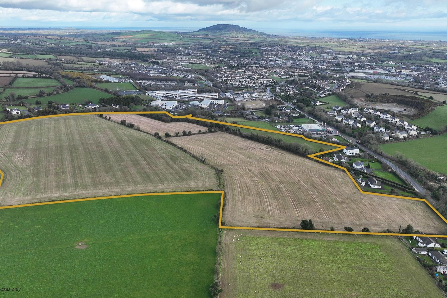
The entire holding extends to approx. 38 acres and benefits from frontage to both the Gorey-Carnew Road and Kilnahue Road.
The lands are zoned under the Gorey Town & Environs Local Area Plan 2017 – 2023. Approx. 31 acres are zoned Residential while the remaining approx. 7 acres are zoned Open Space and Amenity. In May 2022, Wexford County Council extended the duration of this LAP for a period of 3 years until 2026.
An SHD planning application (Bord Pleanála Case reference: TA26.313226) has been lodged on the lands for the construction of 421 no. residential units and creche. A decision on the application is now overdue from An Bord Pleanála.
There is also scope for an incoming purchaser to provide a revised scheme in line with the recently published Sustainable Residential Development and Compact Settlements Guidelines (s.p.p.).
The lands are situated directly opposite 3 schools - Gorey Educate Together National School, Creagh College and Gaelscoil Moshíológ. Furthermore, the lands are within walking distance of all the amenities of Gorey town.
Gorey Train Station provides commuter rail services to Dublin City centre. Also, Exit 23 of the M11 Motorway is a short drive away providing access to the wider motorway network.
Gorey has had a 14% population growth in the past six years according to the provisional population data from the 2022 Census. According to the data, the population of the Gorey Local Electoral Area (LEA) grew from 27,351 to 31,123 between 2016 and 2022, making it the fastest growing LEA in the county. The Gorey Local Electoral Area has almost the same population as the Wexford Local Electoral Area. The Census 2022 results show that Wexford has seen a rise to 163,527 or 9.2%.
Further information can be obtained from Jim Kinsella in Sherry FitzGerald O'Leary Kinsella or James Meagher / Finín O'Driscoll in Knight Frank.
Dataroom link: www.gorey-hill.com
Map
Map
Local AreaNEW

Learn more about what this area has to offer.
School Name | Distance | Pupils | |||
|---|---|---|---|---|---|
| School Name | Gorey Educate Together National School | Distance | 170m | Pupils | 393 |
| School Name | Gaelscoil Mhoshiolog | Distance | 240m | Pupils | 191 |
| School Name | Gorey Central School | Distance | 1.4km | Pupils | 214 |
School Name | Distance | Pupils | |||
|---|---|---|---|---|---|
| School Name | St Joseph's Primary School Gorey | Distance | 1.8km | Pupils | 528 |
| School Name | Bunscoil Loreto | Distance | 2.0km | Pupils | 647 |
| School Name | Craanford National School | Distance | 5.0km | Pupils | 153 |
| School Name | Kilanerin National School | Distance | 6.5km | Pupils | 201 |
| School Name | Riverchapel National School | Distance | 7.1km | Pupils | 313 |
| School Name | Monaseed National School | Distance | 7.2km | Pupils | 63 |
| School Name | Ballycanew National School | Distance | 7.3km | Pupils | 223 |
School Name | Distance | Pupils | |||
|---|---|---|---|---|---|
| School Name | Creagh College | Distance | 350m | Pupils | 995 |
| School Name | Gorey Educate Together Secondary School | Distance | 1.5km | Pupils | 100 |
| School Name | Gorey Community School | Distance | 2.2km | Pupils | 1532 |
School Name | Distance | Pupils | |||
|---|---|---|---|---|---|
| School Name | Coláiste Bhríde Carnew | Distance | 12.9km | Pupils | 957 |
| School Name | Glenart College | Distance | 16.6km | Pupils | 605 |
| School Name | Arklow Cbs | Distance | 17.1km | Pupils | 379 |
| School Name | Gaelcholáiste Na Mara | Distance | 17.3km | Pupils | 323 |
| School Name | St. Mary's College | Distance | 17.4km | Pupils | 539 |
| School Name | Coláiste An Átha | Distance | 18.3km | Pupils | 352 |
| School Name | F.c.j. Secondary School | Distance | 22.2km | Pupils | 1007 |
Type | Distance | Stop | Route | Destination | Provider | ||||||
|---|---|---|---|---|---|---|---|---|---|---|---|
| Type | Bus | Distance | 1.3km | Stop | Gorey District Hospital | Route | 389 | Destination | Gorey Shppng Ctr | Provider | Tfi Local Link Wexford |
| Type | Bus | Distance | 1.3km | Stop | Gorey District Hospital | Route | 389 | Destination | Gorey Hatch Lab | Provider | Tfi Local Link Wexford |
| Type | Bus | Distance | 1.3km | Stop | Gorey District Hospital | Route | 389 | Destination | Riverchapel | Provider | Tfi Local Link Wexford |
Type | Distance | Stop | Route | Destination | Provider | ||||||
|---|---|---|---|---|---|---|---|---|---|---|---|
| Type | Bus | Distance | 1.3km | Stop | Gorey Tesco Extra | Route | 389 | Destination | Riverchapel | Provider | Tfi Local Link Wexford |
| Type | Bus | Distance | 1.4km | Stop | Gorey Tesco Extra | Route | 389 | Destination | Gorey Shppng Ctr | Provider | Tfi Local Link Wexford |
| Type | Bus | Distance | 1.4km | Stop | Gorey Tesco Extra | Route | 389 | Destination | Gorey Hatch Lab | Provider | Tfi Local Link Wexford |
| Type | Bus | Distance | 1.6km | Stop | Gorey Shopping Cen | Route | 879 | Destination | Gorey Shopping Cen | Provider | Gorey Bus Links |
| Type | Bus | Distance | 1.6km | Stop | Gorey Shopping Cen | Route | 879 | Destination | Gorey | Provider | Gorey Bus Links |
| Type | Bus | Distance | 1.6km | Stop | Gorey Shopping Centre | Route | 389 | Destination | Riverchapel | Provider | Tfi Local Link Wexford |
| Type | Bus | Distance | 1.6km | Stop | Gorey | Route | 389 | Destination | Riverchapel | Provider | Tfi Local Link Wexford |
Statistics
30/04/2024
Entered/Renewed
188
Property Views
Daft ID: 519283846


Finín O'Driscoll
0860492114