

Kilmartin, Hollystown, Dublin 15, D15T95E
Price on Application
- Available From:Immediately
About this property
Description
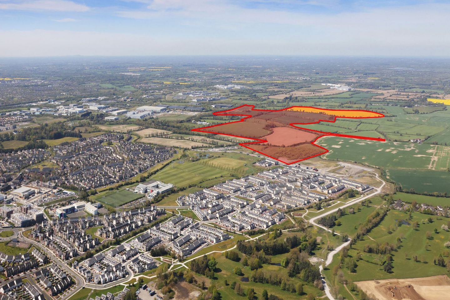
A large-scale strategic landholding at Kilmartin, Dublin 15, for sale by private treaty through joint agents Knight Frank and Lydon Farrell Property. The property presents a rare opportunity to acquire a substantial strategic land bank extending to approximately 268 acres (108.46 hectares) in a prime north west Dublin location. Large, single ownership holdings of this scale are exceptionally scarce within the Dublin area, making this a compelling long term opportunity for developers, investors and occupiers seeking a site of scale with strong accessibility and future growth potential. The eastern portion of the holding, comprised within Folios DN775 and DN141, extends to approximately 211.7 acres (85.7 hectares) and is predominantly zoned Objective RU – Rural under the Fingal County Development Plan 2023–2029. The western portion, comprised within Folio MH11417, extends to approximately 56 acres (22.7 hectares) and is zoned Objective RA – Rural Area under the Meath County Development Plan 2021–2027. The surrounding area has experienced significant growth over the past decade, with ongoing residential development at Kilmartin Grove, Tyrrelstown and Hollystown, immediately to the south of the lands. The area benefits from a strong educational offering, including St. Luke’s National School, Le Chéile Secondary School, Powerstown Educate Together, Gaelscoil an Chuilinn and TU Dublin, while Tyrrelstown village provides a range of amenities including Lidl, SuperValu and the Carlton Hotel. To the southwest, the wider area is characterised by established industrial and employment generating uses, with Damastown Industrial Park accommodating large scale industrial, logistics and high technology occupiers, including IBM, Meta, PayPal, Amazon, Bristol Myers Squibb and Astellas. Fingal County Council continues to record the strongest population growth of any local authority in Ireland, with a current population exceeding 330,000, making it the second most populous local authority in the State. This growth trajectory is accelerating, with Fingal’s population projected to increase by over 16 per cent by 2029, with further substantial growth anticipated over the following decades. The recent revision of the National Planning Framework, which has increased national housing delivery requirements to approximately 50,000 homes per annum to 2040, places well located strategic landholdings such as Kilmartin at the centre of future housing supply. The site’s strategic positioning, combined with sustained demand for residential and commercial land within the Dublin region, underpins its long term potential for rezoning or alternative uses through future county development plans. The location is highly accessible, with immediate access to the N2, N3 and the new N2/N3 Link Road, providing direct connectivity to the M3, M50 and the wider national road network. Dublin Airport is located approximately 13 kilometres to the east, with Dublin city centre readily accessible, reinforcing the area’s appeal as an established and emerging residential location. Opportunities of this strategic nature are increasingly scarce within the Greater Dublin Area, where population and employment growth continue to outpace the supply of zoned and serviced land at scale. This holding offers a unique opportunity to secure a long term strategic reserve capable of phased development, repositioning or long term investment, with strong potential to benefit from future planning cycles, rezoning initiatives and ongoing infrastructure investment within one of Ireland’s most dynamic growth corridors. Viewings by appointment
The local area
The local area
Local schools and transport

Learn more about what this area has to offer.
School Name | Distance | Pupils | |||
|---|---|---|---|---|---|
| School Name | Tyrrelstown Educate Together National School | Distance | 890m | Pupils | 482 |
| School Name | Powerstown Educate Together National School | Distance | 1.4km | Pupils | 331 |
| School Name | Saint Lukes National School | Distance | 1.4km | Pupils | 517 |
School Name | Distance | Pupils | |||
|---|---|---|---|---|---|
| School Name | Gaelscoil An Chuilinn | Distance | 1.4km | Pupils | 281 |
| School Name | Ladyswell National School | Distance | 2.4km | Pupils | 434 |
| School Name | Kilbride National School | Distance | 2.5km | Pupils | 306 |
| School Name | Sacred Heart Of Jesus National School Huntstown | Distance | 3.0km | Pupils | 661 |
| School Name | Mary Mother Of Hope Senior National School | Distance | 3.3km | Pupils | 429 |
| School Name | Scoil Mhuire Senior School | Distance | 3.4km | Pupils | 233 |
| School Name | St Patricks Senior School | Distance | 3.4km | Pupils | 205 |
School Name | Distance | Pupils | |||
|---|---|---|---|---|---|
| School Name | Le Chéile Secondary School | Distance | 1.6km | Pupils | 959 |
| School Name | Rath Dara Community College | Distance | 3.0km | Pupils | 297 |
| School Name | Blakestown Community School | Distance | 3.6km | Pupils | 521 |
School Name | Distance | Pupils | |||
|---|---|---|---|---|---|
| School Name | Hartstown Community School | Distance | 3.8km | Pupils | 1124 |
| School Name | Scoil Phobail Chuil Mhin | Distance | 4.3km | Pupils | 1013 |
| School Name | Colaiste Pobail Setanta | Distance | 4.4km | Pupils | 1069 |
| School Name | Edmund Rice College | Distance | 4.4km | Pupils | 813 |
| School Name | St. Peter's College | Distance | 5.2km | Pupils | 1227 |
| School Name | Hansfield Etss | Distance | 5.3km | Pupils | 847 |
| School Name | Eriu Community College | Distance | 5.9km | Pupils | 194 |
Type | Distance | Stop | Route | Destination | Provider | ||||||
|---|---|---|---|---|---|---|---|---|---|---|---|
| Type | Bus | Distance | 640m | Stop | Mount Garrett | Route | 236 | Destination | Dublin Tech Campus | Provider | Go-ahead Ireland |
| Type | Bus | Distance | 640m | Stop | Mount Garrett | Route | 236t | Destination | Scoil Oilibheir | Provider | Go-ahead Ireland |
| Type | Bus | Distance | 640m | Stop | Mount Garrett | Route | 238 | Destination | Carlton Hotel | Provider | Go-ahead Ireland |
Type | Distance | Stop | Route | Destination | Provider | ||||||
|---|---|---|---|---|---|---|---|---|---|---|---|
| Type | Bus | Distance | 640m | Stop | Mount Garrett | Route | 236a | Destination | Blanchardstown | Provider | Go-ahead Ireland |
| Type | Bus | Distance | 660m | Stop | Mount Garrett | Route | 40d | Destination | Parnell St | Provider | Dublin Bus |
| Type | Bus | Distance | 660m | Stop | Mount Garrett | Route | 40e | Destination | Broombridge Luas | Provider | Dublin Bus |
| Type | Bus | Distance | 760m | Stop | Mount Eustace | Route | 238 | Destination | Mulhuddart | Provider | Go-ahead Ireland |
| Type | Bus | Distance | 760m | Stop | Mount Eustace | Route | 40d | Destination | Parnell St | Provider | Dublin Bus |
| Type | Bus | Distance | 760m | Stop | Mount Eustace | Route | 40e | Destination | Broombridge Luas | Provider | Dublin Bus |
| Type | Bus | Distance | 760m | Stop | Mount Eustace | Route | 236a | Destination | Blanchardstown | Provider | Go-ahead Ireland |
A closer look
Ad performance
- Date listed29/04/2026
- Views70
Daft ID: 56556776