Land at Mill Road, Corbally, Co. Limerick
Price on Application
- Available From:Immediately
About this property
Description
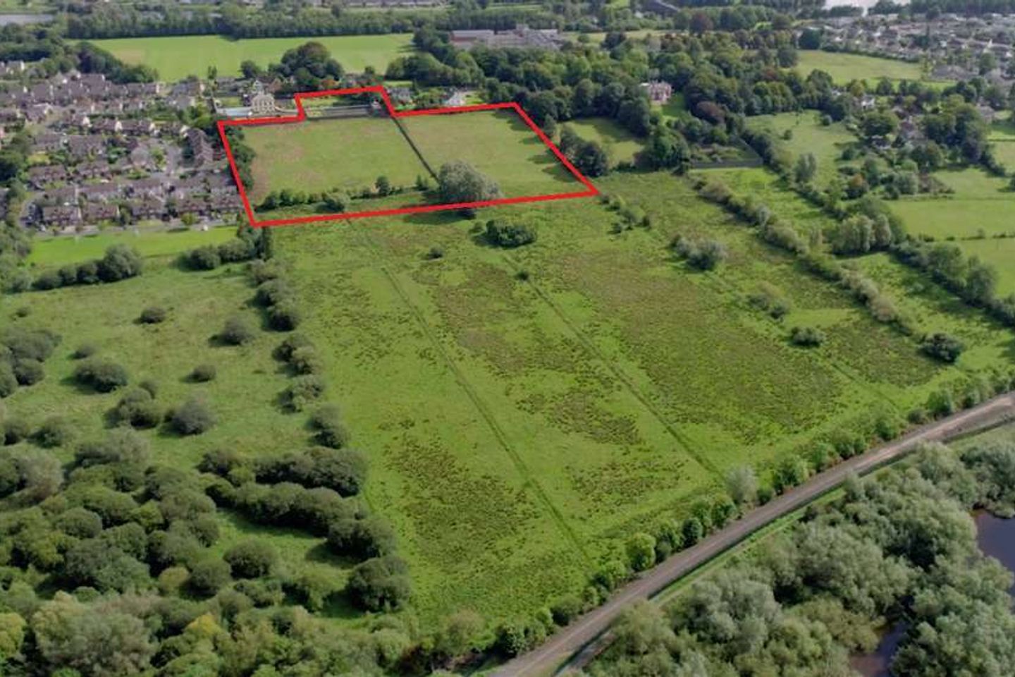
Superb Residential Development Opportunity for sale by way of best bids, excellently located within close proximity of Limerick city centre. The subject property in its entirety has a site area of approximately 7 acres. The land and benefits from a new access point and has extensive frontage to the Mill Road, approximately 105 metres. The land which slopes gradually from east to west benefits from a mature tree line which runs along each boundary providing the upmost of privacy, while a large stone constructed wall acts as a boundary along the north and eastern boundaries providing further seclusion. The surrounding area is a mix of mature residential estate type developments such as Brookhaven and The Hermitage to the north and mature agricultural landholdings located to the west and to the south. Land at Mill Road is an exclusive area within the Corbally district of Limerick approximately 3km north of Limerick City Centre. The property which is located in one of Limerick's most desireable residential addresses is accessed via Corbally Road which links the Mill Road to the city centre. Corbally has long been a popular residential location amongst commuters given its ease of access and proximity to the city centre while also offering a high-quality living environment. The area benefits from 2 primary schools and 2 secondary schools. Grove Island Shopping complex which occupies large retailers such as Super Valu and Llyod's Pharmacy is located a mere 750 meters to the south.
The local area
The local area
Local schools and transport

Learn more about what this area has to offer.
School Name | Distance | Pupils | |||
|---|---|---|---|---|---|
| School Name | Scoil Íde | Distance | 620m | Pupils | 690 |
| School Name | Parteen National School | Distance | 1.4km | Pupils | 303 |
| School Name | St Mary's National School | Distance | 1.5km | Pupils | 140 |
School Name | Distance | Pupils | |||
|---|---|---|---|---|---|
| School Name | Thomond Primary School | Distance | 1.7km | Pupils | 215 |
| School Name | Gaelscoil Sairseal | Distance | 1.8km | Pupils | 343 |
| School Name | Corpus Christi National School | Distance | 1.8km | Pupils | 415 |
| School Name | St Patrick's Girls National School Limerick | Distance | 2.1km | Pupils | 201 |
| School Name | St John The Baptist Boys National School | Distance | 2.2km | Pupils | 47 |
| School Name | Scoil Padraig Naof B | Distance | 2.3km | Pupils | 207 |
| School Name | Salesian Primary School | Distance | 2.3km | Pupils | 389 |
School Name | Distance | Pupils | |||
|---|---|---|---|---|---|
| School Name | St Munchin's College | Distance | 310m | Pupils | 662 |
| School Name | Gaelcholáiste Luimnigh | Distance | 1.8km | Pupils | 616 |
| School Name | Thomond Community College | Distance | 2.1km | Pupils | 606 |
School Name | Distance | Pupils | |||
|---|---|---|---|---|---|
| School Name | Ardscoil Ris | Distance | 2.5km | Pupils | 747 |
| School Name | Limerick City East Secondary School | Distance | 2.5km | Pupils | 714 |
| School Name | Coláiste Nano Nagle | Distance | 2.5km | Pupils | 356 |
| School Name | Colaiste Mhichil | Distance | 2.6km | Pupils | 346 |
| School Name | St Clements College | Distance | 3.3km | Pupils | 411 |
| School Name | Laurel Hill Coláiste Fcj | Distance | 3.4km | Pupils | 343 |
| School Name | Laurel Hill Secondary School Fcj | Distance | 3.4km | Pupils | 725 |
Type | Distance | Stop | Route | Destination | Provider | ||||||
|---|---|---|---|---|---|---|---|---|---|---|---|
| Type | Bus | Distance | 520m | Stop | Riverside Drive | Route | 301 | Destination | Westbury | Provider | Bus Éireann |
| Type | Bus | Distance | 550m | Stop | Athlunkard Bridge | Route | 301 | Destination | O'Connell Street | Provider | Bus Éireann |
| Type | Bus | Distance | 550m | Stop | Athlunkard Bridge | Route | 301 | Destination | Father Russell Road | Provider | Bus Éireann |
Type | Distance | Stop | Route | Destination | Provider | ||||||
|---|---|---|---|---|---|---|---|---|---|---|---|
| Type | Bus | Distance | 570m | Stop | Athlunkard Bridge | Route | 301 | Destination | Westbury | Provider | Bus Éireann |
| Type | Bus | Distance | 580m | Stop | Riverside Park | Route | 301 | Destination | Westbury | Provider | Bus Éireann |
| Type | Bus | Distance | 680m | Stop | Shannon Grove | Route | 301 | Destination | Westbury | Provider | Bus Éireann |
| Type | Bus | Distance | 730m | Stop | Mill Road | Route | 301 | Destination | Westbury | Provider | Bus Éireann |
| Type | Bus | Distance | 730m | Stop | Mill Road | Route | 301 | Destination | O'Connell Street | Provider | Bus Éireann |
| Type | Bus | Distance | 730m | Stop | Mill Road | Route | 301 | Destination | Father Russell Road | Provider | Bus Éireann |
| Type | Bus | Distance | 740m | Stop | Athlunkard Avenue | Route | 301 | Destination | Westbury | Provider | Bus Éireann |
Statistics
- 11/11/2025Entered
- 2,962Property Views
Daft ID: 520331509