
Lands at Tay Lane, Rathcoole, Co. Dublin
Price on Application
44192 m²Industrial Site
- Available From:Immediately
About this property
Description
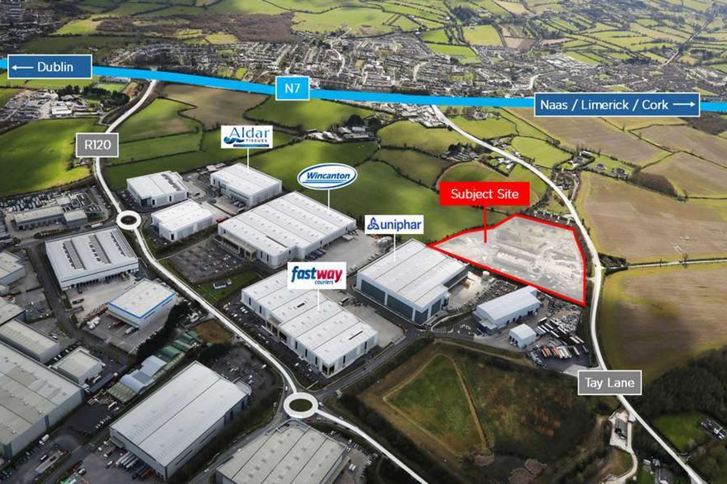
Excellent Developer / Owner Occupier Opportunity with the benefit of full planning permission for 6 industrial units extending to 170,776 sq. ft. Rare opportunity to acquire a prime industrial site with excellent connectivity. Regular shaped site extending to10.92 acres. Zoned for Enterprise & Employment, facilitating a wide range of user types. Benefits from Full Planning Permission. The subject site is well located off Tay Lane in Rathcoole. The site is situated approx. 2.3km north of the N7 / Rathcoole Junction, providing access to the M50 (approx. 9km). The site's proximity to the N7 allows for access to both Dublin Port (approx. 34km) and Dublin Airport (approx. 28km).
The local area
The local area
Local schools and transport

Learn more about what this area has to offer.
School Name | Distance | Pupils | |||
|---|---|---|---|---|---|
| School Name | Holy Family National School | Distance | 920m | Pupils | 699 |
| School Name | Scoil Chronain | Distance | 980m | Pupils | 381 |
| School Name | St Finian's Primary School | Distance | 2.0km | Pupils | 644 |
School Name | Distance | Pupils | |||
|---|---|---|---|---|---|
| School Name | St Mary's Saggart | Distance | 2.5km | Pupils | 673 |
| School Name | City West Educate Together National School | Distance | 2.6km | Pupils | 378 |
| School Name | Citywest & Saggart Community National School | Distance | 2.6km | Pupils | 419 |
| School Name | Gaelscoil Lir | Distance | 2.6km | Pupils | 48 |
| School Name | Rathcoole Etns | Distance | 2.7km | Pupils | 119 |
| School Name | St Aidan's National School | Distance | 4.8km | Pupils | 244 |
| School Name | St Brigids Brookfield | Distance | 4.9km | Pupils | 212 |
School Name | Distance | Pupils | |||
|---|---|---|---|---|---|
| School Name | Holy Family Community School | Distance | 1.3km | Pupils | 986 |
| School Name | Coláiste Pobail Fóla | Distance | 2.9km | Pupils | 658 |
| School Name | St Aidan's Community School | Distance | 4.3km | Pupils | 561 |
School Name | Distance | Pupils | |||
|---|---|---|---|---|---|
| School Name | Mount Seskin Community College | Distance | 4.6km | Pupils | 327 |
| School Name | Adamstown Community College | Distance | 5.4km | Pupils | 980 |
| School Name | Deansrath Community College | Distance | 5.5km | Pupils | 425 |
| School Name | Killinarden Community School | Distance | 5.5km | Pupils | 508 |
| School Name | St Marks Community School | Distance | 5.9km | Pupils | 924 |
| School Name | Griffeen Community College | Distance | 6.3km | Pupils | 537 |
| School Name | Kishoge Community College | Distance | 6.3km | Pupils | 925 |
Type | Distance | Stop | Route | Destination | Provider | ||||||
|---|---|---|---|---|---|---|---|---|---|---|---|
| Type | Bus | Distance | 520m | Stop | Greenogue Rdbt | Route | W6 | Destination | Community College | Provider | Go-ahead Ireland |
| Type | Bus | Distance | 540m | Stop | Greenogue Rdbt | Route | W6 | Destination | The Square | Provider | Go-ahead Ireland |
| Type | Bus | Distance | 590m | Stop | Tay Lane | Route | W6 | Destination | The Square | Provider | Go-ahead Ireland |
Type | Distance | Stop | Route | Destination | Provider | ||||||
|---|---|---|---|---|---|---|---|---|---|---|---|
| Type | Bus | Distance | 590m | Stop | Tay Lane | Route | 69n | Destination | Saggart | Provider | Nitelink, Dublin Bus |
| Type | Bus | Distance | 590m | Stop | Tay Lane | Route | 68 | Destination | Greenogue | Provider | Dublin Bus |
| Type | Bus | Distance | 610m | Stop | Grants Row | Route | 68 | Destination | Poolbeg St | Provider | Dublin Bus |
| Type | Bus | Distance | 650m | Stop | Greenogue Ie | Route | W6 | Destination | Community College | Provider | Go-ahead Ireland |
| Type | Bus | Distance | 690m | Stop | Tay Lane | Route | 68 | Destination | Poolbeg St | Provider | Dublin Bus |
| Type | Bus | Distance | 690m | Stop | Tay Lane | Route | W6 | Destination | Community College | Provider | Go-ahead Ireland |
| Type | Bus | Distance | 730m | Stop | Grants Row | Route | 68 | Destination | Greenogue | Provider | Dublin Bus |
Statistics
- 11/11/2025Entered
- 1,728Property Views
Daft ID: 521787546