
Lower Park, Corbally, Limerick, Co. Limerick
Price on Application
- Available From:Immediately
About this property
Description
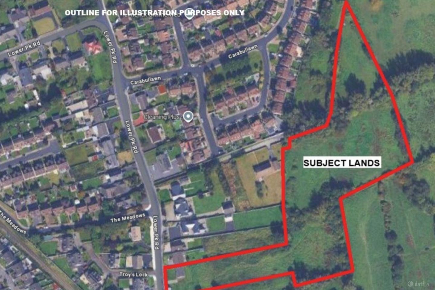
GVM welcome to the market this circa 5 st acre land holding with an approx. 1 acre development site benefiting from full planning permission for the construction of a high quality 15-unit residential scheme. Located in a desirable and accessible area, the site benefits from full planning consent and presents a shovel ready opportunity for developers and builders. The approved plans provide for a well-considered mix of 15 homes, tailored to meet strong local housing demand. There are also 4 acres of un-zoned agricultural land attached which enhances the residential planning aspect. Further details and plans can be found under Planning Reference number 2460864. The lands can be sold separately ie. Lot 1 - Development site of approx. 1 acre. Lot 2 - Agricultural lands of approx. 4 acres. The Location Located in the highly regarded Lower Park area of Corbally, this site enjoys a superb setting within one of Limericks most desirable residential suburbs wiith convenient access to Limerick City Centre. Lower Park offers the perfect balance of tranquil suburban living with proximity to an abundance of amenities. FULL PLANNING PERMISSION GRANTED PLANNING REF. 2460864 RESIDENTIAL DEVELOPMENT COMPRISING 15 NO. UNITS: RENOVATION OF EXISTING BUNGALOW 1 NO. DETACHED RESIDENCE 2 NO. SEMI-DETACHED 2 NO. END OF TERRACE 1 NO MID-TERRACE 4 NO. 1 BED GROUND FLOOR APTS. 4 NO. TWO STOREY DUPLEXES EXCELLENT LOCATION WALKING DISTANCE TO AMENITIES EAST/WEST FACING CONDUCIVE TO SOLAR ELECTRIC HOUSES WITH PARKING SPACE AND PRIVATE GARDENS APARTMENTS HAVING PARKING SPACE & PRIVATE OUTDOOR AMENITY SPACE DUPLEXES WITH PARKING SPACE, SUN TERRACE & SECURE BIKE STORAGE Notice Please note we have not tested any apparatus, fixtures, fittings, or services. Interested parties must undertake their own investigation into the working order of these items. All measurements are approximate and photographs provided for guidance only.
The local area
The local area
Local schools and transport

Learn more about what this area has to offer.
School Name | Distance | Pupils | |||
|---|---|---|---|---|---|
| School Name | Scoil Íde | Distance | 480m | Pupils | 690 |
| School Name | St Mary's National School | Distance | 1.3km | Pupils | 140 |
| School Name | Parteen National School | Distance | 1.5km | Pupils | 303 |
School Name | Distance | Pupils | |||
|---|---|---|---|---|---|
| School Name | Gaelscoil Sairseal | Distance | 1.6km | Pupils | 343 |
| School Name | Thomond Primary School | Distance | 1.6km | Pupils | 215 |
| School Name | Corpus Christi National School | Distance | 1.8km | Pupils | 415 |
| School Name | St Patrick's Girls National School Limerick | Distance | 2.0km | Pupils | 201 |
| School Name | St John The Baptist Boys National School | Distance | 2.1km | Pupils | 47 |
| School Name | Scoil Padraig Naof B | Distance | 2.1km | Pupils | 207 |
| School Name | St Augustine's School | Distance | 2.2km | Pupils | 24 |
School Name | Distance | Pupils | |||
|---|---|---|---|---|---|
| School Name | St Munchin's College | Distance | 290m | Pupils | 662 |
| School Name | Ardscoil Mhuire | Distance | 1.3km | Pupils | 574 |
| School Name | Gaelcholáiste Luimnigh | Distance | 1.7km | Pupils | 616 |
School Name | Distance | Pupils | |||
|---|---|---|---|---|---|
| School Name | Thomond Community College | Distance | 2.1km | Pupils | 606 |
| School Name | Ardscoil Ris | Distance | 2.4km | Pupils | 747 |
| School Name | Limerick Educate Together Secondary School | Distance | 2.4km | Pupils | 714 |
| School Name | Coláiste Nano Nagle | Distance | 2.4km | Pupils | 356 |
| School Name | Colaiste Mhichil | Distance | 2.5km | Pupils | 346 |
| School Name | St Clements College | Distance | 3.2km | Pupils | 411 |
| School Name | Laurel Hill Coláiste Fcj | Distance | 3.2km | Pupils | 343 |
Type | Distance | Stop | Route | Destination | Provider | ||||||
|---|---|---|---|---|---|---|---|---|---|---|---|
| Type | Bus | Distance | 480m | Stop | Athlunkard Bridge | Route | 301 | Destination | Father Russell Road | Provider | Bus Éireann |
| Type | Bus | Distance | 520m | Stop | Athlunkard Bridge | Route | 345 | Destination | Scarrif | Provider | Bus Éireann |
| Type | Bus | Distance | 570m | Stop | Riverside Drive | Route | 301 | Destination | Westbury | Provider | Bus Éireann |
Type | Distance | Stop | Route | Destination | Provider | ||||||
|---|---|---|---|---|---|---|---|---|---|---|---|
| Type | Bus | Distance | 590m | Stop | Mill Road | Route | 301 | Destination | Father Russell Road | Provider | Bus Éireann |
| Type | Bus | Distance | 660m | Stop | Riverside Park | Route | 301 | Destination | Westbury | Provider | Bus Éireann |
| Type | Bus | Distance | 730m | Stop | Shannon Grove | Route | 301 | Destination | Westbury | Provider | Bus Éireann |
| Type | Bus | Distance | 780m | Stop | Saint Ita's Street North | Route | 305a | Destination | St. Mary's Park | Provider | Bus Éireann |
| Type | Bus | Distance | 800m | Stop | Athlunkard Avenue | Route | 301 | Destination | Westbury | Provider | Bus Éireann |
| Type | Bus | Distance | 800m | Stop | Shannon Banks | Route | 313 | Destination | Ardnacrusha | Provider | Bus Éireann |
| Type | Bus | Distance | 800m | Stop | Shannon Banks | Route | 301 | Destination | Westbury | Provider | Bus Éireann |
Ad performance
- Date listed08/12/2025
- Views1,597
Daft ID: 56451770