
Mountmellick Road, Portlaoise, Co. Laois, R32HEF4
€2,950,000
- Selling Type:By Private Treaty
- Available From:Immediately
About Mountmellick Road, Portlaoise, Co. Laois
Description
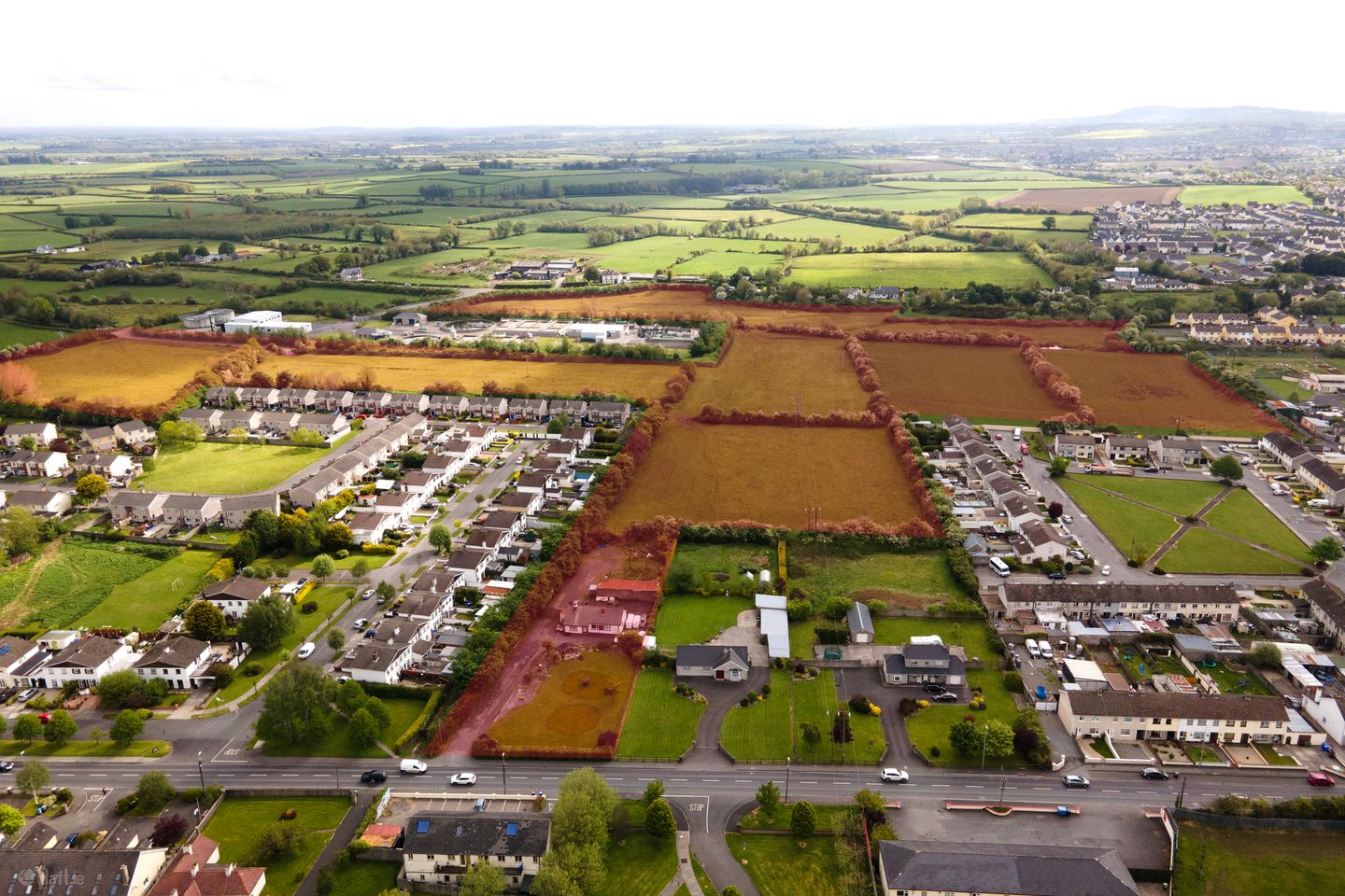
Development Land For Sale - 32.52 acres (13.16 hectares). High profile Development Site comprising of circa 13.16 hectares (c. 32.5 acres) for sale by private treaty. Gaynor Miller is delighted to offer to the market, one of the last remaining sizeable land-banks that is suitable for development, in such close proximity to Portlaoise town centre. Such an opportunity to purchase a large and strategically located development site in Laois rarely comes to the market like this. The subject property offers developers, state agencies and investors alike, the potential to develop a key block of lands, which is primarily zoned for new residential and transport & utility uses, easily accessible and all mains services available (subject to the necessary planning consents). Description: Development site extending to a total area of circa 13.16 hectares (c. 32.5 acres) Consists of a single-storey dwelling and outbuildings on a greenfield site, adjoined by a number of established residential estates and Portlaoise waste water treatment plant. The majority of the site (except the dwelling house and it's curtilage) is currently in grass, being used for agricultural purposes and its' topography is relatively flat throughout. The site is naturally divided into seven distinct fields by existing hedgerows and the river triogue traverses it. The site has the benefit of dual access from the N80 (well within the 50km/h speed limit zone) to the west and the Ridge Road to the east. No planning permission currently in place. Being sold with vacant possession. Services: All interested parties are required to satisfy themselves on the availability and adequacy of all services. It is our understanding that the subject landholding has access to mains sewerage, water, electricity and telecoms. Location: Superb development potential, as its' well located within walking distance of the town's plentiful businesses, amenities and general services. Situated between the N80 Mountmellick and Ridge roads in Portlaoise, this site is approximately 1km from the heart of the town, 85km from Dublin, 120km from Limerick City, 175km from Cork City and 55km from Kilkenny City. GPS coordinates for the site are 53.043527, -7.310933. Portlaoise is the largest town in County Laois with a population including environs in the region of 25,000 and increasing each year. It is one of the fastest growing towns in Ireland, with multiple state agency employers in situ, such as the Dept. of Agriculture, Portlaoise and Midlands Prisons, Portlaoise General Hospital, Laois County Council, Portlaoise Garda Station etc. The IDA Business Park, J17 National Enterprise Park and Clonminam Industrial Area in Togher also provide for additional employment through private entities established there. There is substantial public transport infrastructure in place in Portlaoise with the M7 (Dublin to Limerick/ Cork) motorway situated to the south of Portlaoise with easy access at three different junction points, the N80 passes through the centre of town (subject site has access onto this road) providing accessibility to the west of Ireland via Tullamore and south east via Carlow. Zoning Status: This prime, fully serviced block of lands have the benefit of mixed use zoning, primarily for residential and transport/ utility uses, as per the recently adopted Laois County Development Plan 2021 - 2027. c. 5.46 hectares (c. 13.5 acres) of Residential 2 - New Proposed Residential c. 6.7 hectares (c. 16.6 acres) of Transport & Utilities c. 1 hectare (c. 2.5 acres) of un-zoned lands (suitable for future development in line with the surrounding area subject to the required planning permission being achieved). Land Use Zoning: Residential 2 - New Proposed Residential Objective: To provide for new residential development, residential services and community facilities. Purpose: This zone is intended primarily for housing development but may include a range of other uses particularly those that have the potential to facilitate the development of new residential communities such as open space, schools, cré¨ches, small shops, doctor's surgeries, playing fields etc. It is an objective on land zoned for residential 2 to promote development mainly for housing, associated open space, community uses and where an acceptable standard of amenity can be maintained, a limited range of other uses that support the overall residential function of the area. Within this zoning category the improved quality of residential areas and the servicing of orderly development will be the Council's priority. New housing and infill developments should be of sensitive design, which are complementary to their surroundings. No piecemeal development can take place unless it does not conflict with the possible future development of the reserved development areas of the town. Adequate undeveloped lands have been zoned in the Plan for residential use to meet the requirements for both public and private house building over the Plan period. Transport & Utilities Objective: To provide for the needs of all transport users and other utility providers. Purpose: Car parks and commercial development associated with the provision of public transport services are considered appropriate in this zoning. This zoning also provides for and preserves land in the ownership of the Council or other bodies charged with the provision of services such as electricity, telecommunications, water, wastewater etc. to the town. Full details and all appointments to view the property, please contact Paul Gaynor @ 086 8192172 or by email. NOTE: These particulars are not to be considered a formal offer. They are for information only and give a general idea of the property. They are not to be taken as forming any part of a resulting contract, nor to be relied upon as statements or representations of fact. Whilst every care is taken in their preparation, neither Gaynor Miller Ltd. nor the vendor accept any liability as to their accuracy. Intending purchasers must satisfy themselves by personal inspection or otherwise as to the correctness of these particulars. No person in the employment of Gaynor Miller Ltd. has any authority to make or give any representation or warranty whatever in relation to this property.
The local area of Mountmellick Road, Portlaoise, Co. Laois
Local schools and transport

Learn more about what this area has to offer.
School Name | Distance | Pupils | |||
|---|---|---|---|---|---|
| School Name | Scoil Bhride National School | Distance | 720m | Pupils | 737 |
| School Name | Gaelscoil Phort Laoise | Distance | 1.0km | Pupils | 376 |
| School Name | Portlaoise Educate Together National School | Distance | 1.1km | Pupils | 464 |
School Name | Distance | Pupils | |||
|---|---|---|---|---|---|
| School Name | Maryborough National School | Distance | 1.6km | Pupils | 93 |
| School Name | Portlaoise S S | Distance | 1.8km | Pupils | 119 |
| School Name | Portlaoise Primary School | Distance | 2.6km | Pupils | 601 |
| School Name | Holy Family Senior School | Distance | 2.6km | Pupils | 643 |
| School Name | The Kolbe Special School | Distance | 2.6km | Pupils | 44 |
| School Name | Barr Na Sruthan | Distance | 5.9km | Pupils | 83 |
| School Name | Fraoch Mor National School | Distance | 6.0km | Pupils | 214 |
School Name | Distance | Pupils | |||
|---|---|---|---|---|---|
| School Name | Portlaoise College | Distance | 900m | Pupils | 952 |
| School Name | Dunamase College (coláiste Dhún Másc) | Distance | 1.2km | Pupils | 577 |
| School Name | St. Mary's C.b.s. | Distance | 2.2km | Pupils | 806 |
School Name | Distance | Pupils | |||
|---|---|---|---|---|---|
| School Name | Scoil Chriost Ri | Distance | 2.2km | Pupils | 802 |
| School Name | Mountmellick Community School | Distance | 8.4km | Pupils | 706 |
| School Name | Mountrath Community School | Distance | 12.6km | Pupils | 804 |
| School Name | Coláiste Íosagáin | Distance | 14.9km | Pupils | 1135 |
| School Name | Heywood Community School | Distance | 17.6km | Pupils | 748 |
| School Name | Clonaslee College | Distance | 17.6km | Pupils | 256 |
| School Name | St Pauls Secondary School | Distance | 19.7km | Pupils | 790 |
Type | Distance | Stop | Route | Destination | Provider | ||||||
|---|---|---|---|---|---|---|---|---|---|---|---|
| Type | Bus | Distance | 130m | Stop | Liogard | Route | Ls1 | Destination | Borris-in-ossory | Provider | Tfi Local Link Laois Offaly |
| Type | Bus | Distance | 130m | Stop | Liogard | Route | Pl1 | Destination | Colliers Lane | Provider | City Direct |
| Type | Bus | Distance | 130m | Stop | Liogard | Route | Iw08 | Destination | Tyndall College | Provider | Martley's |
Type | Distance | Stop | Route | Destination | Provider | ||||||
|---|---|---|---|---|---|---|---|---|---|---|---|
| Type | Bus | Distance | 230m | Stop | Lakeglen | Route | Ls1 | Destination | Borris-in-ossory | Provider | Tfi Local Link Laois Offaly |
| Type | Bus | Distance | 230m | Stop | Lakeglen | Route | Pl1 | Destination | Colliers Lane | Provider | City Direct |
| Type | Bus | Distance | 440m | Stop | Rossleighan Park | Route | Ls1 | Destination | Mount Lucas | Provider | Tfi Local Link Laois Offaly |
| Type | Bus | Distance | 450m | Stop | Green Road | Route | Iw08 | Destination | Mountmellick | Provider | Martley's |
| Type | Bus | Distance | 470m | Stop | Rossleighan Park | Route | Pl1 | Destination | Colliers Lane | Provider | City Direct |
| Type | Bus | Distance | 590m | Stop | Green Road | Route | Ls1 | Destination | Borris-in-ossory | Provider | Tfi Local Link Laois Offaly |
| Type | Bus | Distance | 590m | Stop | Green Road | Route | Pl1 | Destination | Colliers Lane | Provider | City Direct |
A closer look
BER Details
Ad performance
- Date listed27/04/2023
- Views6,330
Daft ID: 516107310