
Former Paidi Ogs Public House, Mulhuddart, Dublin 15, Co. Dublin, D15EYK2
Price on Application
- Available From:Immediately
About Former Paidi Ogs Public House
Description
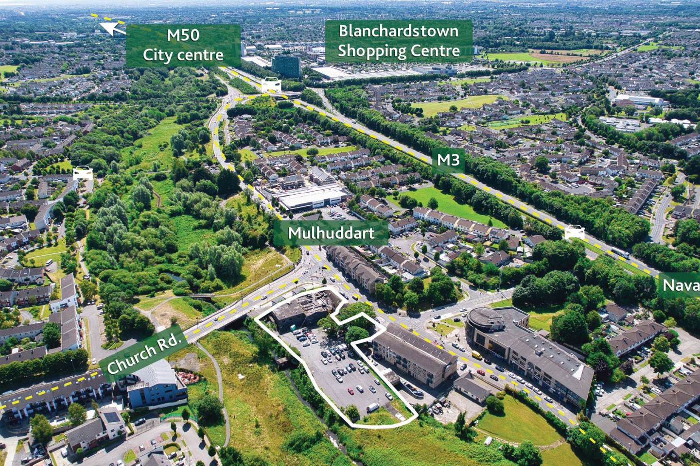
Description: • Residential Development Opportunity (with F.P.P. extended to 10th April 2029) • Site extending to approx. 1.23 acres (0.49 ha) with planning permission for 40 apartments & 3 commercial units • Former Paidi Ogs Public House and car park with potential to increase unit numbers • Ideally located in the centre of Mulhuddart, an area with proven residential demand • Mulhuddart is well serviced by public transport, with a number of bus routes serving the immediate area •Prime west Dublin suburban location, within close proximity to the M3 & M50 and Blanchardstown Shopping Centre Type of Transaction: Private Treaty Price on Application Location Mulhuddart, Co. Dublin is a strategically located commercial hub in West Dublin, just 12 km from the city centre and easily accessible via the N3 and M50 motorway network. This prime location places it within minutes of key transport and business infrastructure, including Dublin Airport, the Port Tunnel, and Dublin`s major logistics and industrial zones, making it highly attractive for businesses seeking excellent connectivity and accessibility. Positioned adjacent to the bustling Blanchardstown Centre, one of Ireland`s largest retail and commercial complexes, Mulhuddart benefits from strong footfall, a large residential population, and proximity to a wide range of services and amenities. The area is home to a mix of established and emerging businesses across retail, logistics, light industrial, and professional services sectors. Public transport is well catered for with numerous Dublin Bus routes and easy access to nearby train stations, supporting employee and customer access. Mulhuddart is also within reach of major business parks such as Blanchardstown Corporate Park and Damastown Industrial Estate, where global companies like IBM and eBay have a presence. This location offers an ideal base for commercial operations seeking a balance of affordability, accessibility, and growth potential within the expanding Greater Dublin Area. The site is located approximately 700 metres from the M3 (exit 3) which provides easy access to the M50 and all the main arterial routes to and from the city. Description The subject property comprises a site extending to approx. 0.49 ha (1.23 acres) and is the Former Paidi Ogs Public House with vehicular and pedestrian access to a surface car park to the rear. The site benefits from excellent frontage onto the Main Street. The public house is currently vacant and the property has the benefit of full planning for 40 apartments & 3 commercial units. The development would consist of 4 no. studios, 14 no. 1 bedroom, 17 no. 2 bedroom and 5 no. three bedroom apartments all with private balconies/terrace areas and three commercial units at ground floor level fronting onto the town centre. There will be 84 surface car parking spaces, 12 of which are designated for commercial use. Zoning The subject lands have two zoning objectives, details as follows; `LC` - Local Centre & `HA` High Amenity under the Fingal Development Plan 2023 - 2029. The LC objective is to Protect, provide for and/or improve local centre facilities`. . Provide a mix of local community and commercial facilities for the existing and developing communities of the County. The aim is to ensure local centres contain a range of community, recreational and retail facilities, including medical/ dental surgeries and childcare facilities, at a scale to cater for both existing residential development and zoned undeveloped lands, as appropriate, at locations which minimise the need for use of the private car and encourage pedestrians, cyclists and the use of public transport. The development will strengthen local retail provision in accordance with the County Retail Strategy. The HA objective is to Protect and enhance high amenity areas`. Protect these highly sensitive and scenic locations from inappropriate development and reinforce their character, distinctiveness and sense of place. In recognition of the amenity potential of these areas opportunities to increase public access will be explored. Planning permission details The site has the benefit of full planning permission for 40 apartments and 3 commercial units under planning reference ABP 308361-20. The planning permission has been extended to 10th April 2029. The development consists of the demolition of the existing two-storey public house premises, and construction of a new building comprising of three commercial units (two retail units, one licenced public house) and 40 apartments, (4 studios, 14 one bedroom apartments, 17 two bedroom apartments and 5 three bedroom apartments). The proposed scheme ranges from lower ground floor to fourth floor with 84 surface car parking spaces, 26 bicycle spaces and all associated landscaping and site works. A full planning pack is available upon request. Services Interested parties are required to satisfy themselves in relation to the availability and adequacy of services. Solicitor Keith Doyle, BHSM LLP, 76 Baggot Street Lower, Dublin 2. Phone: 01 4408300 Email: kdoyle Viewings Viewings available by appointment only. Directions Eircode: D15 EYK2 Contact Information Will Coonan E: willc T: 01 628 6128 what3words /// melons.calculating.backdrops Notice Please note we have not tested any apparatus, fixtures, fittings, or services. Interested parties must undertake their own investigation into the working order of these items. All measurements are approximate and photographs provided for guidance only.
The local area of Former Paidi Ogs Public House
Local schools and transport

Learn more about what this area has to offer.
School Name | Distance | Pupils | |||
|---|---|---|---|---|---|
| School Name | Ladyswell National School | Distance | 490m | Pupils | 434 |
| School Name | Scoil Mhuire Senior School | Distance | 580m | Pupils | 233 |
| School Name | Blakestown Junior School | Distance | 640m | Pupils | 183 |
School Name | Distance | Pupils | |||
|---|---|---|---|---|---|
| School Name | Sacred Heart Of Jesus National School Huntstown | Distance | 840m | Pupils | 661 |
| School Name | Saint Lukes National School | Distance | 1.4km | Pupils | 517 |
| School Name | Powerstown Educate Together National School | Distance | 1.4km | Pupils | 331 |
| School Name | Gaelscoil An Chuilinn | Distance | 1.4km | Pupils | 281 |
| School Name | St Patricks Senior School | Distance | 1.4km | Pupils | 205 |
| School Name | St Patrick's Junior School | Distance | 1.5km | Pupils | 174 |
| School Name | St Philip The Apostle Junior National School | Distance | 1.6km | Pupils | 201 |
School Name | Distance | Pupils | |||
|---|---|---|---|---|---|
| School Name | Blakestown Community School | Distance | 860m | Pupils | 521 |
| School Name | Rath Dara Community College | Distance | 1.2km | Pupils | 297 |
| School Name | Le Chéile Secondary School | Distance | 1.2km | Pupils | 959 |
School Name | Distance | Pupils | |||
|---|---|---|---|---|---|
| School Name | Hartstown Community School | Distance | 1.4km | Pupils | 1124 |
| School Name | Scoil Phobail Chuil Mhin | Distance | 1.6km | Pupils | 1013 |
| School Name | Edmund Rice College | Distance | 2.2km | Pupils | 813 |
| School Name | Colaiste Pobail Setanta | Distance | 2.6km | Pupils | 1069 |
| School Name | Eriu Community College | Distance | 3.1km | Pupils | 194 |
| School Name | Luttrellstown Community College | Distance | 3.1km | Pupils | 998 |
| School Name | Hansfield Etss | Distance | 3.3km | Pupils | 847 |
Type | Distance | Stop | Route | Destination | Provider | ||||||
|---|---|---|---|---|---|---|---|---|---|---|---|
| Type | Bus | Distance | 90m | Stop | Church Road | Route | 238 | Destination | Carlton Hotel | Provider | Go-ahead Ireland |
| Type | Bus | Distance | 90m | Stop | Church Road | Route | 220 | Destination | Dcu Helix | Provider | Go-ahead Ireland |
| Type | Bus | Distance | 160m | Stop | Church Road | Route | 220a | Destination | Mulhuddart | Provider | Go-ahead Ireland |
Type | Distance | Stop | Route | Destination | Provider | ||||||
|---|---|---|---|---|---|---|---|---|---|---|---|
| Type | Bus | Distance | 160m | Stop | Church Road | Route | 236a | Destination | Dublin Tech Campus | Provider | Go-ahead Ireland |
| Type | Bus | Distance | 320m | Stop | Saddlers Avenue | Route | 220a | Destination | Mulhuddart | Provider | Go-ahead Ireland |
| Type | Bus | Distance | 320m | Stop | Saddlers Avenue | Route | 236a | Destination | Dublin Tech Campus | Provider | Go-ahead Ireland |
| Type | Bus | Distance | 320m | Stop | Saddlers Avenue | Route | 238 | Destination | Mulhuddart | Provider | Go-ahead Ireland |
| Type | Bus | Distance | 320m | Stop | Saddlers Avenue | Route | 220 | Destination | Mulhuddart | Provider | Go-ahead Ireland |
| Type | Bus | Distance | 350m | Stop | Coolmine Cottages | Route | 236a | Destination | Blanchardstown | Provider | Go-ahead Ireland |
| Type | Bus | Distance | 350m | Stop | Coolmine Cottages | Route | 220 | Destination | Ballymun | Provider | Go-ahead Ireland |
Ad performance
- Date listed09/11/2025
- Views2,581
Daft ID: 524031854