
Newcastle Aerodrome, Leamore, New Castle, Co. Wicklow, A63RX03
Price on Application
- Available From:Immediately
About Newcastle Aerodrome, Leamore, New Castle, Co. Wicklow
Description
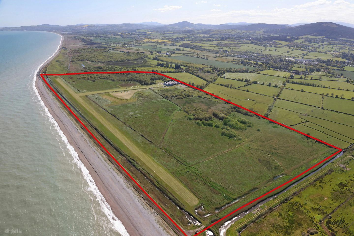
Newcastle Aerodrome is located in Newcastle, Co. Wicklow, approximately 45km south of Dublin City Centre. Newcastle is a small town on Ireland’s east coast with a population of 1,010 as of census 2022. Wider road connectivity to Dublin City and the main regional centres of Cork, Limerick, Galway, Waterford and Belfast are via the M11 / M50 motorway which provides access to the National Road Network. The property is located below Dublin Airport Authorities Class G controlled airspace providing uncontrolled, unrestricted airspace extending from ground up to 7,500 feet AMSL and requiring no clearance for visual flight rule (VFR) flight.The lands are currently in use as a licensed airfield and generally have a level topography throughout. There is a 690-metre grass runway centred on a north – south axis which is operational year-round. Envarq (formerly Engenuiti Consulting Engineers) have prepared a master plan for future development potential on the lands which include a best in class vertiport and drone centre of excellence which could provide training and commercial unmanned aerial vehicle testing, a substantial growth area. At approximately, 200 square miles, the proposed drone training centre would be one of the largest in Europe. Newcastle Aerodrome is in Newcastle, Co. Wicklow, approximately 45km south of Dublin City Centre. Newcastle is a small town on Ireland’s east coast with a population of 1,010 as of census 2022. The property is approximately 500 meters east of Newcastle Town Centre. Vehicular access is provided from the Sea Road via the Newcastle Road. Wider road connectivity to Dublin City and the main regional centres of Cork, Limerick, Galway, Waterford and Belfast are via the M11 / M50 motorway which provides access to the National Road Network. The general area is serviced by Kilcoole Train Station which is located approximately 3km north of the subject property. Commuter trains serve the station with travel times to Dublin City / Grand Canal Dock of 50 minutes. Dublin Airport, the country’s primary international airport with a pax of 36.4 million in 2025 (37.5 million projected for 2026), is situated 63km north of the subject property. Dublin Port, serving as both a transport hub for ferry passenger traffic and commercial freight passing to and from Dublin City is 40km to the north of Newcastle Airfield. The property is located below Dublin Airport Authorities Class G controlled airspace providing uncontrolled, unrestricted airspace extending from ground up to 7,500 feet AMSL and requiring no clearance for visual flight rule (VFR) flight. Key Points: - Substantial landbank extending to 141 acres (57 ha) - Currently comprises 690 meter year round grass runway, hangars and operational infrastructure - Exceptional location adjoining the eastern Irish coastline and the Wicklow Mountains - Situated 500 meters east of Newcastle, Co. Wicklow, 45km south of Dublin City Centre - Located within Class G Airspace – unrestricted flight operations - Customs-approved entry / exit point for aircraft travelling with the UK - Lands benefits from own Air Traffic Zone (ATZ) – no restriction on movement - Masterplan indicates potential for Vertiport and Drone Centre – scope to be among the largest in Europe
The local area of Newcastle Aerodrome, Leamore, New Castle, Co. Wicklow
Local schools and transport

Learn more about what this area has to offer.
School Name | Distance | Pupils | |||
|---|---|---|---|---|---|
| School Name | St Catherine's Special School | Distance | 1.4km | Pupils | 89 |
| School Name | St Francis National School | Distance | 2.1km | Pupils | 95 |
| School Name | Kilcoole Primary School | Distance | 4.5km | Pupils | 575 |
School Name | Distance | Pupils | |||
|---|---|---|---|---|---|
| School Name | Woodstock Educate Together National School | Distance | 5.1km | Pupils | 117 |
| School Name | Newtownmountkennedy Primary School | Distance | 5.2km | Pupils | 365 |
| School Name | Greystones Community National School | Distance | 7.0km | Pupils | 411 |
| School Name | Delgany National School | Distance | 7.3km | Pupils | 207 |
| School Name | Scoil Na Coróine Mhuire | Distance | 7.6km | Pupils | 317 |
| School Name | St Laurence's National School | Distance | 8.1km | Pupils | 673 |
| School Name | Nuns Cross National School | Distance | 8.2km | Pupils | 197 |
School Name | Distance | Pupils | |||
|---|---|---|---|---|---|
| School Name | Colaiste Chraobh Abhann | Distance | 3.4km | Pupils | 774 |
| School Name | Greystones Community College | Distance | 6.9km | Pupils | 630 |
| School Name | St David's Holy Faith Secondary | Distance | 8.3km | Pupils | 772 |
School Name | Distance | Pupils | |||
|---|---|---|---|---|---|
| School Name | Temple Carrig Secondary School | Distance | 9.3km | Pupils | 946 |
| School Name | East Glendalough School | Distance | 9.5km | Pupils | 366 |
| School Name | Coláiste Chill Mhantáin | Distance | 9.8km | Pupils | 933 |
| School Name | Wicklow Educate Together Secondary School | Distance | 10.6km | Pupils | 375 |
| School Name | Dominican College | Distance | 10.6km | Pupils | 473 |
| School Name | St. Kilian's Community School | Distance | 13.7km | Pupils | 416 |
| School Name | Pres Bray | Distance | 13.8km | Pupils | 649 |
Type | Distance | Stop | Route | Destination | Provider | ||||||
|---|---|---|---|---|---|---|---|---|---|---|---|
| Type | Bus | Distance | 1.3km | Stop | Sea Road | Route | X2 | Destination | Hawkins Street | Provider | Dublin Bus |
| Type | Bus | Distance | 1.4km | Stop | Newcastle | Route | L2 | Destination | Bray Station | Provider | Go-ahead Ireland |
| Type | Bus | Distance | 1.6km | Stop | Newcastle Middle | Route | L2 | Destination | Newcastle | Provider | Go-ahead Ireland |
Type | Distance | Stop | Route | Destination | Provider | ||||||
|---|---|---|---|---|---|---|---|---|---|---|---|
| Type | Bus | Distance | 1.7km | Stop | Newcastle Lower | Route | L2 | Destination | Newcastle | Provider | Go-ahead Ireland |
| Type | Bus | Distance | 1.7km | Stop | Gorse Hill | Route | L2 | Destination | Bray Station | Provider | Go-ahead Ireland |
| Type | Bus | Distance | 2.0km | Stop | Leabeg Lane | Route | L2 | Destination | Newcastle | Provider | Go-ahead Ireland |
| Type | Bus | Distance | 2.4km | Stop | Chippin View Cottage | Route | L2 | Destination | Bray Station | Provider | Go-ahead Ireland |
| Type | Bus | Distance | 2.8km | Stop | Woodstock Park | Route | L2 | Destination | Newcastle | Provider | Go-ahead Ireland |
| Type | Bus | Distance | 3.3km | Stop | Kilcoole Golf Club | Route | L2 | Destination | Bray Station | Provider | Go-ahead Ireland |
| Type | Bus | Distance | 3.3km | Stop | Kilcoole Golf Club | Route | X2 | Destination | Newcastle | Provider | Dublin Bus |
BER Details
Ad performance
- Date listed04/06/2026
- Views1,526
Daft ID: 56588569