
Newcastle Site With F.P.P For 13 Apartments, Newcastle, Co. Dublin
Price on Application
- Available From:Immediately
About Newcastle Site With F.P.P For 13 Apartments
Description
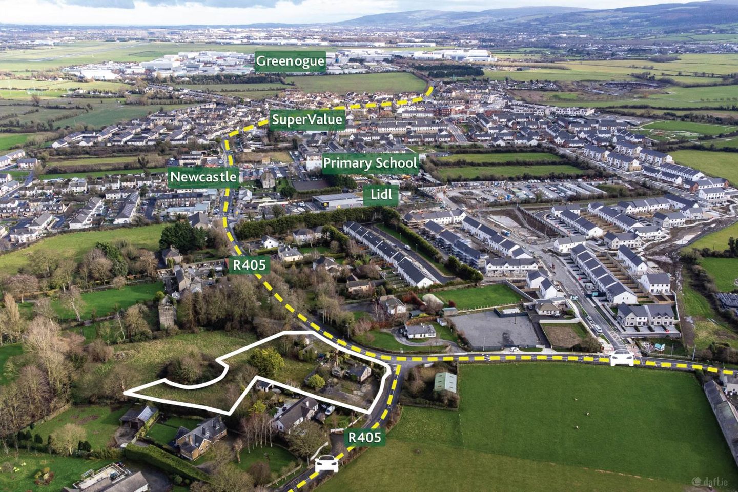
Newcastle, Co. Dublin approx. 1 acre (0.405 ha) with full planning permission for 13 residential apartments Key Points: • Landmark site extending to approx. 1 acre (0.405 ha) with planning permission for 13 residential apartment units • An opportunity for the development of 13 no. spacious apartments on a picturesque site beside the historic grounds of St. Finians Church • Ideally located close to the centre of Newcastle, an area which has undergone much redevelopment in recent years with proven residential demand • Strategically positioned at the junction of the R405 and Main Street Upper, offering high visibility and excellent connectivity • Situated within easy reach of the M4 and M7 motorways and with strong transport links to Dublin city and beyond Description: The subject site extends to approx. 1 acre (0.405 ha) and is located on the junction of the Hazelhatch Road (R405) and Main Street Newcastle (R120). The site currently accommodates a derelict building, formerly McEvoys public house and associated outbuildings. The subject site is bound by residential properties to the north and east and has extensive road frontage onto the Hazelhatch Road, R405, and Main Street, Newcastle. The subject site is zoned Existing Residential (RES) under the South Dublin County Council Development Plan 2022 - 2028 which is " To protect and/or improve residential amenity". The proposed development consists of 13 apartments from South Dublin County Council, Register Reference SD23A/0150. Price On Application Type of Transaction Private Treaty Location The subject site is located in Newcastle, County Dublin, at the key crossroads of the R405 and Main Street Upper, placing it at the heart of this vibrant and rapidly evolving commuter town. Newcastle enjoys a growing residential profile, benefitting from strong demand driven by its accessibility and proximity to surrounding employment centres. The village provides a range of local amenities including shops, schools, cafés, pubs and services, with convenient connections to major road networks. Situated within easy reach of the M4 and M7 motorways and with strong transport links to Dublin city and the wider region. The site is just 4.5km from Hazelhatch Train Station, a short walk to bus stops and the Luas Citywest is also nearby. Many large employers have established their base in nearby in Greenogue Business Park, a major industrial hub, located just 1.5km away. Greenogue hosts approx. 450 companies and roughly 7,000 employees. Key employers include major logistics, manufacturing, and distribution firms such as Amazon, Liebherr, Lucey Transport, Zeus Packaging, Fannin Healthcare, and Univar. Services Interested parties are required to satisfy themselves in relation to the availability and adequacy of services. Zoning Most of the site is zoned Existing Residential` (RES) under the South Dublin County Council Development Plan 2022 - 2028 which is ` to protect and/or improve residential amenity`. Part of the site is zoned RU which is `To protect and improve rural amenity and to provide for the development of agriculture`. Planning Planning permission was granted by South Dublin County Council in May 2024 for the development of 13 residential apartments. A full planning pack is available upon request. Solicitor James V. Tighe & Co. Solicitors, Main St. Celbridge, Co. Kildare. Viewing Viewings available by appointment only. Directions Located at the junction of the Hazelhatch Road ( R405) and Main Street Newcastle (R120). Contact Information Mick Wright E: mickw T: 01 628 8400 Will Coonan E: willc T: 01 628 6128 what3words /// ambush.fasts.extremely Notice Please note we have not tested any apparatus, fixtures, fittings, or services. Interested parties must undertake their own investigation into the working order of these items. All measurements are approximate and photographs provided for guidance only.
The local area of Newcastle Site With F.P.P For 13 Apartments
Local schools and transport

Learn more about what this area has to offer.
School Name | Distance | Pupils | |||
|---|---|---|---|---|---|
| School Name | St Finian's Primary School | Distance | 340m | Pupils | 644 |
| School Name | Holy Family National School | Distance | 3.0km | Pupils | 699 |
| School Name | Scoil Chronain | Distance | 3.3km | Pupils | 381 |
School Name | Distance | Pupils | |||
|---|---|---|---|---|---|
| School Name | St. Patrick's Primary School | Distance | 3.9km | Pupils | 384 |
| School Name | St Annes National School | Distance | 4.0km | Pupils | 344 |
| School Name | Primrose Hill National School | Distance | 4.6km | Pupils | 113 |
| School Name | St Mary's Saggart | Distance | 4.8km | Pupils | 673 |
| School Name | City West Educate Together National School | Distance | 4.9km | Pupils | 378 |
| School Name | Citywest & Saggart Community National School | Distance | 4.9km | Pupils | 419 |
| School Name | Gaelscoil Lir | Distance | 4.9km | Pupils | 48 |
School Name | Distance | Pupils | |||
|---|---|---|---|---|---|
| School Name | Holy Family Community School | Distance | 3.1km | Pupils | 986 |
| School Name | Adamstown Community College | Distance | 5.1km | Pupils | 980 |
| School Name | Coláiste Pobail Fóla | Distance | 5.1km | Pupils | 658 |
School Name | Distance | Pupils | |||
|---|---|---|---|---|---|
| School Name | St Wolstans Community School | Distance | 5.3km | Pupils | 820 |
| School Name | Dublin College Clondalkin - Deansrath | Distance | 6.4km | Pupils | 425 |
| School Name | St Aidan's Community School | Distance | 6.5km | Pupils | 560 |
| School Name | Lucan Community College | Distance | 6.6km | Pupils | 966 |
| School Name | Griffeen Community College | Distance | 6.7km | Pupils | 537 |
| School Name | Kishoge Community College | Distance | 6.7km | Pupils | 925 |
| School Name | Mount Seskin Community College | Distance | 6.8km | Pupils | 327 |
Type | Distance | Stop | Route | Destination | Provider | ||||||
|---|---|---|---|---|---|---|---|---|---|---|---|
| Type | Bus | Distance | 430m | Stop | Peamount Road | Route | 69n | Destination | Saggart | Provider | Nitelink, Dublin Bus |
| Type | Bus | Distance | 430m | Stop | Peamount Road | Route | W6 | Destination | The Square | Provider | Go-ahead Ireland |
| Type | Bus | Distance | 440m | Stop | Peamount Road | Route | 68 | Destination | Poolbeg St | Provider | Dublin Bus |
Type | Distance | Stop | Route | Destination | Provider | ||||||
|---|---|---|---|---|---|---|---|---|---|---|---|
| Type | Bus | Distance | 450m | Stop | Newcastle | Route | 68 | Destination | Poolbeg St | Provider | Dublin Bus |
| Type | Bus | Distance | 510m | Stop | Main Street | Route | W6 | Destination | Community College | Provider | Go-ahead Ireland |
| Type | Bus | Distance | 530m | Stop | Newcastle | Route | W6 | Destination | The Square | Provider | Go-ahead Ireland |
| Type | Bus | Distance | 530m | Stop | Newcastle | Route | 69n | Destination | Saggart | Provider | Nitelink, Dublin Bus |
| Type | Bus | Distance | 680m | Stop | Cornerpark | Route | W6 | Destination | Community College | Provider | Go-ahead Ireland |
| Type | Bus | Distance | 680m | Stop | Graydon Road | Route | W6 | Destination | Community College | Provider | Go-ahead Ireland |
| Type | Bus | Distance | 710m | Stop | Graydon Road | Route | 69n | Destination | Saggart | Provider | Nitelink, Dublin Bus |
Ad performance
- Date listed04/03/2026
- Views1,157
Daft ID: 56512215
