
Robinstown, Mullingar, Co. Westmeath
Price on Application
- Selling Type:By Private Treaty
- Available From:Immediately
About Robinstown, Mullingar, Co. Westmeath
Description
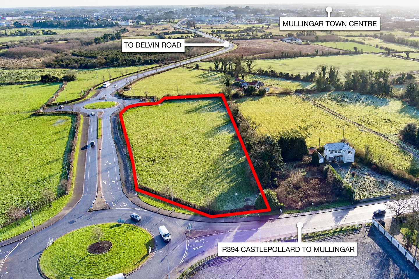
C. 2.5 acres of development land located in Mullingar town centre. This is without doubt one of the finest sites to come to the market in recent years, it has endless possibilities to develop and to add to the all-ready vibrant town that Mullingar is. Set among stunning lakes and inland waterways, Mullingar and surrounding areas can offer peaceful living combined with a bustling commercial and retail life. Mullingar has an excellent transport links to the capital by road and rail. Its close proximity to Dublin and excellent road network links to every part of Ireland making Mullingar a quality place for Industry. Living in Mullingar means you belong to a community, a diverse location with a thriving social scene and outdoor recreation for all the family. In the Heart of Ireland€TM Ancient East, Mullingar boards a landscape rich in musical heritage, history, myth and legends with a wide and varied range of attractions available in and around the town. For more about visiting Mullingar visit Mullingar.ie. Mullingar and the Midlands region have been continuously endorsed by global brands in Life Sciences, Software Development and Manufacturing industries. These knowledge-intensive companies are drawn to the Midlands area due to the skilled, multilingual workforce and local expertise in Business, Science, Manufacturing, Engineering and Management. The Mullingar area boast leading international brands across a range of sectors including Life Science, AutomotiveAerospace, Manufacturing, Food, Financial, Insurance, Professional Services and Pharma. Mullingar is linked with the adjoining towns of Athlone and Tullamore to form one of the most important gateway networks in the country. The Midlands Gateway network, comprising of a combined population of 130,000, will receive increased funding from national resources to further develop infrastructure, enterprise and industrial activity in this region. The draft Mullingar Local Area Plan 2025 is currently being complied with further submissions being accepted later this year. Viewing Details: Contact Mullingar 044 9342512 or Enfield 046 954332 C. 2.5 ACRES €" Office/Business/Technology Innovation & Technology Zoning: To provide for high value high Tech knowledge, R&D and SMART industries in a high quality built and landscaped environment. This zoning is aimed at providing a location for high end, high quality, value added businesses and corporate headquarters. The focus in this area shall be on creating knowledge-based enterprise clusters. An emphasis on exemplar sustainable design and aesthetic quality will be promoted to enhance corporate image and identity
The local area of Robinstown, Mullingar, Co. Westmeath
Local schools and transport

Learn more about what this area has to offer.
School Name | Distance | Pupils | |||
|---|---|---|---|---|---|
| School Name | St Brigid's Special School | Distance | 1.4km | Pupils | 86 |
| School Name | Presentation Senior School | Distance | 1.4km | Pupils | 307 |
| School Name | Presentation Junior School | Distance | 1.4km | Pupils | 284 |
School Name | Distance | Pupils | |||
|---|---|---|---|---|---|
| School Name | Bellview National School | Distance | 1.6km | Pupils | 464 |
| School Name | St. Marys Primary School | Distance | 1.7km | Pupils | 426 |
| School Name | Gaelscoil An Mhuilinn | Distance | 1.8km | Pupils | 183 |
| School Name | All Saints National School Mullingar | Distance | 1.8km | Pupils | 87 |
| School Name | Gaelscoil An Choillín | Distance | 1.9km | Pupils | 145 |
| School Name | Mullingar Educate Together National School | Distance | 2.3km | Pupils | 379 |
| School Name | Saplings Special School | Distance | 2.8km | Pupils | 36 |
School Name | Distance | Pupils | |||
|---|---|---|---|---|---|
| School Name | St. Finian's College | Distance | 1.0km | Pupils | 877 |
| School Name | Loreto College | Distance | 1.3km | Pupils | 839 |
| School Name | Colaiste Mhuire, | Distance | 1.6km | Pupils | 835 |
School Name | Distance | Pupils | |||
|---|---|---|---|---|---|
| School Name | Mullingar Community College | Distance | 1.9km | Pupils | 375 |
| School Name | Wilson's Hospital School | Distance | 9.4km | Pupils | 430 |
| School Name | Columba College | Distance | 13.5km | Pupils | 297 |
| School Name | St Joseph's Secondary School | Distance | 14.3km | Pupils | 1125 |
| School Name | Castlepollard Community College | Distance | 15.0km | Pupils | 334 |
| School Name | Mercy Secondary School | Distance | 21.8km | Pupils | 720 |
| School Name | Mercy Secondary School | Distance | 28.2km | Pupils | 760 |
Type | Distance | Stop | Route | Destination | Provider | ||||||
|---|---|---|---|---|---|---|---|---|---|---|---|
| Type | Bus | Distance | 340m | Stop | Sherwood Park | Route | Mu1 | Destination | Lough Sheever Corporate Park | Provider | Bernard Kavanagh & Sons |
| Type | Bus | Distance | 360m | Stop | Sherwood Park | Route | 818 | Destination | Mullingar | Provider | Tfi Local Link Longford Westmeath Roscommon |
| Type | Bus | Distance | 480m | Stop | Lough Sheever Corporate Park | Route | Mu1 | Destination | Lough Sheever Corporate Park | Provider | Bernard Kavanagh & Sons |
Type | Distance | Stop | Route | Destination | Provider | ||||||
|---|---|---|---|---|---|---|---|---|---|---|---|
| Type | Bus | Distance | 890m | Stop | Saint Mary's Hospital | Route | 70 | Destination | Mullingar | Provider | Bus Éireann |
| Type | Bus | Distance | 890m | Stop | Saint Mary's Hospital | Route | Mu1 | Destination | Lough Sheever Corporate Park | Provider | Bernard Kavanagh & Sons |
| Type | Bus | Distance | 890m | Stop | Saint Mary's Hospital | Route | 818 | Destination | Castlepollard | Provider | Tfi Local Link Longford Westmeath Roscommon |
| Type | Bus | Distance | 890m | Stop | Saint Mary's Hospital | Route | 23 | Destination | Sligo | Provider | Bus Éireann |
| Type | Bus | Distance | 900m | Stop | Ballyglass | Route | 816 | Destination | Mullingar | Provider | Tfi Local Link Longford Westmeath Roscommon |
| Type | Bus | Distance | 1.1km | Stop | Regional Hospital | Route | 819 | Destination | Athlone | Provider | Tfi Local Link Longford Westmeath Roscommon |
| Type | Bus | Distance | 1.1km | Stop | Regional Hospital | Route | Mu2 | Destination | Ardmore Road | Provider | Bernard Kavanagh & Sons |
BER Details
Ad performance
- Date listed15/02/2024
- Views3,960
Daft ID: 519011027