
Approx. 10.9 Acres, Tay Lane, Rathcreedan, Rathcoole, Co. Dublin
€6,550,000
- Available From:Immediately
About this property
Description
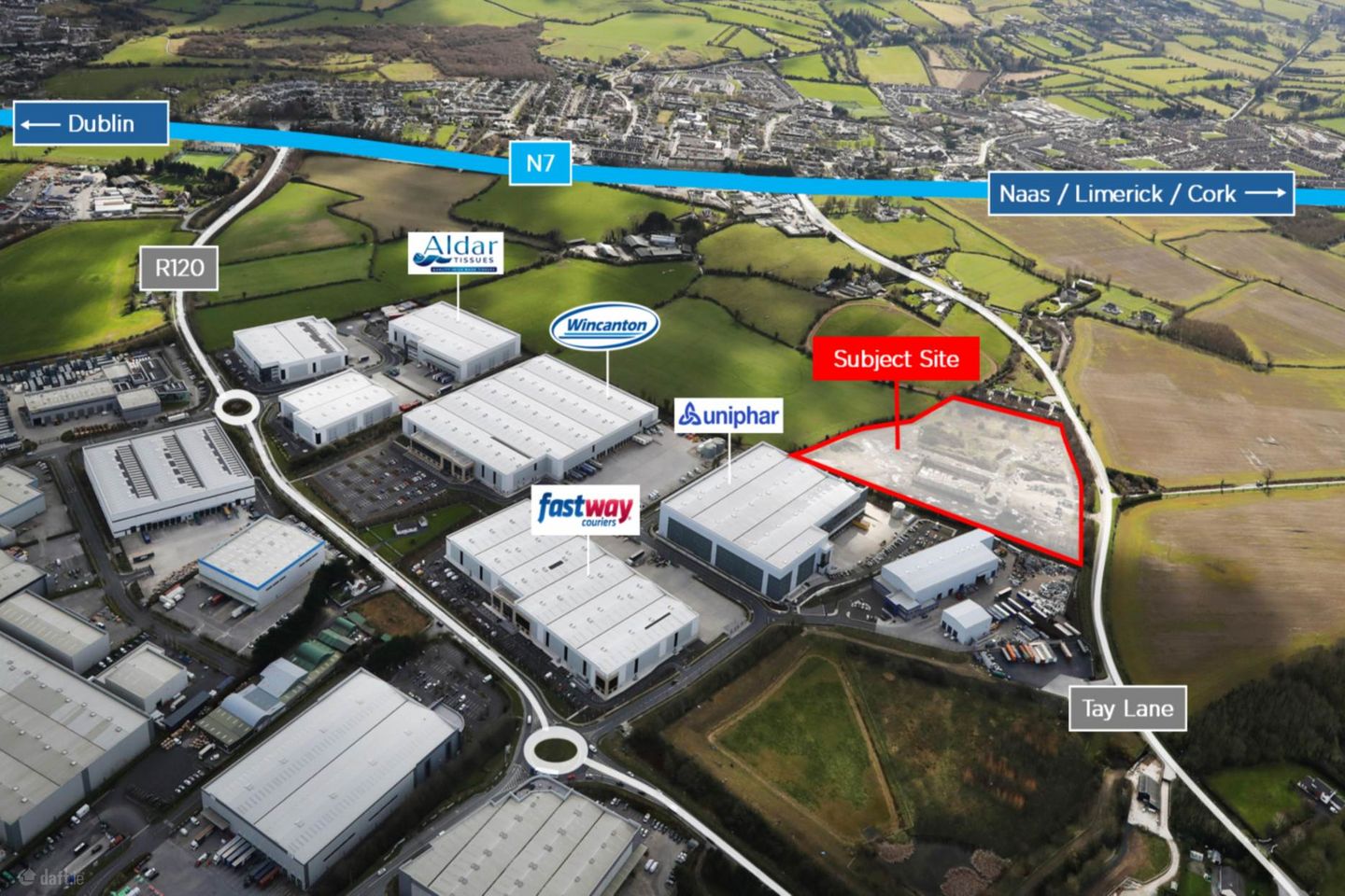
Excellent developer / owner occupier opportunity with the benefit of full planning permission for 6 industrial units extending to approx. 170,776 sq.ft. Description • Rare opportunity to acquire a prime industrial site with excellent connectivity. • Regular shaped site extending to approx.10.92 acres. • Zoned for Enterprise & Employment, facilitating a wide range of user types. • Benefits from full planning permission. Location The subject site is well located off Tay Lane. The site is situated approx. 2.3km north of the N7 / Rathcoole Junction, providing access to the M50 (approx. 9km). The site`s proximity to the N7 allows for access to both Dublin Port (approx. 34km) and Dublin Airport (approx. 28km). Planning Permission The site represents a unique opportunity to acquire a significant portion of land which already benefits from full planning permission (Ref: SD23A/0286) for 6 industrial units extending to approx. 170,776 sq.ft. All relevant planning information and engineering detail can be obtained from our data room which is available on request. Under the South Dublin County Council Development Plan 2022 2028, the site is zoned: Enterprise & Employment,` To provide for enterprise and employment related uses. Inspections All inspections are strictly by appointment through joint agents, Coonan Property and Savills. Price Excess €6,550,000 (exclusive) Contacts For further information or to arrange a viewing please contact: Will Coonan Director T: +353 1 610 6053 willc Jarlath Lynn Director T: +353 1 6181355 jarlath.lynn Notice Please note we have not tested any apparatus, fixtures, fittings, or services. Interested parties must undertake their own investigation into the working order of these items. All measurements are approximate and photographs provided for guidance only.
The local area
The local area
Local schools and transport

Learn more about what this area has to offer.
School Name | Distance | Pupils | |||
|---|---|---|---|---|---|
| School Name | Holy Family National School | Distance | 920m | Pupils | 699 |
| School Name | Scoil Chronain | Distance | 1.0km | Pupils | 381 |
| School Name | St Finian's Primary School | Distance | 2.0km | Pupils | 644 |
School Name | Distance | Pupils | |||
|---|---|---|---|---|---|
| School Name | St Mary's Saggart | Distance | 2.5km | Pupils | 673 |
| School Name | City West Educate Together National School | Distance | 2.7km | Pupils | 378 |
| School Name | Citywest & Saggart Community National School | Distance | 2.7km | Pupils | 419 |
| School Name | Gaelscoil Lir | Distance | 2.7km | Pupils | 48 |
| School Name | Rathcoole Etns | Distance | 2.7km | Pupils | 119 |
| School Name | St Aidan's National School | Distance | 4.9km | Pupils | 244 |
| School Name | St Brigids Brookfield | Distance | 4.9km | Pupils | 212 |
School Name | Distance | Pupils | |||
|---|---|---|---|---|---|
| School Name | Holy Family Community School | Distance | 1.3km | Pupils | 986 |
| School Name | Coláiste Pobail Fóla | Distance | 3.0km | Pupils | 658 |
| School Name | St Aidan's Community School | Distance | 4.4km | Pupils | 560 |
School Name | Distance | Pupils | |||
|---|---|---|---|---|---|
| School Name | Mount Seskin Community College | Distance | 4.7km | Pupils | 327 |
| School Name | Adamstown Community College | Distance | 5.4km | Pupils | 980 |
| School Name | Deansrath Community College | Distance | 5.5km | Pupils | 425 |
| School Name | Killinarden Community School | Distance | 5.5km | Pupils | 508 |
| School Name | St Marks Community School | Distance | 6.0km | Pupils | 924 |
| School Name | Griffeen Community College | Distance | 6.3km | Pupils | 537 |
| School Name | Kishoge Community College | Distance | 6.3km | Pupils | 925 |
Type | Distance | Stop | Route | Destination | Provider | ||||||
|---|---|---|---|---|---|---|---|---|---|---|---|
| Type | Bus | Distance | 600m | Stop | Tay Lane | Route | 69n | Destination | Saggart | Provider | Nitelink, Dublin Bus |
| Type | Bus | Distance | 600m | Stop | Tay Lane | Route | 68 | Destination | Greenogue | Provider | Dublin Bus |
| Type | Bus | Distance | 600m | Stop | Greenogue Rdbt | Route | W6 | Destination | The Square | Provider | Go-ahead Ireland |
Type | Distance | Stop | Route | Destination | Provider | ||||||
|---|---|---|---|---|---|---|---|---|---|---|---|
| Type | Bus | Distance | 680m | Stop | Tay Lane | Route | W6 | Destination | Community College | Provider | Go-ahead Ireland |
| Type | Bus | Distance | 720m | Stop | Greenogue Ie | Route | W6 | Destination | Community College | Provider | Go-ahead Ireland |
| Type | Bus | Distance | 780m | Stop | Holy Family Ns | Route | 126d | Destination | Kildare | Provider | Go-ahead Ireland |
| Type | Bus | Distance | 780m | Stop | Holy Family Ns | Route | 126n | Destination | Newbridge | Provider | Go-ahead Ireland |
| Type | Bus | Distance | 780m | Stop | Holy Family Ns | Route | 126a | Destination | Rathangan | Provider | Go-ahead Ireland |
| Type | Bus | Distance | 780m | Stop | Holy Family Ns | Route | 126t | Destination | Rathangan | Provider | Go-ahead Ireland |
| Type | Bus | Distance | 780m | Stop | Holy Family Ns | Route | 125 | Destination | Toughers Ind Est | Provider | Go-ahead Ireland |
Ad performance
- Date listed20/08/2025
- Views2,624
Daft ID: 522871547