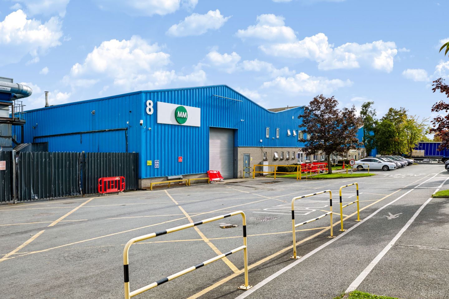

Unit 7-8, Airways Industrial Estate, Swords Road, Santry, Dublin 9
Price on Application
- Available From:Immediately
About Unit 7-8, Airways Industrial Estate, Swords Road, Santry, Dublin 9
Description
Location The property is situated within the established Airways Industrial Estate, a well-established industrial and logistics location in north Dublin. strategically positioned north of Santry Village and home to a number of leading occupiers including UPS, AbbVie and DPD. The property is located approximately 3 km from the M1/M50 interchange, providing direct access to the national motorway network, while Dublin Airport and Dublin Port are situated approximately 2.5 km and 11.5 km away respectively. Property The subject property comprises two separate adjoining warehouse facilities with ancillary offices, extending to approximately 8,328 sq. m (89,649 sq. ft) on a site of approximately 1.46 hectares (3.60 acres). The units are interconnected and provide warehouse accommodation with two-storey offices to the front. The two-storey offices extend across the front of both units to approximately 703 sq. m (7,575 sq. ft), accounting for approximately 8% office content. The warehouse accommodation provides a clear internal height of approximately 6 metres, with loading access by means of four grade level roller shutter doors, two per unit. A secure hard-standing yard serves both buildings, with surface car parking to the front and sides for approximately 100 cars. The site has four vehicular and two pedestrian access points and occupies a strategic North Dublin location, approximately 3 km from the M1/M50 interchange. Unit 7 Airways holds a Building Energy Rating (BER) of C3 and Unit 8 Airways holds a BER of C2. Tenancy Units 7 & 8 Airways Industrial Estate are fully let to MM Fibre Packaging Ireland Limited (formerly Essentra Packaging Ireland Limited) on two separate 15-year leases producing €896,490 p.a., expiring on 30 June 2030 and 31 January 2031 respectively.
The local area of Unit 7-8, Airways Industrial Estate, Swords Road, Santry, Dublin 9
Local schools and transport

Learn more about what this area has to offer.
School Name | Distance | Pupils | |||
|---|---|---|---|---|---|
| School Name | Gaelscoil Cholmcille | Distance | 1.1km | Pupils | 221 |
| School Name | Scoil Fhursa | Distance | 1.5km | Pupils | 185 |
| School Name | Scoil Íde Girls National School | Distance | 1.5km | Pupils | 156 |
School Name | Distance | Pupils | |||
|---|---|---|---|---|---|
| School Name | Gaelscoil Bhaile Munna | Distance | 1.6km | Pupils | 171 |
| School Name | St Paul's Special School | Distance | 1.7km | Pupils | 54 |
| School Name | Beaumont Hospital School | Distance | 1.9km | Pupils | 7 |
| School Name | St Francis Senior National School | Distance | 1.9km | Pupils | 195 |
| School Name | Virgin Mary Boys National School | Distance | 2.0km | Pupils | 161 |
| School Name | Virgin Mary Girls National School | Distance | 2.0km | Pupils | 177 |
| School Name | St Francis Js Priorswood | Distance | 2.0km | Pupils | 171 |
School Name | Distance | Pupils | |||
|---|---|---|---|---|---|
| School Name | Coolock Community College | Distance | 1.7km | Pupils | 192 |
| School Name | Our Lady Of Mercy College | Distance | 2.1km | Pupils | 379 |
| School Name | Trinity Comprehensive School | Distance | 2.2km | Pupils | 574 |
School Name | Distance | Pupils | |||
|---|---|---|---|---|---|
| School Name | Ellenfield Community College | Distance | 2.4km | Pupils | 103 |
| School Name | St. Aidan's C.b.s | Distance | 2.6km | Pupils | 728 |
| School Name | Chanel College | Distance | 2.8km | Pupils | 466 |
| School Name | St. David's College | Distance | 2.9km | Pupils | 505 |
| School Name | Clonturk Community College | Distance | 3.0km | Pupils | 939 |
| School Name | Plunket College Of Further Education | Distance | 3.0km | Pupils | 40 |
| School Name | Mercy College Coolock | Distance | 3.3km | Pupils | 420 |
Type | Distance | Stop | Route | Destination | Provider | ||||||
|---|---|---|---|---|---|---|---|---|---|---|---|
| Type | Bus | Distance | 360m | Stop | Furry Park | Route | 41d | Destination | Abbey St | Provider | Dublin Bus |
| Type | Bus | Distance | 360m | Stop | Furry Park | Route | 41c | Destination | Abbey St | Provider | Dublin Bus |
| Type | Bus | Distance | 360m | Stop | Furry Park | Route | 16d | Destination | Ballinteer | Provider | Dublin Bus |
Type | Distance | Stop | Route | Destination | Provider | ||||||
|---|---|---|---|---|---|---|---|---|---|---|---|
| Type | Bus | Distance | 360m | Stop | Furry Park | Route | 16 | Destination | O'Connell Street | Provider | Dublin Bus |
| Type | Bus | Distance | 360m | Stop | Furry Park | Route | 41 | Destination | Abbey St | Provider | Dublin Bus |
| Type | Bus | Distance | 360m | Stop | Furry Park | Route | 41b | Destination | Abbey St | Provider | Dublin Bus |
| Type | Bus | Distance | 360m | Stop | Furry Park | Route | 33 | Destination | Balbriggan | Provider | Dublin Bus |
| Type | Bus | Distance | 360m | Stop | Furry Park | Route | 33n | Destination | Marsh Lane | Provider | Nitelink, Dublin Bus |
| Type | Bus | Distance | 360m | Stop | Furry Park | Route | 33e | Destination | Skerries | Provider | Dublin Bus |
| Type | Bus | Distance | 360m | Stop | Furry Park | Route | 27b | Destination | Harristown | Provider | Dublin Bus |
BER Details
Ad performance
- Date listed03/11/2026
- Views62
Daft ID: 56712075