
Walsh Animal Feeds, Forrest Great, Cloghran, Co. Dublin, K67EE06
€2,500,000
- Available From:Immediately
About this property
Description
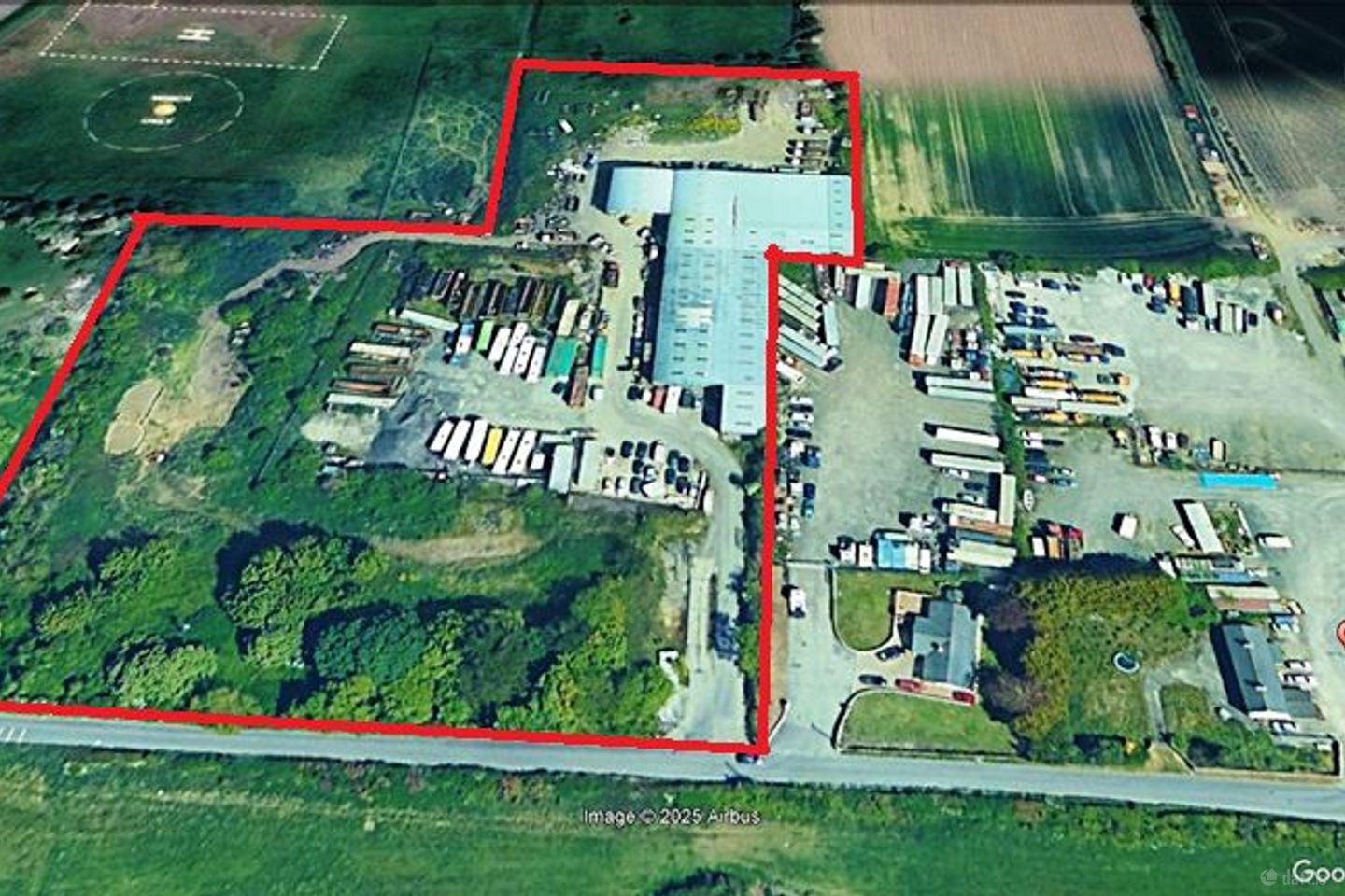
Quantum Property Consultants are pleased to present an Income producing 7.66-acre parcel of land located on Cooks Road, Forrest Great, Swords, North County Dublin to the market. The lands contain some large steel frame constructed agricultural buildings with corrugated exterior steel façade. We are advised the buildings measure circa 30,000 sq. ft. in size. There are also some temporary cabins on site and large open plan areas of space. Location The subject property is located only 3 km from Swords Village and the recently approved ‘Metro Link’ and it’s proposed station at ‘Ridgewood’ is also only 3km away. The site is bound by Cooks Road to the south, Greenfield lands to the West & North and a storage yard facility to the East. The surrounding location is generally characterised of Agricultural land, buildings and one-off housing. Occupiers Currently, there are 20 operators utilizing the site to varying degrees, including car mechanics, bus operators, storage facilities, skip hire, pallet repairs and storage, HGV repairs, coach parking, and plumbing contractors. We are advised there are verbal agreements in place with occupiers which produce an annual income in the region of €156,000 which is set to increase to circa €250,000 from January 1st, 2026. With active asset management such as leasing vacant units and optimizing land use this income could potentially increase to over €300,000 per annum, subject to necessary capital expenditure to develop currently unused areas. ***Details available on request*** ***It is important to note that no formal agreements are in place*** The Subject site is located in an area that is designated objective ‘Greenbelt’ under the Fingal Development Plan 2023 to 2029. Zoning Overview (Green Belt - "GB") Objective: To protect and provide for a Green Belt that delineates urban and rural boundaries, prevents urban sprawl, coalescence of settlements, and encroachment on the countryside. The Green Belt aims to preserve attractive landscapes, promote sustainable links between urban and rural areas, facilitate countryside access, support recreational activities, retain agricultural land, and encourage regeneration of derelict urban areas. Zoning - ‘Permitted in Principle’ Agricultural Buildings, Agri-Tourism, Bed and Breakfast, Boarding Kennels, Burial Grounds, Childcare Facilities, Community Facilities, Farm Shops, Golf Courses, Guest Houses, Health Practitioners, Holiday Homes/Apartments, Office Ancillary to Permitted Uses, Open Spaces, Recreational/Sports Facilities, Research and Development, Residential Accommodation, Restaurants/Cafés, Veterinary Clinics, Campsites. This zoning creates opportunities for diverse uses, particularly those compatible with rural and recreational activities, while maintaining the Green Belt’s overarching objectives of safeguarding the rural landscape.
The local area
The local area
Local schools and transport

Learn more about what this area has to offer.
School Name | Distance | Pupils | |||
|---|---|---|---|---|---|
| School Name | Holy Family Jns | Distance | 1.6km | Pupils | 581 |
| School Name | Holy Family Jns | Distance | 1.6km | Pupils | 581 |
| School Name | Holy Family Senior School | Distance | 1.7km | Pupils | 627 |
School Name | Distance | Pupils | |||
|---|---|---|---|---|---|
| School Name | Holy Family Senior School | Distance | 1.7km | Pupils | 627 |
| School Name | St Cronan's Jns | Distance | 2.5km | Pupils | 499 |
| School Name | St Cronan's Jns | Distance | 2.5km | Pupils | 499 |
| School Name | Mary Queen Of Ireland National School | Distance | 2.5km | Pupils | 105 |
| School Name | Mary Queen Of Ireland National School | Distance | 2.5km | Pupils | 105 |
| School Name | Scoil Chrónáin Sns | Distance | 2.5km | Pupils | 569 |
| School Name | Scoil Chrónáin Sns | Distance | 2.5km | Pupils | 569 |
School Name | Distance | Pupils | |||
|---|---|---|---|---|---|
| School Name | Loreto College Swords | Distance | 1.7km | Pupils | 632 |
| School Name | Loreto College Swords | Distance | 1.7km | Pupils | 632 |
| School Name | Coláiste Choilm | Distance | 2.6km | Pupils | 425 |
School Name | Distance | Pupils | |||
|---|---|---|---|---|---|
| School Name | Coláiste Choilm | Distance | 2.6km | Pupils | 425 |
| School Name | St. Finian's Community College | Distance | 3.5km | Pupils | 661 |
| School Name | St. Finian's Community College | Distance | 3.5km | Pupils | 661 |
| School Name | Swords Community College | Distance | 3.5km | Pupils | 930 |
| School Name | Swords Community College | Distance | 3.5km | Pupils | 930 |
| School Name | Fingal Community College | Distance | 3.5km | Pupils | 866 |
| School Name | Fingal Community College | Distance | 3.5km | Pupils | 866 |
Type | Distance | Stop | Route | Destination | Provider | ||||||
|---|---|---|---|---|---|---|---|---|---|---|---|
| Type | Bus | Distance | 670m | Stop | Forrest Little | Route | 102 | Destination | Dublin Airport | Provider | Go-ahead Ireland |
| Type | Bus | Distance | 680m | Stop | Forrest Little | Route | 102 | Destination | Sutton Station | Provider | Go-ahead Ireland |
| Type | Bus | Distance | 680m | Stop | Forrest Little | Route | 102 | Destination | Sutton Station | Provider | Go-ahead Ireland |
Type | Distance | Stop | Route | Destination | Provider | ||||||
|---|---|---|---|---|---|---|---|---|---|---|---|
| Type | Bus | Distance | 1.3km | Stop | Ridgewood | Route | 102 | Destination | Dublin Airport | Provider | Go-ahead Ireland |
| Type | Bus | Distance | 1.4km | Stop | Ridgewood | Route | 741 | Destination | Dublin Airport Zone 16 | Provider | Ashbourne Connect |
| Type | Bus | Distance | 1.4km | Stop | Ridgewood | Route | 102 | Destination | Sutton Station | Provider | Go-ahead Ireland |
| Type | Bus | Distance | 1.4km | Stop | Forest Crescent | Route | 102 | Destination | Sutton Station | Provider | Go-ahead Ireland |
| Type | Bus | Distance | 1.4km | Stop | Forest Crescent | Route | 33n | Destination | Marsh Lane | Provider | Nitelink, Dublin Bus |
| Type | Bus | Distance | 1.4km | Stop | Forest Crescent | Route | 41b | Destination | Rolestown | Provider | Dublin Bus |
| Type | Bus | Distance | 1.4km | Stop | Forest Crescent | Route | 33n | Destination | Mourne View | Provider | Nitelink, Dublin Bus |
BER Details
Ad performance
- Date listed14/11/2025
- Views2,609
Daft ID: 56346322