
Windgates, Greystones, Co. Wicklow
Price on Application
- Available From:Immediately
About Greystones Windgates
Description
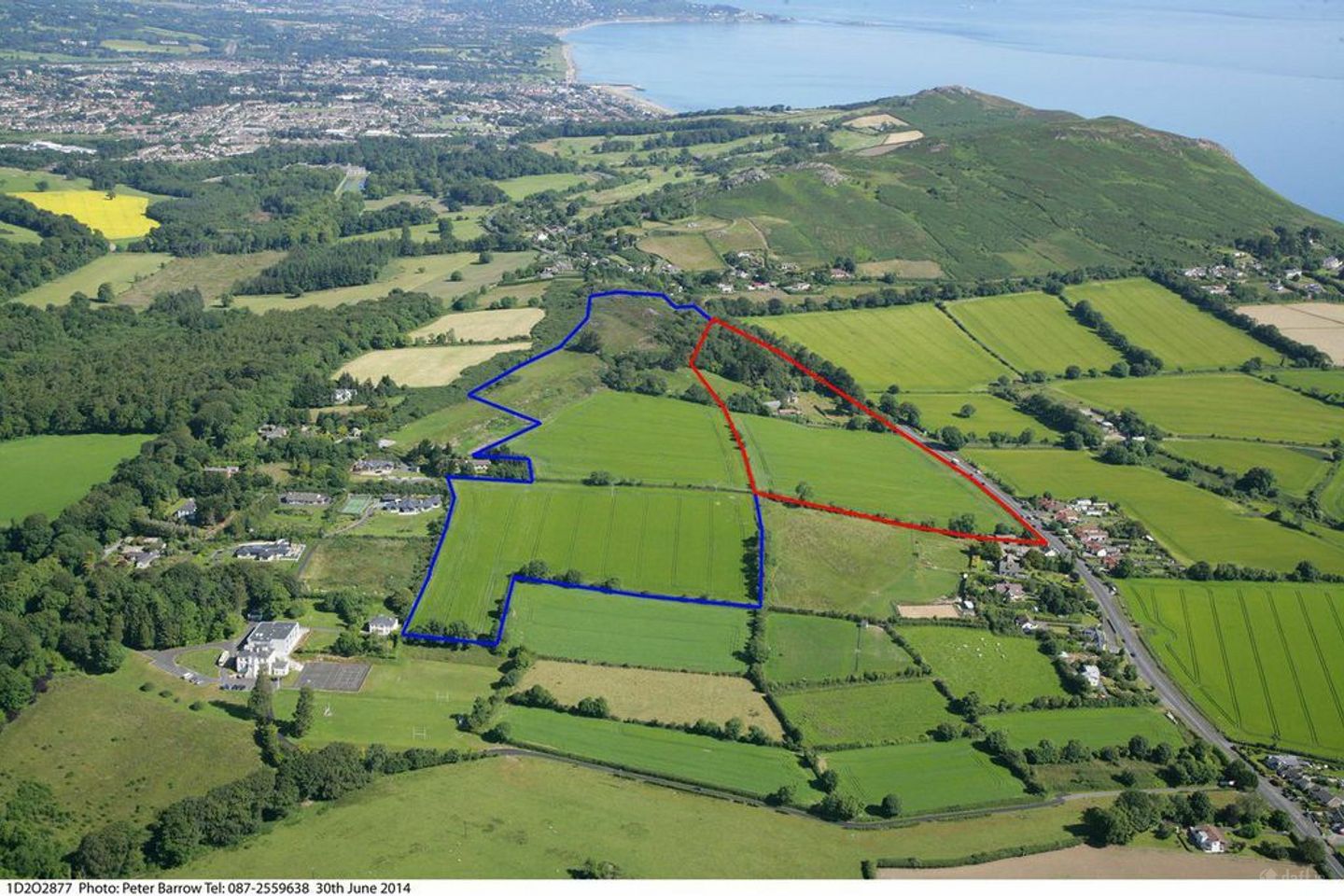
Approximately 20.23 Ha./50 Acres of land zoned "E2 in the Wicklow County Development Plan. Available in two lots. Lot 1: The Entire 20.23 Ha./50 Acres Lot 2: Approximately 20 Acres of Land Zoned "E2 Prime Location midway between Bray and Greystones, part of the Greater Dublin Area. The M11 is easily accesible from the site. In close proximity to tourist attractions including Greystones' Cliff walks, Beach and Harbour with views of the Little Sugar Loaf Mountain and Irish Sea. Greystones and Wicklow Lawn Tennis Clubs, and Glen of the Downs, Delgany, Greystones and Bray Golf Clubs are all in the vicinity of the site. The Greystones site is the highest point between the Little Sugar Loaf Mountain to the west and the Irish Sea to the east. Nature trails and gardens along the existing tracks thru the densely wooded area to the north as this is a high point in the area there is a great opportunity for beautiful views and scenic walks within the site. A Greystones Wellness Campus would be appropriate for the Windgates site. Approximately 20 Acres of the property is situated in an area zoned under objective 'E2' of the Wicklow County Development Plan 2010-2016 - To provide for a single undivided employment unit.
The local area of Greystones Windgates
Local schools and transport

Learn more about what this area has to offer.
School Name | Distance | Pupils | |||
|---|---|---|---|---|---|
| School Name | Gaelscoil Na Gcloch Liath | Distance | 1.9km | Pupils | 256 |
| School Name | Greystones Educate Together National School | Distance | 1.9km | Pupils | 441 |
| School Name | St Kevin's National School | Distance | 2.3km | Pupils | 458 |
School Name | Distance | Pupils | |||
|---|---|---|---|---|---|
| School Name | New Court School | Distance | 2.5km | Pupils | 103 |
| School Name | St Andrews Bray | Distance | 2.5km | Pupils | 209 |
| School Name | St Patrick's National School | Distance | 2.5km | Pupils | 407 |
| School Name | Scoil Chualann | Distance | 2.9km | Pupils | 189 |
| School Name | St Brigid's National School | Distance | 2.9km | Pupils | 389 |
| School Name | St Laurence's National School | Distance | 3.0km | Pupils | 673 |
| School Name | St Fergal's National School | Distance | 3.1km | Pupils | 391 |
School Name | Distance | Pupils | |||
|---|---|---|---|---|---|
| School Name | Temple Carrig Secondary School | Distance | 1.7km | Pupils | 946 |
| School Name | Pres Bray | Distance | 2.8km | Pupils | 649 |
| School Name | St David's Holy Faith Secondary | Distance | 3.0km | Pupils | 772 |
School Name | Distance | Pupils | |||
|---|---|---|---|---|---|
| School Name | St. Kilian's Community School | Distance | 3.1km | Pupils | 416 |
| School Name | Loreto Secondary School | Distance | 3.4km | Pupils | 735 |
| School Name | St Thomas' Community College | Distance | 3.8km | Pupils | 14 |
| School Name | North Wicklow Educate Together Secondary School | Distance | 4.0km | Pupils | 325 |
| School Name | Greystones Community College | Distance | 4.1km | Pupils | 630 |
| School Name | Coláiste Raithín | Distance | 4.1km | Pupils | 342 |
| School Name | St. Gerard's School | Distance | 5.0km | Pupils | 620 |
Type | Distance | Stop | Route | Destination | Provider | ||||||
|---|---|---|---|---|---|---|---|---|---|---|---|
| Type | Bus | Distance | 210m | Stop | Windgate North | Route | L1 | Destination | Bray Station | Provider | Go-ahead Ireland |
| Type | Bus | Distance | 210m | Stop | Windgate North | Route | L2 | Destination | Bray Station | Provider | Go-ahead Ireland |
| Type | Bus | Distance | 230m | Stop | Windgates North | Route | 84n | Destination | Charlesland | Provider | Nitelink, Dublin Bus |
Type | Distance | Stop | Route | Destination | Provider | ||||||
|---|---|---|---|---|---|---|---|---|---|---|---|
| Type | Bus | Distance | 230m | Stop | Windgates North | Route | L1 | Destination | Newtownmountkennedy | Provider | Go-ahead Ireland |
| Type | Bus | Distance | 230m | Stop | Windgates North | Route | L2 | Destination | Newcastle | Provider | Go-ahead Ireland |
| Type | Bus | Distance | 520m | Stop | Rathdown Road | Route | 84n | Destination | Charlesland | Provider | Nitelink, Dublin Bus |
| Type | Bus | Distance | 520m | Stop | Rathdown Road | Route | X2 | Destination | Newcastle | Provider | Dublin Bus |
| Type | Bus | Distance | 520m | Stop | Rathdown Road | Route | L1 | Destination | Newtownmountkennedy | Provider | Go-ahead Ireland |
| Type | Bus | Distance | 520m | Stop | Rathdown Road | Route | X1 | Destination | Kilcoole | Provider | Dublin Bus |
| Type | Bus | Distance | 530m | Stop | Windgates | Route | L2 | Destination | Newcastle | Provider | Go-ahead Ireland |
Ad performance
- Date listed23/10/2014
- Views24,995
Daft ID: 5210352