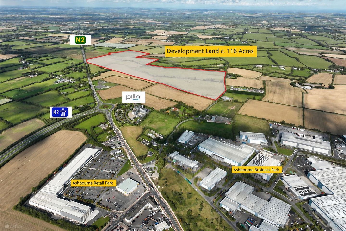

Zoned Land C. 116 Acres, Ballymadun Road, Ashbourne, Dublin 11
Price on Application
- Available From:Immediately
About Zoned Land C. 116 Acres, Ballymadun Road, Ashbourne, Dublin 11
Description
Location: The lands occupy an exceptional strategic location on the northern outskirts of the thriving town of Ashbourne, adjoining the M2 Interchange and the Pillo Hotel, within the administrative boundary of Fingal County Council. Positioned along the N2 / M2 corridor, approximately 23km from Dublin City Centre and 19km from Dublin Airport, the property benefits from excellent connectivity to Dublin and the wider national motorway network. The adjoining M2 / Ashbourne Bypass provides convenient access to the M50 Motorway, Dublin Airport, Dublin Port Tunnel and the principal commercial and logistics centres throughout the Greater Dublin Area. Ashbourne has experienced significant residential, commercial and employment growth over recent years, establishing itself as one of the principal commuter and commercial centres serving North Dublin and County Meath. The town provides an extensive range of amenities, services and facilities, together with access to a substantial and expanding local labour pool. The surrounding area is characterised by a mix of established industrial, commercial and logistics developments, reflecting the importance of the N2 / M2 corridor as a strategic location for business and employment activity. Nearby developments include Ashbourne Business Park, together with a range of other commercial and industrial occupiers. The lands occupy a prominent position adjoining the existing national road infrastructure and currently benefit from two agricultural access points, one directly from the N2 and a second from Ballymadun Road, to the rear of the Pillo Hotel and opposite Ashbourne Business Park. These access points offer potential for future access arrangements to serve the overall landholding, subject to the necessary planning permissions and roads authority approval. The combination of excellent motorway connectivity, proximity to Dublin Airport and the M50, established surrounding commercial activity and the continued expansion of Ashbourne makes this substantial land bank an attractive opportunity for developers, investors and owner-occupiers seeking a strategically located site capable of accommodating significant future commercial and employment-generating development. Description: The property comprises a substantial landholding extending to approximately 116 Acres / 46.9 Hectares, strategically situated adjoining the M2 Interchange on the northern outskirts of Ashbourne. The lands represent a rare opportunity to acquire a sizeable parcel of employment-zoned land in one of the Greater Dublin Area's most accessible and established commercial corridors. The scale of the landholding offers considerable flexibility for a range of potential development layouts, with the capacity to accommodate a single large-scale industrial or logistics occupier, a major distribution facility or a number of individual commercial, industrial and warehousing units, subject to the necessary planning permissions. The property's proximity to the M2 Motorway, M50, Dublin Airport and Dublin Port makes it particularly attractive for logistics, distribution, manufacturing and other employment-generating uses requiring strong transport connections and access to the national road network. With substantial acreage, established surrounding infrastructure and a favourable employment zoning designation, the lands present an excellent opportunity to deliver a significant commercial development in a highly accessible location. Zoning: Town Planning / Zoning The lands are situated within the administrative boundary of Fingal County Council and are zoned “GE” – General Employment, with the following zoning objective: “Provide opportunities for general enterprise and employment.” Zoning Vision “Facilitate opportunities for compatible industry and general employment uses, logistics and warehousing activity in a good quality physical environment. General Employment areas should be highly accessible, well designed, permeable and legible.” The GE zoning designation is particularly suited to the strategic nature and scale of this landholding, facilitating a broad range of commercial, industrial, logistics, warehousing and employment-generating activities. The lands' location adjoining the M2 Interchange, together with their excellent connectivity to the M50 Motorway, Dublin Airport and the wider national road network, further enhances their suitability for significant employment-led development. The substantial acreage offers potential to accommodate a variety of development formats, ranging from large individual industrial and logistics facilities to a comprehensively planned commercial and employment campus, subject to the necessary planning permissions. Uses Permitted in Principle Under the GE zoning objective, the following uses are listed as permitted in principle: Builders Provider / Yard, Civic Waste Facility, Enterprise Centre, Food, Drink & Flower Preparation / Processing, Fuel Depot / Fuel Storage, High Technology Manufacturing, Industry – General, Industry – Light, Logistics, Warehousing, Office Ancillary to Permitted Use, Petrol Station, Research & Development, Restaurant / Café, Retail – Local (under 150 sq.m), Road Transport Depot, Telecommunications Structures, Training Centre, Utility Installations, Vehicle Sales Outlet – Small Vehicles, Vehicle Sales Outlet – Large Vehicles, Vehicle Servicing / Maintenance, Garage, Waste Disposal & Recovery Facility (Excluding High Impact) and Wholesale. Key Features: • Substantial Landholding: Extending to approximately 116 Acres / 46.9 Hectares, representing a rare opportunity to acquire a significant employment-zoned land bank within the Greater Dublin Area. • Prime Strategic Location: Prominently situated along the N2 / M2 corridor, adjoining the M2 Interchange on the northern outskirts of Ashbourne. • Excellent Motorway Connectivity: Convenient access to the M2 and M50 Motorways, providing onward connections to Dublin City Centre, Dublin Airport, Dublin Port and the wider national motorway network. • General Employment Zoning: Zoned “GE – General Employment” under the Fingal Development Plan, facilitating a broad range of industrial, logistics, warehousing, manufacturing and employment-generating uses. • Significant Development Potential: The substantial acreage offers flexibility to accommodate a single large-scale occupier or a comprehensively planned development comprising multiple industrial, logistics and commercial facilities, subject to planning permission. • Potential for Dual Access: Existing agricultural access points from the N2 and Ballymadun Road offer potential for future access arrangements, subject to the necessary statutory consents and roads authority approval. • Established Commercial Setting: Situated adjoining the expanding town of Ashbourne and close to established commercial and industrial developments, including Ashbourne Business Park. • Access to Skilled Labour: The property's proximity to Ashbourne, North Dublin and the wider Greater Dublin Area provides access to a substantial labour pool. Strategic Investment Opportunity: A rare opportunity to acquire a sizeable, strategically positioned employment-zoned landholding with potential for significant future commercial development
The local area of Zoned Land C. 116 Acres, Ballymadun Road, Ashbourne, Dublin 11
Local schools and transport

Learn more about what this area has to offer.
School Name | Distance | Pupils | |||
|---|---|---|---|---|---|
| School Name | St Mary's National School | Distance | 1.6km | Pupils | 481 |
| School Name | Ashbourne Educate Together National School | Distance | 2.0km | Pupils | 410 |
| School Name | Ashbourne Community National School | Distance | 2.0km | Pupils | 303 |
School Name | Distance | Pupils | |||
|---|---|---|---|---|---|
| School Name | Gaelscoil Na Mí | Distance | 2.1km | Pupils | 283 |
| School Name | St Andrew's Curragha | Distance | 2.5km | Pupils | 112 |
| School Name | St Declan's National School Ashbourne | Distance | 2.7km | Pupils | 647 |
| School Name | Gaelscoil Na Cille | Distance | 3.1km | Pupils | 227 |
| School Name | Garristown National School | Distance | 4.0km | Pupils | 187 |
| School Name | St Paul's National School Ratoath | Distance | 4.2km | Pupils | 576 |
| School Name | Ratoath Senior National School | Distance | 4.8km | Pupils | 360 |
School Name | Distance | Pupils | |||
|---|---|---|---|---|---|
| School Name | De Lacy College | Distance | 2.1km | Pupils | 913 |
| School Name | Ashbourne Community School | Distance | 3.1km | Pupils | 1111 |
| School Name | Ratoath College | Distance | 4.7km | Pupils | 1112 |
School Name | Distance | Pupils | |||
|---|---|---|---|---|---|
| School Name | Coláiste Rioga | Distance | 8.9km | Pupils | 193 |
| School Name | Community College Dunshaughlin | Distance | 9.5km | Pupils | 1135 |
| School Name | Le Chéile Secondary School | Distance | 12.8km | Pupils | 959 |
| School Name | St. Peter's College | Distance | 13.0km | Pupils | 1227 |
| School Name | Loreto College Swords | Distance | 13.6km | Pupils | 632 |
| School Name | Swords Community College | Distance | 14.1km | Pupils | 930 |
| School Name | St. Finian's Community College | Distance | 14.1km | Pupils | 661 |
Type | Distance | Stop | Route | Destination | Provider | ||||||
|---|---|---|---|---|---|---|---|---|---|---|---|
| Type | Bus | Distance | 620m | Stop | Ashbourne Bp | Route | 195 | Destination | Balbriggan | Provider | Tfi Local Link Louth Meath Fingal |
| Type | Bus | Distance | 680m | Stop | Rath | Route | 105 | Destination | Drogheda | Provider | Bus Éireann |
| Type | Bus | Distance | 680m | Stop | Rath | Route | 103x | Destination | Duleek | Provider | Bus Éireann |
Type | Distance | Stop | Route | Destination | Provider | ||||||
|---|---|---|---|---|---|---|---|---|---|---|---|
| Type | Bus | Distance | 680m | Stop | Rath | Route | 194 | Destination | Stephen's Green Nth | Provider | Ashbourne Connect |
| Type | Bus | Distance | 680m | Stop | Rath | Route | 193 | Destination | Stephen's Green Nth | Provider | Ashbourne Connect |
| Type | Bus | Distance | 690m | Stop | Rath | Route | 197 | Destination | Swords | Provider | Go-ahead Ireland |
| Type | Bus | Distance | 900m | Stop | Ballybin Road | Route | 105 | Destination | Parkway Station | Provider | Bus Éireann |
| Type | Bus | Distance | 900m | Stop | Ballybin Road | Route | 109a | Destination | Dublin Airport | Provider | Bus Éireann |
| Type | Bus | Distance | 900m | Stop | Ballybin Road | Route | 103x | Destination | St. Stephen's Green | Provider | Bus Éireann |
| Type | Bus | Distance | 920m | Stop | Ashbourne Rp | Route | 194 | Destination | Skryne Road | Provider | Ashbourne Connect |
BER Details
Ad performance
- Date listed17/11/2026
- Views27
Daft ID: 56723815