
Lands At Cheekpoint, Co. Waterford
€590,000
- Selling Type:By Private Treaty
About Lands At Cheekpoint
Description
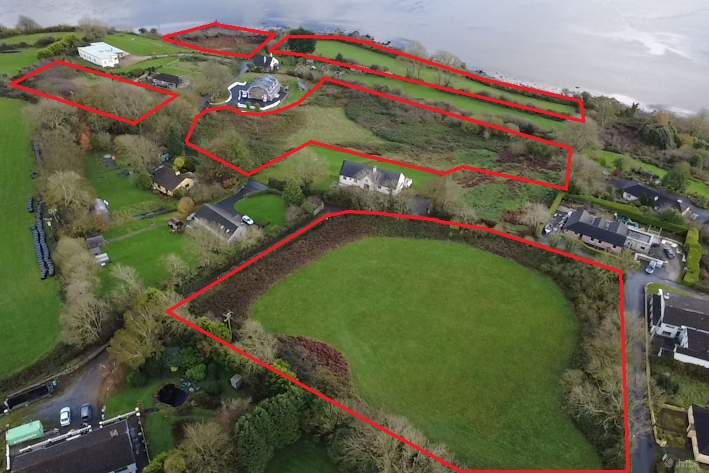
This substantial parcel of land suitable for residential development extends to approx. 5.05 Ac the entire lands for sale extending to approx. 7.37 Ac. These lands could be used for open space and to service the site. With a feasibility study available upon request showing development potential for 49 houses a mixture of 3 and 4 beds with detached and semi-detached houses. The lands are zoned under the Waterford County Council Local Area Development Plan 2022 - 2028, Cheekpoint is identified as "RV - Rural Villages" - Protect and promote the character of the Rural Village and promote a vibrant community appropriate to available physical and community infrastructure. Under this zoning, residenital development is permitted in principal. As outlined in the Waterford development plan under point H26 "We will support the proportionate growth of appropriately designed development in rural towns and villages that will contribute to their regeneration and renewal." In the interest of delivering Housing for All and other programs seeking to provide social and affordable housing, the development of social and affordable housing by an Approved Housing Body, State Agency/Body or the Housing Authority on lands zoned for Strategic Residential Reserve (SRR) may be considered acceptable subject to compliance with the policy objectives and development management standards of the Development Plan. Similarly, social and affordable housing schemes on land zoned Rural Village (RV) may also be facilitated. Within the previous local area development plan 2011 - 2017 all three plots of land identified as follows; R1 – Protect amenity of existing residential development and provide new residential development – medium density R2 – Protect amenity of existing residential development and provide new residential development – low density (clustered housing, serviced sites, large plot size). DO6 This site can accommodate medium density residential development. Development of the site shall provide for roadside improvements. DO7 This site can accommodate low density residential development. Development of the site shall provide for roadside improvements, public footpath/cycle-path and public lighting. The topography of the site should be considered in the layout of the development and the amount of cut and fill required shall be minimised. Development shall not detract from the visual setting of the River Suir. With the plots of land having been identified as reisential zoned lands in the previous development plan as well, this gives precident for future development of the site.
The local area of Lands At Cheekpoint
Sold properties in this area
Stay informed with market trends
Local schools and transport

Learn more about what this area has to offer.
School Name | Distance | Pupils | |||
|---|---|---|---|---|---|
| School Name | Faithlegg National School | Distance | 1.1km | Pupils | 205 |
| School Name | Ballyhack National School | Distance | 2.9km | Pupils | 58 |
| School Name | Passage East National School | Distance | 4.3km | Pupils | 104 |
School Name | Distance | Pupils | |||
|---|---|---|---|---|---|
| School Name | Ringville Mixed National School | Distance | 4.4km | Pupils | 46 |
| School Name | Scoil Mhuire Horeswood | Distance | 5.2km | Pupils | 239 |
| School Name | Slieverue National School | Distance | 5.3km | Pupils | 212 |
| School Name | Jonah Special School | Distance | 5.4km | Pupils | 12 |
| School Name | Ramsgrange National School | Distance | 5.5km | Pupils | 52 |
| School Name | Duncannon National School | Distance | 6.4km | Pupils | 73 |
| School Name | Gaelscoil Phort Lairge | Distance | 6.5km | Pupils | 202 |
School Name | Distance | Pupils | |||
|---|---|---|---|---|---|
| School Name | Ramsgrange Community School | Distance | 5.8km | Pupils | 628 |
| School Name | Abbey Community College | Distance | 7.3km | Pupils | 998 |
| School Name | Waterpark College | Distance | 7.6km | Pupils | 589 |
School Name | Distance | Pupils | |||
|---|---|---|---|---|---|
| School Name | Newtown School | Distance | 7.6km | Pupils | 406 |
| School Name | De La Salle College | Distance | 7.7km | Pupils | 1031 |
| School Name | Mount Sion Cbs Secondary School | Distance | 8.6km | Pupils | 469 |
| School Name | St Angela's Secondary School | Distance | 8.7km | Pupils | 958 |
| School Name | Our Lady Of Mercy Secondary School | Distance | 9.1km | Pupils | 498 |
| School Name | Presentation Secondary School | Distance | 9.3km | Pupils | 413 |
| School Name | St Paul's Community College | Distance | 10.1km | Pupils | 760 |
Type | Distance | Stop | Route | Destination | Provider | ||||||
|---|---|---|---|---|---|---|---|---|---|---|---|
| Type | Bus | Distance | 2.9km | Stop | Ballyhack Upper | Route | 399 | Destination | New Ross | Provider | Tfi Local Link Wexford |
| Type | Bus | Distance | 3.1km | Stop | Ballyhack Lower | Route | 399 | Destination | Hook Head | Provider | Tfi Local Link Wexford |
| Type | Bus | Distance | 3.6km | Stop | Passage East | Route | 358 | Destination | Crooke | Provider | Tfi Local Link Waterford |
Type | Distance | Stop | Route | Destination | Provider | ||||||
|---|---|---|---|---|---|---|---|---|---|---|---|
| Type | Bus | Distance | 4.0km | Stop | Campile South | Route | 399 | Destination | Hook Head | Provider | Tfi Local Link Wexford |
| Type | Bus | Distance | 4.0km | Stop | Horeswood | Route | 399 | Destination | New Ross | Provider | Tfi Local Link Wexford |
| Type | Bus | Distance | 4.1km | Stop | Arthurstown | Route | 399 | Destination | Hook Head | Provider | Tfi Local Link Wexford |
| Type | Bus | Distance | 4.3km | Stop | Campile | Route | 370 | Destination | Rosslare Harbour | Provider | Bus Éireann |
| Type | Bus | Distance | 4.3km | Stop | Campile | Route | 399 | Destination | Hook Head | Provider | Tfi Local Link Wexford |
| Type | Bus | Distance | 4.6km | Stop | Crooke | Route | 358 | Destination | Waterford | Provider | Tfi Local Link Waterford |
| Type | Bus | Distance | 5.3km | Stop | Rathpatrick | Route | 607 | Destination | Ballygunner | Provider | Jj Kavanagh |
Your Mortgage and Insurance Tools
Check off the steps to purchase your new home
Use our Buying Checklist to guide you through the whole home-buying journey.
Budget calculator
Calculate how much you can borrow and what you'll need to save
Ad performance
- Date listed21/11/2025
- Views4,422
- Potential views if upgraded to an Advantage Ad7,208
Properties similar to Lands At Cheekpoint

Daft ID: 16328269